Riverbanks serve as vital ecosystems that support diverse wildlife and help prevent soil erosion by stabilizing the river's edge. Healthy riverbanks contribute to improved water quality and provide natural habitats crucial for fish, birds, and other species. Explore the rest of the article to learn how you can help protect and restore riverbanks effectively.
Table of Comparison
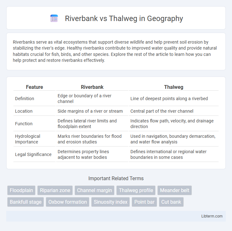
| Feature | Riverbank | Thalweg |
|---|---|---|
| Definition | Edge or boundary of a river channel | Line of deepest points along a riverbed |
| Location | Side margins of a river or stream | Central part of the river channel |
| Function | Defines lateral river limits and floodplain extent | Indicates flow path, velocity, and drainage direction |
| Hydrological Importance | Marks river boundaries for flood and erosion studies | Used in navigation, boundary demarcation, and water flow analysis |
| Legal Significance | Determines property lines adjacent to water bodies | Defines international or regional water boundaries in some cases |
Understanding Riverbank and Thalweg: Key Definitions
Riverbank refers to the land alongside a river, marking the boundary between the water and terrestrial terrain, essential for defining floodplain limits and habitat zones. Thalweg represents the line of deepest points within a river channel, indicating the primary flow path and serving as a critical reference in hydrology and international boundary demarcations. Understanding the distinctions between riverbank and thalweg is vital for accurate river management, navigation, and legal water boundary definitions.
Geographical Significance of Riverbanks
Riverbanks serve as critical geographical boundaries that define the edges of a river channel, influencing floodplain development, sediment deposition, and ecosystem habitats. Their stability affects erosion patterns and water flow, playing a vital role in landform shaping and river navigation. Unlike the thalweg, which marks the deepest line along a riverbed, riverbanks determine the lateral extent of the water body and adjacent terrestrial zones.
The Role of the Thalweg in River Systems
The thalweg represents the line of fastest flow and deepest channel within a river, crucial for defining river morphology and sediment transport dynamics. Its position influences erosion and deposition patterns, directly shaping riverbank stability and channel migration. Understanding the thalweg's role helps in effective river management, navigation, and flood control by predicting flow behavior and identifying potential areas of bank erosion.
Formation Processes: Riverbank vs. Thalweg
Riverbanks form through the accumulation of sediments deposited by slower-moving water along the edges of a river channel, influenced by erosion, vegetation, and soil composition. The thalweg, representing the deepest continuous line along the riverbed, develops from the erosive force of faster-flowing water concentrating in the channel's center, shaping the primary flow path. These contrasting formation processes underscore the dynamic interplay between sediment deposition and erosion in sculpting river morphology.
Ecological Impact: Biodiversity Along Riverbanks and Thalwegs
Riverbanks provide critical habitats for diverse flora and fauna, supporting riparian vegetation that stabilizes soil and offers food and shelter for aquatic and terrestrial species, enhancing overall biodiversity. Thalwegs, as the deepest and fastest-flowing parts of a river channel, influence sediment transport and water quality, creating dynamic environments that sustain specialized aquatic organisms adapted to rapid currents. The interplay between riverbank vegetation and thalweg hydrodynamics maintains ecological balance, promotes habitat heterogeneity, and supports resilient river ecosystems crucial for biodiversity conservation.
Riverbank Stability vs. Thalweg Dynamics
Riverbank stability is influenced by vegetation, soil composition, and erosion processes that protect the edge of the river from collapsing. Thalweg dynamics refer to the deepest part of the river channel where water velocity is highest, shaping sediment transport and channel morphology. Understanding the interaction between stable riverbanks and the shifting thalweg is crucial for predicting river behavior and managing flood risks effectively.
Importance in Hydrology and Water Management
The riverbank defines the lateral boundaries of a water channel, crucial for floodplain delineation, erosion control, and habitat preservation in hydrology and water management. The thalweg, representing the line of deepest flow within a river channel, is essential for determining flow velocity, sediment transport, and navigation paths. Understanding both riverbank and thalweg locations enables accurate flood risk assessment, effective river engineering, and sustainable watershed management.
Legal Boundaries: Riverbank and Thalweg in Land Disputes
The riverbank is the edge of a river and often marks property boundaries, while the thalweg is the deepest channel line used in legal definitions of navigable rivers for boundary determination. In land disputes, courts frequently rely on the thalweg to establish jurisdiction because it represents the main navigable channel and can shift over time, unlike the more stable riverbank. Legal frameworks distinguish these features to clarify property limits, affecting riparian rights and responsibilities.
Human Interaction: Settlements, Agriculture, and Infrastructure
Human settlements tend to develop along riverbanks due to easier access to water resources for agriculture and daily use, making these areas critical for irrigation and crop cultivation. Infrastructure such as bridges, roads, and levees are often constructed near riverbanks to support transportation and protect against flooding. The thalweg, representing the deepest channel line, is less accessible and less developed but is vital for navigation and determining political boundaries in water management practices.
Conservation and Sustainable Management Practices
Riverbank stability is crucial for preventing erosion and maintaining aquatic habitats, which supports biodiversity conservation and water quality. Thalweg mapping guides sustainable river channel management by identifying the deepest flow paths, aiding in flood control and sediment transport regulation. Integrating riverbank restoration with thalweg analysis enhances ecosystem resilience and promotes long-term sustainability in watershed management.
Riverbank Infographic