Cartography shapes your understanding of geography by transforming spatial data into detailed maps that reveal patterns and relationships. Modern techniques combine traditional skills with digital tools like GIS to enhance accuracy and usability. Explore the full article to discover how cartography impacts navigation, urban planning, and environmental management.
Table of Comparison
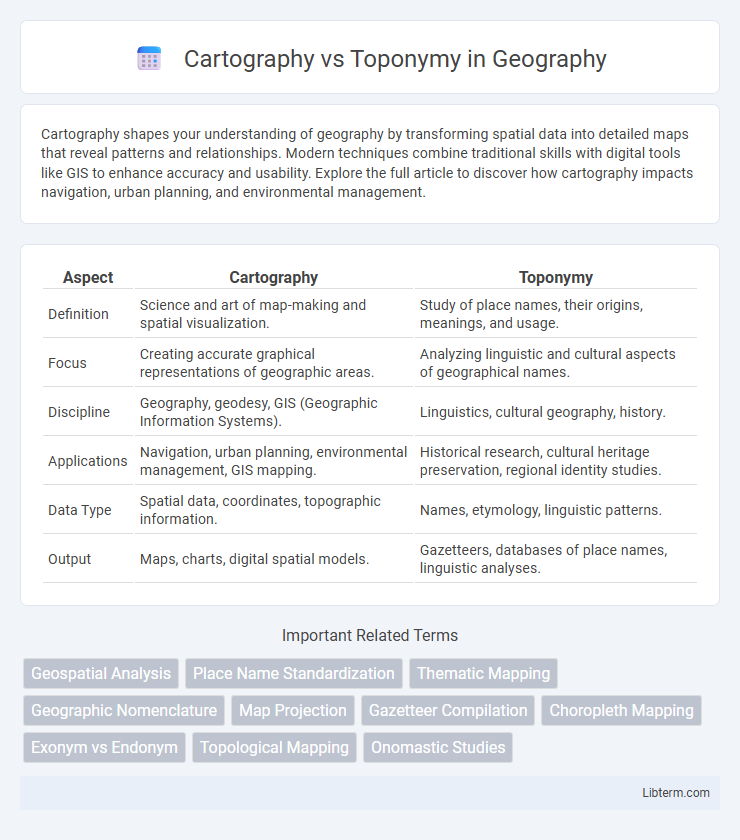
| Aspect | Cartography | Toponymy |
|---|---|---|
| Definition | Science and art of map-making and spatial visualization. | Study of place names, their origins, meanings, and usage. |
| Focus | Creating accurate graphical representations of geographic areas. | Analyzing linguistic and cultural aspects of geographical names. |
| Discipline | Geography, geodesy, GIS (Geographic Information Systems). | Linguistics, cultural geography, history. |
| Applications | Navigation, urban planning, environmental management, GIS mapping. | Historical research, cultural heritage preservation, regional identity studies. |
| Data Type | Spatial data, coordinates, topographic information. | Names, etymology, linguistic patterns. |
| Output | Maps, charts, digital spatial models. | Gazetteers, databases of place names, linguistic analyses. |
Introduction to Cartography and Toponymy
Cartography is the scientific practice of creating maps that visually represent geographical information, emphasizing spatial accuracy and data visualization. Toponymy, as a specialized branch of geography, focuses on the study, origin, and meaning of place names, providing cultural and historical context. Both disciplines intersect in geographic information systems (GIS) and play essential roles in understanding and interpreting spatial data.
Defining Cartography: The Art and Science of Mapping
Cartography combines artistic skill and scientific techniques to create accurate maps that represent geographical spaces and spatial relationships. It involves data collection, geographic information system (GIS) technology, and visualization methods to produce detailed and functional maps. This field contrasts with toponymy, which specifically studies the origin and meaning of place names rather than the broader mapping process.
Understanding Toponymy: The Study of Place Names
Toponymy, a specialized branch of onomastics, systematically studies the origins, meanings, and usage of place names, offering crucial insights into cultural history, geography, and linguistics. Unlike cartography, which focuses on the creation and design of maps for spatial representation, toponymy emphasizes the semantic and historical layers embedded within geographic names. The analysis of toponyms reveals patterns of settlement, migration, and environmental interaction, enriching the interpretation of spatial data beyond mere geographic coordinates.
Historical Evolution of Cartography and Toponymy
Cartography evolved from ancient map-making techniques in Mesopotamia and Egypt, developing through Greek, Roman, and medieval European advancements that enhanced geographic representation accuracy. Toponymy, the study of place names, emerged alongside cartography in early civilizations where names encoded cultural, historical, and linguistic information crucial for navigation and territorial claims. The historical interplay between cartographic map production and toponymic naming conventions reveals how spatial knowledge and cultural identity shaped geographic understanding across centuries.
Key Differences Between Cartography and Toponymy
Cartography focuses on the art and science of map-making, involving the design, production, and study of spatial representations of geographic information. Toponymy is the study of place names, their origins, meanings, and usage within a linguistic and cultural context. Key differences lie in cartography's emphasis on graphical representation and navigation tools, while toponymy centers on the linguistic, historical, and cultural significance of geographic names.
The Role of Cartography in Geographic Visualization
Cartography plays a crucial role in geographic visualization by transforming raw spatial data into detailed, visually comprehensible maps that facilitate the analysis of geographic patterns and relationships. Unlike toponymy, which focuses on the origin and meaning of place names, cartography integrates these names with physical and cultural features to create layered, interactive representations essential for urban planning, navigation, and environmental monitoring. Advanced cartographic techniques use GIS (Geographic Information Systems) to enhance spatial accuracy and enable dynamic visualization, making cartography indispensable for geographic data interpretation.
Toponymy in Cultural and Linguistic Contexts
Toponymy examines place names as cultural artifacts reflecting historical, linguistic, and social dimensions of human communities. It reveals how language evolution, migration, and identity shape geographic nomenclature, preserving indigenous knowledge and heritage. Unlike cartography, which focuses on map-making and spatial representation, toponymy centers on the significance and origin of names within cultural and linguistic frameworks.
Applications of Cartography and Toponymy in Modern Society
Cartography enhances geographic understanding by creating detailed maps that support urban planning, navigation, and environmental monitoring, crucial for disaster management and resource allocation. Toponymy enriches cultural identity and heritage preservation by analyzing place names, aiding linguists, historians, and geographers in decoding historical land use and migration patterns. Together, these fields optimize spatial data interpretation, improving decision-making in government, tourism, and spatial analytics industries.
Interconnections: How Cartography and Toponymy Overlap
Cartography and toponymy intersect through the essential role of place names in map-making, where toponyms provide precise geographic identifiers that enhance spatial representation and navigation. The integration of toponymic data in cartographic systems supports cultural heritage preservation by embedding historical and linguistic context within maps. Geographic Information Systems (GIS) further bridge these fields by enabling dynamic visualization and analysis of toponymic patterns across diverse regions.
Future Trends in Mapping and Place Name Studies
Emerging advancements in geographic information systems (GIS) and artificial intelligence are revolutionizing cartography and toponymy by enabling dynamic, real-time mapping and automated place name analysis. Integration of big data and crowdsourced geospatial inputs enhances accuracy and cultural relevance, fostering more inclusive and context-aware digital maps. Future trends emphasize the convergence of semantic web technologies with spatial data infrastructure to support personalized navigation and enriched spatial storytelling.
Cartography Infographic