Slope measures the steepness or incline of a surface and is calculated as the ratio of vertical change to horizontal distance. It plays a crucial role in fields such as construction, landscaping, and mathematics, affecting drainage and stability. Discover how understanding slope can improve your projects by exploring the rest of this article.
Table of Comparison
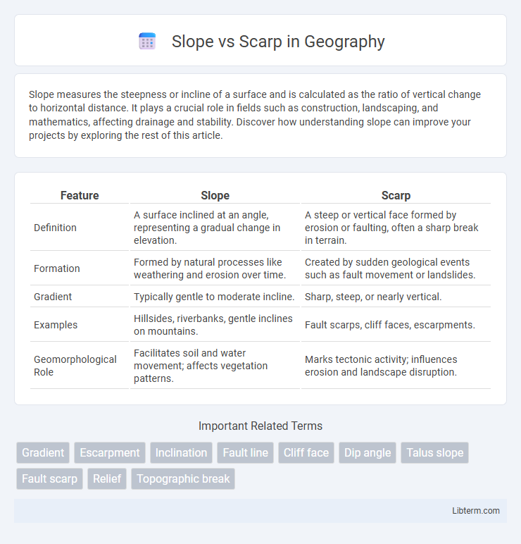
| Feature | Slope | Scarp |
|---|---|---|
| Definition | A surface inclined at an angle, representing a gradual change in elevation. | A steep or vertical face formed by erosion or faulting, often a sharp break in terrain. |
| Formation | Formed by natural processes like weathering and erosion over time. | Created by sudden geological events such as fault movement or landslides. |
| Gradient | Typically gentle to moderate incline. | Sharp, steep, or nearly vertical. |
| Examples | Hillsides, riverbanks, gentle inclines on mountains. | Fault scarps, cliff faces, escarpments. |
| Geomorphological Role | Facilitates soil and water movement; affects vegetation patterns. | Marks tectonic activity; influences erosion and landscape disruption. |
Introduction to Slope and Scarp
A slope is an inclined surface or gradient of land, commonly found in natural landscapes such as hillsides and mountainsides, characterized by the angle of inclination relative to the horizontal plane. A scarp, on the other hand, is a steep or abrupt slope or cliff formed by erosion, faulting, or landslides, often marking a distinct boundary or change in elevation. Understanding the difference between slope and scarp is essential in geomorphology and earth sciences for analyzing landform processes and stability.
Defining Slope: Concepts and Characteristics
Slope refers to the inclined surface or gradient of a landform, measured as the ratio of vertical rise to horizontal distance, typically expressed in degrees or percentage. It is characterized by factors such as steepness, length, and shape, which influence erosion, drainage patterns, and vegetation distribution. Unlike scarps, which are steep, abrupt changes in elevation caused by faulting or erosion, slopes represent more gradual transitions in terrain.
Understanding Scarp: Formation and Features
A scarp forms as a steep slope or cliff resulting from processes like faulting, erosion, or landslides, often marking a sharp elevation change in the landscape. Scarps commonly indicate tectonic activity where one side of a fault moves relative to the other, creating a visible break in the Earth's surface. Their distinct features include a pronounced, abrupt incline that differs from the generally gentler gradient of a slope, highlighting geological or geomorphological events.
Geological Processes Shaping Slopes
Slopes form through gradual processes like weathering, erosion, and deposition, which reshape the landscape over time. Scarps are steep, often abrupt slopes created by tectonic activity, such as faulting or land uplift, that expose fresh geological layers. The interaction of mass wasting, soil creep, and seismic events continuously modifies these features, illustrating dynamic Earth surface evolution.
Scarp Formation: Causes and Types
Scarps form due to tectonic activity, erosion, or faulting, resulting in steep slopes or cliffs that mark abrupt changes in elevation. Common scarp types include fault scarps from earthquakes, erosional scarps formed by weathering and water action, and coastal scarps shaped by wave erosion. The intensity and nature of the geological processes influence the scarp's height, shape, and stability.
Key Differences Between Slope and Scarp
A slope is a general incline or gradient of the land surface, varying in steepness and often formed by gradual erosion or sediment deposition. In contrast, a scarp is a steep, often vertical, cliff or steep slope formed by faulting, landslides, or erosion processes, marking a distinct break in terrain elevation. The key difference lies in their formation and steepness, with slopes representing gentle to moderate inclines and scarps indicating abrupt changes in topography.
Slope Stability and Erosion Factors
Slope stability is influenced by factors including soil composition, moisture content, and vegetation cover, which affect the potential for both gradual slope failure and sudden collapse. Scarps, as steep, often vertical faces formed by active erosion or mass wasting, indicate zones of pronounced instability where soil and rock layers have separated or moved. Erosion factors such as rainfall intensity, runoff, and seismic activity accelerate slope degradation and increase the likelihood of scarp formation and landslides.
Scarp in Landform Classification
Scarp refers to a steep slope or cliff formed by erosion or faulting that distinctly separates two land surfaces of different elevations. In landform classification, scarps are critical indicators of tectonic activity and geomorphological processes, often marking fault lines or the edge of uplifted terrain. Unlike general slopes that represent gradual inclines, scarps exhibit abrupt vertical or near-vertical breaks, influencing drainage patterns and landscape evolution.
Real-World Examples of Slopes and Scarps
The Grand Canyon showcases a stunning example of slopes formed by gradual erosion of sedimentary rock layers, creating gently inclined surfaces that extend over vast distances. The San Andreas Fault in California features prominent scarps, where sudden vertical displacement during earthquakes has produced steep, abrupt cliffs along the fault line. Mount Fuji in Japan displays both features, with its smooth volcanic slopes contrasted by scarps created by landslides and tectonic activity.
Importance of Slope and Scarp in Geomorphology
Slope and scarp are fundamental geomorphological features that influence landscape development, erosion patterns, and sediment transport. The slope, defined by its gradient and orientation, controls water runoff and soil stability, directly affecting vegetation distribution and landform processes. Scarps, often resulting from faulting or erosion, provide critical insights into tectonic activity and landscape evolution, making them essential for hazard assessment and geological mapping.
Slope Infographic