A basin is a natural or artificially created depression on the Earth's surface, often serving as a catchment area for water, sediments, and organic material. These geographical features play a crucial role in ecosystems, water management, and human settlements by directing water flow and supporting biodiversity. Explore the rest of the article to understand how basins impact your environment and everyday life.
Table of Comparison
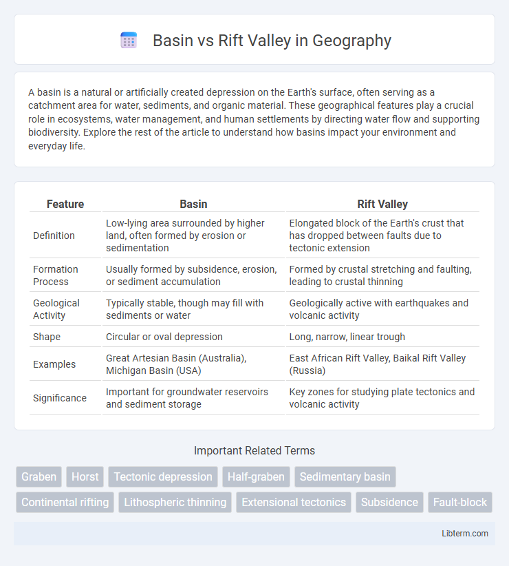
| Feature | Basin | Rift Valley |
|---|---|---|
| Definition | Low-lying area surrounded by higher land, often formed by erosion or sedimentation | Elongated block of the Earth's crust that has dropped between faults due to tectonic extension |
| Formation Process | Usually formed by subsidence, erosion, or sediment accumulation | Formed by crustal stretching and faulting, leading to crustal thinning |
| Geological Activity | Typically stable, though may fill with sediments or water | Geologically active with earthquakes and volcanic activity |
| Shape | Circular or oval depression | Long, narrow, linear trough |
| Examples | Great Artesian Basin (Australia), Michigan Basin (USA) | East African Rift Valley, Baikal Rift Valley (Russia) |
| Significance | Important for groundwater reservoirs and sediment storage | Key zones for studying plate tectonics and volcanic activity |
Introduction to Basins and Rift Valleys
Basins are low-lying regions often formed by sediment accumulation or crustal subsidence, serving as crucial sites for water collection and sediment deposition. Rift valleys are elongated depressions created by tectonic plate divergence, characterized by steep walls and significant volcanic activity. Both geological features influence landscape formation, hydrology, and biodiversity in distinct ways, reflecting the dynamic processes shaping the Earth's surface.
Geological Definitions: Basin vs Rift Valley
A basin is a low-lying geological depression typically formed by subsidence, sediment accumulation, or erosion, often creating a broad, flat area that can hold water or sediment layers. A rift valley is a linear-shaped lowland between highlands or mountain ranges formed by the tectonic process of extensional faulting where the Earth's crust is pulled apart. While basins can result from various geological processes, rift valleys specifically originate from divergent tectonic plate boundaries causing crustal thinning and subsidence.
Formation Processes: How Basins and Rift Valleys Develop
Basins form through subsidence caused by tectonic activity, sediment loading, or crustal cooling, creating low-lying areas that accumulate sediments over time. Rift valleys develop specifically from the divergent movement of tectonic plates, where the Earth's crust stretches and thins, causing it to crack and drop between parallel faults. Both geological features result from crustal deformation but differ in their tectonic settings and mechanisms of formation.
Tectonic Settings: Where Basins and Rift Valleys Occur
Basins commonly form in diverse tectonic settings, including passive continental margins, foreland areas adjacent to mountain belts, and intraplate zones where sediment accumulates due to subsidence. Rift valleys specifically develop in divergent tectonic boundaries where continental crust is stretched and thinned, leading to faulting and the creation of elongated troughs. Key examples of rift valleys include the East African Rift, formed by the splitting of the African Plate, highlighting active tectonic extension processes unlike the typically more stable settings of many sedimentary basins.
Key Geological Features of Basins
Basins are low-lying geological depressions typically formed by subsidence of the Earth's crust, trapping sediments and water, and often characterized by thick sedimentary layers that record extensive geological history. Rift valleys develop as a result of tectonic plates pulling apart, creating elongated, steep-sided troughs with active faulting and volcanic activity. Unlike rift valleys, basins usually exhibit more stable sediment accumulation and less intense tectonic deformation, making them crucial for understanding sedimentary processes and resource accumulation such as oil and groundwater.
Key Geological Features of Rift Valleys
Rift valleys are elongated depressions formed by the diverging movement of tectonic plates, characterized by steep, faulted sidewalls and a flat valley floor often occupied by lakes or rivers. These valleys are bounded by normal faults creating a series of horsts and grabens, and are typically associated with volcanic activity as magma rises through the thinning crust. The East African Rift Valley exemplifies these key features, containing active volcanoes, geothermal activity, and a complex network of faults shaping the landscape.
Global Examples: Major Basins vs Rift Valleys
The Amazon Basin in South America is one of the world's largest and most fertile river basins, characterized by extensive sediment deposits and diverse ecosystems. The East African Rift Valley, stretching from Ethiopia to Mozambique, is a prominent active continental rift zone featuring deep lakes, volcanic activity, and significant tectonic divergence. The Siberian Basin in Russia, rich in oil and gas reserves, contrasts with the Baikal Rift Valley, the world's deepest freshwater lake formed by tectonic rifting.
Ecological and Environmental Impacts
Basins often serve as vital water catchment areas that support diverse ecosystems and foster wetlands, enhancing biodiversity and providing habitats for numerous species. Rift valleys, formed by tectonic plate movements, create unique microclimates and habitats that can lead to high levels of endemism but also face risks of soil erosion and seismic activity. Both landforms influence local water cycles, soil fertility, and vegetation patterns, substantially impacting regional ecological balance and environmental sustainability.
Economic and Human Significance
Basins often support agriculture and human settlements due to their fertile soils and water availability, making them crucial for food production and population centers. Rift valleys are economically significant for their natural resources such as minerals and geothermal energy, attracting mining and energy industries. Both features influence trade routes and urban development, shaping regional economies and human livelihoods.
Summary: Comparing Basins and Rift Valleys
Basins and rift valleys both represent depressions in the Earth's surface formed by tectonic activity, but basins typically result from subsidence or sediment accumulation within structural lows, whereas rift valleys form through the extensional tectonics and crustal pulling apart. Rift valleys often exhibit active faulting and volcanic activity due to divergent plate boundaries, while basins may be more stable and accumulate thick sedimentary deposits over time. Understanding these differences aids in geological mapping, natural resource exploration, and assessing seismic hazards.
Basin Infographic