Climate zones categorize regions based on patterns of temperature, humidity, and precipitation, influencing ecosystems, agriculture, and human activities. Understanding the specific characteristics of your local climate zone can help optimize energy use, crop selection, and disaster preparedness. Explore the rest of the article to discover how climate zones impact your environment and daily life.
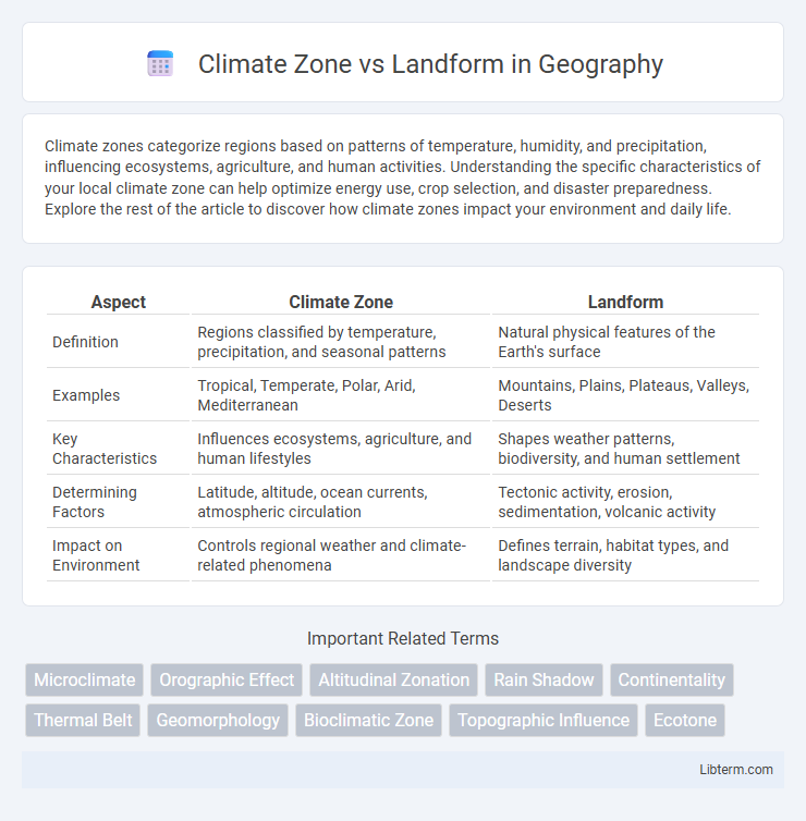
Table of Comparison
| Aspect | Climate Zone | Landform |
|---|---|---|
| Definition | Regions classified by temperature, precipitation, and seasonal patterns | Natural physical features of the Earth's surface |
| Examples | Tropical, Temperate, Polar, Arid, Mediterranean | Mountains, Plains, Plateaus, Valleys, Deserts |
| Key Characteristics | Influences ecosystems, agriculture, and human lifestyles | Shapes weather patterns, biodiversity, and human settlement |
| Determining Factors | Latitude, altitude, ocean currents, atmospheric circulation | Tectonic activity, erosion, sedimentation, volcanic activity |
| Impact on Environment | Controls regional weather and climate-related phenomena | Defines terrain, habitat types, and landscape diversity |
Understanding Climate Zones: A Brief Overview
Climate zones are categorized based on factors such as temperature, precipitation, and seasonal patterns, directly influencing the ecosystems within various landforms like mountains, plains, and plateaus. Each landform interacts uniquely with climate zones, shaping biodiversity, weather patterns, and human activities in the region. Understanding climate zones involves analyzing these interactions to predict environmental conditions, support agriculture, and manage natural resources effectively.
Defining Landforms: Types and Characteristics
Landforms are natural physical features on the Earth's surface, categorized into various types such as mountains, plateaus, valleys, plains, and hills, each with distinct characteristics shaped by geological processes like erosion, volcanic activity, and tectonic movements. Mountains feature elevated terrains with steep slopes and significant altitude, while plains offer extensive flat areas often formed by sediment deposition. Understanding these landforms is crucial for studying climate zones since the elevation, shape, and orientation of landforms influence local climate patterns, precipitation distribution, and temperature variations.
How Climate Zones Influence Landforms
Climate zones significantly influence landforms by shaping erosion patterns, soil formation, and vegetation cover, which in turn affect the landscape's physical structure. Arid climate zones promote the formation of desert landforms like dunes and playas, while humid tropical climates contribute to dense vegetation and weathering processes that create rounded hills and deep valleys. Temperature and precipitation variations within different climate zones drive distinct geological and geomorphological processes, ultimately molding diverse landforms globally.
The Impact of Landforms on Local Climate
Landforms such as mountains, valleys, and plateaus significantly influence local climate by affecting temperature, precipitation, and wind patterns. Mountains create rain shadows, causing one side to receive heavy rainfall while the other remains arid, altering local ecosystems. Coastal landforms modify temperature ranges by moderating extremes through oceanic influences, shaping microclimates.
Examples of Climate Zone and Landform Interactions
Tropical rainforest climate zones, characterized by high temperature and heavy rainfall, often coincide with lowland plains and river basins, fostering dense vegetation and rich biodiversity. In contrast, arid desert climate zones typically align with landforms such as plateaus and mountain rain shadows, resulting in sparse vegetation and limited water resources. Coastal landforms, like peninsulas and bays, interact with maritime climate zones to create moderate temperatures and high humidity, supporting unique ecosystems.
Climate Zones across Different Landforms
Climate zones vary significantly across different landforms due to variations in elevation, slope, and orientation, which influence temperature and precipitation patterns. Mountainous landforms typically experience cooler temperatures and higher rainfall compared to adjacent lowland areas, creating distinct microclimates within the same climate zone. Coastal landforms often have milder, more humid climates, while desert landforms exhibit extreme temperature fluctuations and arid conditions shaped by their topography.
Landform Evolution under Varying Climates
Landform evolution is significantly influenced by varying climate zones, where temperature, precipitation, and weathering processes dictate erosion rates and sediment transport. In arid climates, physical weathering dominates, leading to the formation of features such as desert pavements and alluvial fans, while humid climates promote chemical weathering and soil development, reshaping landscapes into rounded hills and valleys. Fluctuating climates over geological time accelerate or decelerate tectonic uplift and erosion cycles, resulting in diverse landform morphologies adapted to specific climatic conditions.
Human Adaptation to Climate Zones and Landforms
Human adaptation to climate zones and landforms involves modifying behaviors, clothing, housing, and agriculture to suit environmental conditions. In arid desert zones, communities develop water conservation techniques and build homes with thermal insulation to combat extreme heat, while in mountainous regions, terraced farming and layered clothing protect against cold and rugged terrain. Coastal populations often rely on fishing, elevated structures, and flood-resistant infrastructure to manage risks from humidity and sea-level changes.
Climate Change Effects on Landforms and Zones
Climate change intensifies temperature fluctuations and altered precipitation patterns, directly impacting climate zones and accelerating erosion, sediment displacement, and the degradation of landforms such as glaciers, coastal cliffs, and river valleys. Rising temperatures contribute to permafrost thawing and increased landslides, reshaping mountainous and polar landforms while shifting vegetation and soil characteristics across climate zones. These dynamic interactions between climate change and geomorphology result in shifting ecosystem boundaries, threatening biodiversity and human settlements dependent on stable landforms and climatic conditions.
Comparing Major Climate Zones by Landform Features
Major climate zones such as tropical, arid, temperate, and polar demonstrate distinct interactions with landform features like mountains, plateaus, and valleys. Mountain ranges influence local climate zones by causing orographic precipitation and creating rain shadows, thereby shaping arid zones adjacent to humid regions. Coastal lowlands often experience moderated temperatures in temperate zones, while high-elevation plateaus in polar zones exhibit extreme cold and minimal vegetation due to altitude-related climatic factors.
Climate Zone Infographic