A peneplain is a vast, nearly level land surface formed by long-term erosion processes that reduce terrain to a low-relief plain. It represents the final stage of landscape evolution where hills and valleys are worn down almost entirely. Explore the rest of the article to understand how peneplains influence geological and environmental studies.
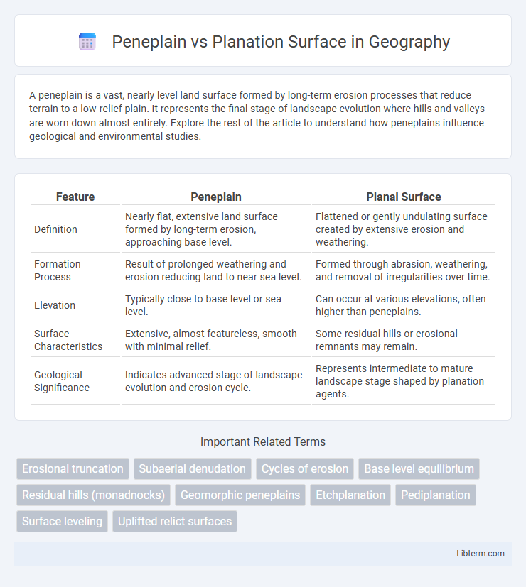
Table of Comparison
| Feature | Peneplain | Planal Surface |
|---|---|---|
| Definition | Nearly flat, extensive land surface formed by long-term erosion, approaching base level. | Flattened or gently undulating surface created by extensive erosion and weathering. |
| Formation Process | Result of prolonged weathering and erosion reducing land to near sea level. | Formed through abrasion, weathering, and removal of irregularities over time. |
| Elevation | Typically close to base level or sea level. | Can occur at various elevations, often higher than peneplains. |
| Surface Characteristics | Extensive, almost featureless, smooth with minimal relief. | Some residual hills or erosional remnants may remain. |
| Geological Significance | Indicates advanced stage of landscape evolution and erosion cycle. | Represents intermediate to mature landscape stage shaped by planation agents. |
Introduction to Peneplain and Planation Surface
A peneplain is an extensive, nearly level land surface formed by long-term erosion, representing the final stage of fluvial landscape evolution. A planation surface refers to a broad, flat or gently undulating area created by various erosional processes, including weathering and denudation, often preceding or distinct from a peneplain. Understanding the differences between peneplains and planation surfaces is essential in geomorphology for interpreting landscape development and tectonic stability.
Defining Peneplain: Concept and Origins
A peneplain is a nearly level land surface produced by prolonged erosion, representing the final stage of fluvial erosion before uplift or other geological processes modify the landscape. Originating from William Morris Davis's cycle of erosion theory, peneplains illustrate the concept of landscape maturity, where rivers have eroded a region almost to base level, leaving minimal topographic relief. Unlike general planation surfaces, which include various flattened landforms formed by diverse processes, peneplains specifically indicate an advanced erosional stage tied to water-driven denudation over geological time.
Understanding Planation Surface: Characteristics and Formation
Planation surfaces are extensive, nearly flat landforms created by prolonged erosion, representing a landscape reduced close to base level. Unlike peneplains, which specifically indicate a late-stage cycle of erosion with slight relief under uplift, planation surfaces encompass varied forms of erosion including abrasion, weathering, and mass wasting across different geological settings. Their formation involves long-term denudation processes that balance uplift and erosion, resulting in broad, stable surfaces that often serve as markers of tectonic stability and landscape evolution.
Geological Processes Behind Peneplain Formation
Peneplains form through prolonged weathering and erosion, gradually reducing landscapes to near-flat surfaces close to sea level, primarily driven by fluvial processes and mass wasting. Planation surfaces encompass a broader category of flattened landforms shaped by various mechanisms including glacial abrasion, wind erosion, and chemical weathering, in addition to river erosion. The key geological distinction lies in peneplains representing end-stage erosion surfaces formed over geological time scales, reflecting tectonic stability and extensive denudation.
Mechanisms Leading to Planation Surfaces
Planation surfaces form through processes such as weathering, mass wasting, and lateral erosion that collectively level landscapes over extended geological periods. Unlike peneplains, which develop primarily through fluvial erosion and represent near base-level conditions, planation surfaces result from a combination of denudation mechanisms including chemical and physical breakdown of rocks. These mechanisms contribute to the gradual reduction of relief, producing broad, nearly flat landforms characteristic of planation surfaces.
Key Differences: Peneplain vs Planation Surface
Peneplains are nearly level land surfaces formed by long-term erosion that approach base level, characterized by residual hills and low relief. Planation surfaces represent broader, more generalized flat or gently undulating terrains shaped by various erosional and depositional processes, including weathering and mass wasting, not necessarily close to base level. The key difference lies in peneplains being a specific type of low-relief erosion surface indicative of prolonged denudation nearing base level, while planation surfaces encompass a wider range of flat or gently sloping landforms formed by diverse geomorphic agents.
Global Examples of Peneplains
Peneplains represent nearly level land surfaces formed by long-term erosion, with the Scandinavian peneplain in Sweden serving as a classic example characterized by its subdued topography and extensive weathering. Planation surfaces include a broader category of flat or gently undulating terrains created by various erosional processes, such as the African etchplain and Australia's Western Plateau. The Canadian Shield also exhibits peneplain features, illustrating their widespread occurrence in ancient cratonic regions where prolonged tectonic stability favors peneplanation.
Notable Instances of Planation Surfaces Worldwide
Planation surfaces are extensive, nearly level landforms created by prolonged erosion, with notable instances including the Scottish Midland Valley and the peneplains of southern Scandinavia. Peneplains, a subtype of planation surfaces, represent nearly flattened landscapes worn down to near base level, exemplified by the Canadian Shield's vast erosion surfaces. These surfaces provide key insights into tectonic stability, climatic history, and landscape evolution on continents such as Australia, Brazil, and Africa.
Significance in Geomorphology and Landscape Evolution
Peneplains represent nearly level land surfaces formed by prolonged erosion and denote a late stage in landscape evolution, indicating tectonic stability. Planation surfaces encompass a broader group of nearly flat or gently undulating surfaces created by various erosional and depositional processes, reflecting different geomorphic histories. Understanding the distinctions between peneplains and planation surfaces is critical for interpreting landscape evolution, tectonic activity, and past climatic conditions in geomorphology.
Conclusion: Comparative Insights and Research Directions
Peneplains represent nearly level land surfaces formed by prolonged erosion close to base level, whereas planation surfaces encompass a broader category of flattened landscapes shaped by various erosional and depositional processes. Comparative studies reveal that peneplains typically record extended tectonic stability, while planation surfaces may reflect episodic uplift and complex geomorphic histories. Future research should integrate high-resolution geochronology and geomorphometric analysis to refine the identification criteria and better understand the interplay between tectonics, climate, and surface processes in shaping these landscapes.
Peneplain Infographic