A watershed is a land area that channels rainfall and snowmelt to creeks, rivers, lakes, and eventually outflow points such as reservoirs, bays, and the ocean. Understanding how watersheds function is crucial for managing water resources, preventing floods, and maintaining ecosystems. Dive into the rest of the article to explore how your local watershed impacts the environment and what you can do to protect it.
Table of Comparison
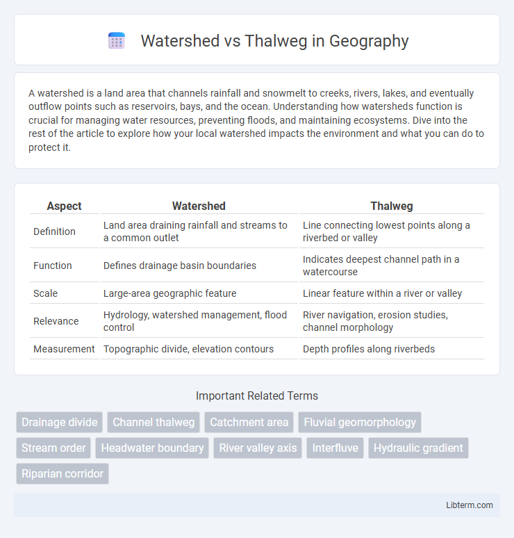
| Aspect | Watershed | Thalweg |
|---|---|---|
| Definition | Land area draining rainfall and streams to a common outlet | Line connecting lowest points along a riverbed or valley |
| Function | Defines drainage basin boundaries | Indicates deepest channel path in a watercourse |
| Scale | Large-area geographic feature | Linear feature within a river or valley |
| Relevance | Hydrology, watershed management, flood control | River navigation, erosion studies, channel morphology |
| Measurement | Topographic divide, elevation contours | Depth profiles along riverbeds |
Introduction to Watershed and Thalweg
A watershed is a land area that channels rainfall and snowmelt into streams and rivers, serving as a crucial hydrological unit for managing water resources and ecosystems. The thalweg represents the line of lowest elevation within a stream or river channel, indicating the path of maximum flow velocity and often used as a natural boundary in water body delineation. Understanding the relationship between watersheds and thalwegs is essential for environmental planning, flood control, and river navigation.
Defining Watershed: Key Features
A watershed is a land area that channels rainfall and snowmelt to creeks, streams, and rivers, ultimately draining into a larger water body, such as an ocean or lake. It is characterized by defined boundaries called drainage divides, which separate adjacent drainage basins. The key features of a watershed include catchment area, flow paths, and outlet points, distinguishing it from a thalweg, which refers specifically to the line of lowest elevation within a valley or river channel.
Understanding the Thalweg: A Basic Overview
The thalweg represents the line of lowest elevation within a riverbed or valley, tracing the deepest points along the channel and often used to define international boundaries or navigation routes. In contrast, a watershed refers to the entire drainage area that channels precipitation and runoff into a specific river or water body, encompassing all tributaries and land surfaces contributing flow. Understanding the thalweg is crucial for hydrologists and geographers as it provides insight into river dynamics, sediment transport, and flood management within a defined watershed.
Watershed Boundaries and Delineation
Watershed boundaries are defined by topographic divides that direct surface water flow toward specific drainage basins, playing a crucial role in hydrological studies and water resource management. Delineation of watershed boundaries typically involves analyzing contour lines, elevation data, and digital elevation models (DEMs) to accurately map the area contributing runoff to a single outlet point. Unlike the thalweg, which traces the deepest channel of a river or stream, watershed boundary delineation focuses on identifying ridgelines that separate distinct drainage areas.
Thalweg Identification in River Systems
Thalweg identification in river systems involves mapping the deepest continuous line along a river channel, which serves as a critical reference for hydraulic analysis and territorial boundary delineation. Advanced techniques such as high-resolution bathymetric surveys and GIS-based terrain modeling enhance the precision of thalweg detection by capturing depth variations and channel morphology. This detailed identification supports flood risk management, navigation safety, and environmental monitoring, distinguishing the thalweg's role from watershed boundaries that mark drainage divides.
Hydrological Functions of Watersheds vs Thalweg
Watersheds function as crucial hydrological units that collect, store, and convey precipitation through surface runoff and groundwater flow, regulating water distribution and quality across drainage basins. Thalwegs represent the deepest continuous line along a river channel, guiding the main flow direction and influencing sediment transport and channel morphology. Together, watersheds determine water availability and nutrient cycling at landscape scales, while thalwegs control flow velocity and erosion patterns within fluvial systems.
Ecological Significance: Watershed and Thalweg Compared
Watersheds serve as critical ecological units by collecting precipitation and channeling nutrients and sediments to aquatic habitats, supporting biodiversity and maintaining water quality across ecosystems. Thalwegs, representing the deepest continuous line along riverbeds, influence habitat heterogeneity by directing flow velocity and sediment transport, which affects fish migration and spawning grounds. Together, watersheds and thalwegs shape riverine ecology by regulating hydrological processes and habitat connectivity essential for sustaining diverse aquatic and riparian species.
Applications in Environmental Management
Watersheds play a critical role in environmental management by defining the land area that channels rainfall and runoff into rivers, lakes, or reservoirs, making them essential for water resource planning and pollution control. The thalweg, representing the deepest continuous line along a riverbed, is crucial for identifying natural river boundaries, guiding sustainable river navigation, and assessing sediment transport. Combining watershed delineation with thalweg mapping enhances flood risk assessment and habitat conservation strategies by integrating surface water flow patterns with precise river morphology data.
Mapping Techniques for Watershed and Thalweg
Watershed mapping techniques leverage digital elevation models (DEMs) and hydrological analysis in GIS software to delineate drainage basins and identify flow accumulation patterns. Thalweg mapping focuses on tracing the deepest channel lines within riverbeds using high-resolution bathymetric data and in-situ measurements to capture precise river morphology. Advanced remote sensing technologies such as LiDAR and satellite imagery enhance the accuracy of both watershed boundary extraction and thalweg line identification, supporting effective water resource management.
Watershed and Thalweg: Key Differences and Similarities
Watershed refers to the land area that channels precipitation to rivers, lakes, or other bodies of water, while thalweg denotes the line connecting the lowest points along a riverbed or valley floor, indicating the deepest channel path. Both concepts relate to hydrology and terrain analysis, with watersheds defining drainage boundaries and thalwegs marking flow direction and depth in river systems. Understanding watershed and thalweg dynamics is critical for managing water resources, flood control, and environmental conservation.
Watershed Infographic