Floodplains are low-lying areas adjacent to rivers and streams that experience periodic flooding, playing a crucial role in natural water management and ecosystem health. These regions absorb excess water during heavy rains, reducing flood risks downstream and supporting diverse habitats for wildlife. Explore the rest of the article to understand how managing floodplains can protect your property and enhance environmental sustainability.
Table of Comparison
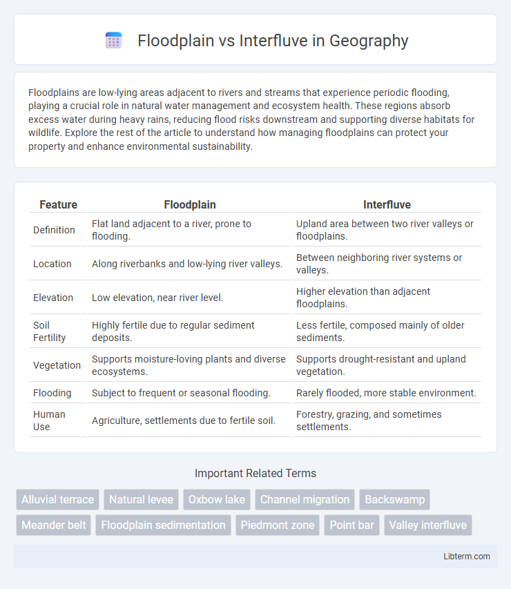
| Feature | Floodplain | Interfluve |
|---|---|---|
| Definition | Flat land adjacent to a river, prone to flooding. | Upland area between two river valleys or floodplains. |
| Location | Along riverbanks and low-lying river valleys. | Between neighboring river systems or valleys. |
| Elevation | Low elevation, near river level. | Higher elevation than adjacent floodplains. |
| Soil Fertility | Highly fertile due to regular sediment deposits. | Less fertile, composed mainly of older sediments. |
| Vegetation | Supports moisture-loving plants and diverse ecosystems. | Supports drought-resistant and upland vegetation. |
| Flooding | Subject to frequent or seasonal flooding. | Rarely flooded, more stable environment. |
| Human Use | Agriculture, settlements due to fertile soil. | Forestry, grazing, and sometimes settlements. |
Introduction to Floodplains and Interfluves
Floodplains are low-lying areas adjacent to rivers and streams that experience periodic flooding, rich in alluvial soils that support diverse ecosystems and agricultural activities. Interfluves are the higher land areas between adjacent river valleys, characterized by well-drained soils and often serving as natural boundaries directing water flow towards floodplains. Understanding the distinct geomorphological features of floodplains and interfluves is essential for effective land use planning, flood management, and ecological conservation.
Definition of Floodplain
A floodplain is the flat or nearly flat land adjacent to a river or stream that experiences occasional or periodic flooding when water overflows from the main channel. This area is characterized by sediment deposits and fertile soil due to regular inundation, supporting diverse ecosystems and agricultural activities. Unlike the interfluve, which is the higher land or ridge between adjacent valleys or river channels, the floodplain is directly shaped by fluvial processes and water dynamics.
Definition of Interfluve
An interfluve is a higher land area or ridge separating adjacent floodplains of different rivers or streams, typically characterized by its elevation above the floodplain and lack of regular flooding. Unlike floodplains, which are flat, low-lying areas prone to seasonal inundation, interfluves serve as natural drainage divides that guide surface water flow between watersheds. Understanding the distinction between interfluves and floodplains is essential for effective watershed management and flood risk assessment.
Formation Processes of Floodplains
Floodplains form through the deposition of alluvial sediments during periodic flooding events along riverbanks, where water velocity decreases, allowing finer particles to settle and create fertile, flat lands. Over time, repeated overflow of rivers erodes banks and redistributes sediments, shaping natural levees, backswamps, and meander scars integral to floodplain morphology. Interfluves, contrastingly, are elevated landforms between adjacent valleys formed primarily by long-term erosion and weathering rather than sediment deposition processes that dominate floodplain formation.
Formation Processes of Interfluves
Interfluves form through the gradual erosion and weathering between adjacent river valleys, where elevated landmasses remain as ridges after rivers carve out the surrounding floodplains. These landforms result from processes such as soil creep, mass wasting, and fluvial incision, shaping the landscape by removing sediment from valley areas while leaving the higher interfluves intact. Interfluves often consist of resistant rock or sediment layers that withstand erosion better than the adjacent floodplains, influencing drainage patterns and watershed boundaries.
Key Physical Differences
Floodplains are flat, low-lying areas adjacent to rivers that experience periodic flooding, characterized by alluvial soil deposits and high soil moisture content. Interfluves are elevated landforms between adjacent river valleys, typically composed of older, more consolidated soils with well-drained conditions, exhibiting limited influence from recent riverine sedimentation. The primary physical distinction lies in floodplains' susceptibility to inundation and sediment deposition versus interfluves' relative elevation and dry, stable terrain.
Ecological Significance
Floodplains, characterized by periodic flooding, support diverse wetland habitats critical for nutrient cycling, sediment deposition, and providing breeding grounds for aquatic and terrestrial species. Interfluves, elevated land areas between rivers, contribute to ecological stability by supporting distinct upland vegetation and serving as refuges during floods, thereby enhancing landscape biodiversity. The spatial interplay between floodplains and interfluves creates habitat heterogeneity essential for maintaining watershed ecological functions and resilience.
Human Settlements and Usage
Floodplains, characterized by flat, fertile land adjacent to rivers, are prime locations for agriculture and urban development due to nutrient-rich soils and accessible water resources. Interfluves, elevated areas between rivers, offer safer grounds for human settlements by reducing flood risks but often lack the fertile soils found in floodplains, limiting intensive farming. Urban planning often balances floodplain advantages with interfluve safety to optimize land use while minimizing flood damage.
Challenges and Risks
Floodplains are highly susceptible to frequent flooding, leading to risks such as soil erosion, habitat loss, and property damage, while interfluves face challenges related to water scarcity and limited groundwater recharge. Floodplains demand rigorous flood management and land-use planning to mitigate economic and environmental impacts. Interfluvial areas often struggle with reduced soil moisture, increasing drought vulnerability and affecting agricultural productivity.
Floodplain vs Interfluve: Summary Comparison
Floodplains are low-lying areas adjacent to rivers, characterized by frequent flooding, rich alluvial soils, and high nutrient availability, supporting diverse ecosystems and agriculture. Interfluves are elevated landforms situated between adjacent river valleys or floodplains, typically composed of older, less fertile soils and serving as drainage divides that influence local hydrology. The primary distinction lies in floodplain susceptibility to flooding and sediment deposition, whereas interfluves remain above flood levels, contributing to watershed separation and landscape stability.
Floodplain Infographic