Geomatics integrates geographic information systems, surveying, and spatial data analysis to accurately capture and interpret the Earth's features. This field supports diverse applications, from urban planning to environmental management, by providing precise geospatial information and mapping solutions. Discover how geomatics can enhance your projects and decision-making by exploring the detailed insights in the rest of this article.
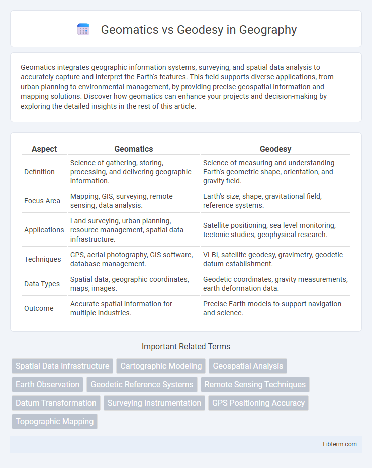
Table of Comparison
| Aspect | Geomatics | Geodesy |
|---|---|---|
| Definition | Science of gathering, storing, processing, and delivering geographic information. | Science of measuring and understanding Earth's geometric shape, orientation, and gravity field. |
| Focus Area | Mapping, GIS, surveying, remote sensing, data analysis. | Earth's size, shape, gravitational field, reference systems. |
| Applications | Land surveying, urban planning, resource management, spatial data infrastructure. | Satellite positioning, sea level monitoring, tectonic studies, geophysical research. |
| Techniques | GPS, aerial photography, GIS software, database management. | VLBI, satellite geodesy, gravimetry, geodetic datum establishment. |
| Data Types | Spatial data, geographic coordinates, maps, images. | Geodetic coordinates, gravity measurements, earth deformation data. |
| Outcome | Accurate spatial information for multiple industries. | Precise Earth models to support navigation and science. |
Introduction to Geomatics and Geodesy
Geomatics encompasses the collection, analysis, and interpretation of geographic data using advanced technologies such as GPS, GIS, and remote sensing to address spatial information challenges. Geodesy, a fundamental subset of geomatics, specializes in measuring and understanding Earth's geometric shape, gravity field, and rotation to provide precise spatial reference frameworks. Both fields integrate spatial data management and earth science principles, with geomatics focusing on applied tools and geodesy emphasizing accurate geospatial measurements and models.
Defining Geomatics: Scope and Applications
Geomatics encompasses the collection, analysis, and interpretation of geographic data through technologies like GIS, remote sensing, and GPS, enabling comprehensive spatial information management. Its scope extends beyond traditional surveying to include data integration, modeling, and visualization for urban planning, environmental monitoring, and resource management. In contrast, geodesy primarily focuses on measuring and understanding Earth's geometric shape, gravity field, and spatial orientation on a global scale.
Geodesy Explained: Core Concepts and Functions
Geodesy involves measuring and understanding Earth's geometric shape, gravitational field, and rotation by using satellite systems, ground surveys, and mathematical models. Core functions include determining precise coordinates for mapping, monitoring tectonic movements, and supporting navigation systems like GPS. Its integration of physics and geometry ensures accurate geospatial data crucial for Earth sciences and engineering projects.
Historical Evolution: Geomatics vs Geodesy
Geomatics originated in the mid-20th century by integrating traditional geodesy with modern surveying, mapping, and spatial data management technologies. Geodesy, one of the oldest Earth sciences dating back to ancient civilizations, primarily focused on measuring and understanding Earth's geometric shape and gravitational field. The evolution from classical geodesy to contemporary geomatics reflects the incorporation of satellite positioning, GIS, and remote sensing, transforming spatial data acquisition and analysis into a multidisciplinary field.
Academic Pathways in Geomatics and Geodesy
Academic pathways in geomatics emphasize multidisciplinary studies combining surveying, geographic information systems (GIS), remote sensing, and spatial data analysis, preparing students for applications in mapping and spatial data management. Geodesy programs focus intensively on the science of Earth's shape, gravity field, and geodynamics, often involving advanced mathematics, physics, and satellite geodesy techniques. Both fields integrate coursework in mathematics and computer science but diverge with geomatics offering broader applications in technology and industry, while geodesy remains more specialized in Earth measurement and geophysical sciences.
Key Technologies in Geomatics and Geodesy
Geomatics integrates advanced technologies such as Geographic Information Systems (GIS), remote sensing, Global Navigation Satellite Systems (GNSS), and laser scanning to capture, store, analyze, and manage spatial data. Geodesy focuses on precise measurement techniques including satellite geodesy, Very Long Baseline Interferometry (VLBI), and gravity field modeling to determine Earth's shape, orientation, and gravitational field. Both fields employ Differential GPS and Inertial Navigation Systems (INS), but geomatics emphasizes data manipulation and application, whereas geodesy prioritizes measurement accuracy and Earth science research.
Practical Applications: Industry Use Cases
Geomatics integrates diverse technologies such as GIS, remote sensing, and GPS for land surveying, urban planning, and environmental management, ensuring precise spatial data collection and analysis. Geodesy specializes in Earth's shape, gravitational field, and dynamic processes, crucial in satellite navigation, tectonic studies, and sea-level monitoring. Industries like construction, mining, and environmental monitoring extensively rely on geomatics for mapping and data integration, while geodesy supports aerospace, geophysics, and climate science through accurate Earth measurement.
Career Opportunities: Comparing Job Prospects
Geomatics offers broader career opportunities in fields like Geographic Information Systems (GIS), remote sensing, and surveying, appealing to professionals interested in technology and data analysis. Geodesy specializes in earth measurement and gravitational studies, providing niche roles in government agencies, research institutions, and satellite monitoring organizations. Both disciplines offer strong demand, but Geomatics generally presents more diverse job prospects across private and public sectors.
Challenges and Future Trends
Geomatics faces challenges in integrating rapidly evolving technologies such as remote sensing, GIS, and AI to handle complex spatial data efficiently, while Geodesy confronts difficulties in achieving ultra-precise Earth measurements due to factors like tectonic shift and atmospheric disturbances. Both fields are moving towards enhanced satellite-based positioning systems, real-time data processing, and the use of machine learning to improve accuracy and predictive modeling. Future trends emphasize the convergence of Geomatics and Geodesy in developing autonomous surveying systems and global digital twins for better environmental monitoring and disaster management.
Conclusion: Choosing Between Geomatics and Geodesy
Selecting between Geomatics and Geodesy depends on the specific needs of a project; Geomatics offers a broader scope integrating data acquisition, analysis, and management for various applications, while Geodesy focuses on high-precision measurement of Earth's shape, gravity, and spatial orientation. Professionals aiming for careers in mapping, remote sensing, and GIS may prefer Geomatics, whereas those interested in satellite positioning, Earth's dynamics, and reference systems gravitate toward Geodesy. Both fields are complementary, with Geodesy's precise measurements underpinning Geomatics' wider spatial data applications.
Geomatics Infographic