A cylindrical shape offers uniform cross-sections along its length, making it ideal for applications requiring consistent strength and volume distribution. This geometric form is commonly used in manufacturing pipes, cans, and mechanical parts due to its efficient structural properties and ease of production. Discover more about the benefits and uses of cylindrical designs in the rest of the article.
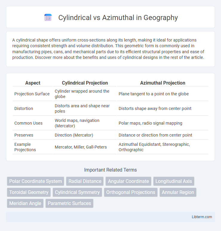
Table of Comparison
| Aspect | Cylindrical Projection | Azimuthal Projection |
|---|---|---|
| Projection Surface | Cylinder wrapped around the globe | Plane tangent to a point on the globe |
| Distortion | Distorts area and shape near poles | Distorts shape away from center point |
| Common Uses | World maps, navigation (Mercator) | Polar maps, radio signal mapping |
| Preserves | Direction (Mercator) | Distance or direction from center point |
| Example Projections | Mercator, Miller, Gall-Peters | Azimuthal Equidistant, Stereographic, Orthographic |
Introduction to Cylindrical and Azimuthal Projections
Cylindrical projections represent the globe by projecting its surface onto a cylinder, maintaining straight meridians and parallels that intersect at right angles, often used for world maps due to their ability to preserve directional relationships. Azimuthal projections project the Earth's surface onto a plane, preserving accurate distances and directions from a central point, making them ideal for polar maps and air route navigation. Each projection serves specific cartographic purposes, balancing distortions in area, shape, distance, or direction according to the map's intended use.
Defining Cylindrical Projections
Cylindrical projections map the Earth's surface onto a cylinder, projecting meridians as equally spaced vertical lines and parallels as horizontal lines, preserving angles but distorting area near the poles. They are widely used in navigation and mapping due to their characteristic rectangular grid, which facilitates accurate direction representation along meridians and parallels. Mercator projection is the most common example, favored for its navigational utility despite significant polar distortion.
Overview of Azimuthal Projections
Azimuthal projections display the Earth's surface from a central point, preserving directions and distances more accurately near this point, often used in polar maps. These projections project points radially outward onto a plane, providing true direction from the center and useful for air navigation and radio mapping. Unlike cylindrical projections, azimuthal maps introduce distortion that increases with distance from the center, making them less suitable for global-scale representations.
Key Differences Between Cylindrical and Azimuthal
Cylindrical projections represent the globe on a rectangular grid where meridians and parallels intersect at right angles, preserving angles but distorting area, especially near the poles. Azimuthal projections map the Earth onto a plane from a single point, accurately representing directions and distances from that center point but distorting shapes and areas farther away. The key difference lies in their geometric basis: cylindrical projections are best for global navigation and mapping equatorial regions, while azimuthal projections excel in polar region mapping and radio communication applications.
Advantages of Cylindrical Projections
Cylindrical projections offer significant advantages in preserving geometric properties over large areas, making them ideal for world maps and navigation. These projections maintain straight meridians and parallels, which simplifies the plotting of routes and coordinates. Their scalability and compatibility with Geographic Information Systems (GIS) enhance spatial data representation and analysis efficiency.
Strengths of Azimuthal Projections
Azimuthal projections excel in preserving accurate distances and directions from a central point, making them ideal for navigation and air route mapping. Their strength lies in representing polar regions and hemispheres with minimal distortion, providing true-scale distances from the center. These projections efficiently display great circle routes as straight lines, enhancing route planning accuracy on global maps.
Typical Applications of Cylindrical Projections
Cylindrical projections are widely used in navigation and world maps where constant direction is essential, such as in the Mercator projection for maritime charts. These projections maintain straight meridians and parallels, making them ideal for compass-based navigation systems and geographic information systems (GIS). Typical applications also include climate mapping and urban planning due to their straightforward grid layout and ability to represent equatorial regions accurately.
Common Uses of Azimuthal Projections
Azimuthal projections are commonly used in aviation and radio communications due to their ability to preserve accurate direction and distance from the central point, making them ideal for flight navigation and signal mapping. These projections also find application in polar region mapping, where their radial symmetry represents areas around the poles with minimal distortion. Unlike cylindrical projections that maintain rectangular grids for global maps, azimuthal projections emphasize central-point accuracy for specialized geographical analyses.
Choosing the Right Projection for Your Needs
Cylindrical projections, such as the Mercator, preserve angles and shapes near the equator but distort size significantly toward the poles, making them ideal for navigation and world maps. Azimuthal projections, like the Lambert azimuthal equal-area, maintain accurate distances and directions from a central point, suitable for regional mapping and air route planning. Selecting the right projection depends on your focus: use cylindrical for global representation with navigational accuracy and azimuthal for true-distance and direction mapping centered on a specific location.
Conclusion: Cylindrical vs Azimuthal Comparison
Cylindrical map projections preserve distance and direction along the equator, making them ideal for navigation and equatorial regions, while azimuthal projections maintain true direction from a central point, useful for air route mapping and polar areas. Cylindrical projections often distort size and shape near the poles, whereas azimuthal projections exhibit distortion increasing with distance from the center. The choice between cylindrical and azimuthal depends on the specific mapping purpose, geographic focus, and the importance of preserving angular relationships or area fidelity.
Cylindrical Infographic