Goode's Homolosine projection minimizes distortion by combining the sinusoidal and Mollweide projections, providing an accurate representation of landmasses with interrupted oceans. This map is particularly useful for displaying global data related to vegetation, climate, and population without compromising spatial relationships. Explore the article to discover how You can leverage Goode's Homolosine projection for more precise geographic analysis.
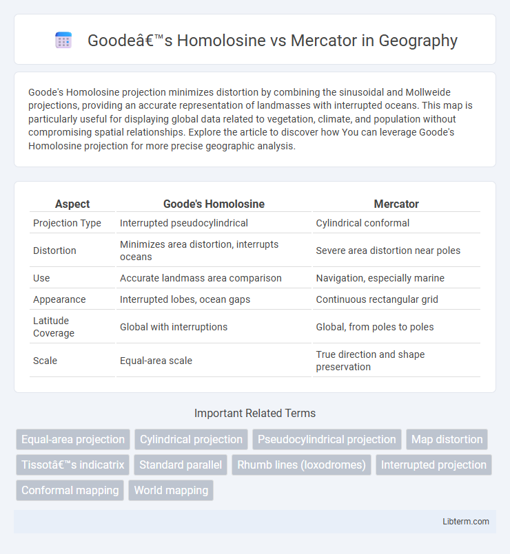
Table of Comparison
| Aspect | Goode's Homolosine | Mercator |
|---|---|---|
| Projection Type | Interrupted pseudocylindrical | Cylindrical conformal |
| Distortion | Minimizes area distortion, interrupts oceans | Severe area distortion near poles |
| Use | Accurate landmass area comparison | Navigation, especially marine |
| Appearance | Interrupted lobes, ocean gaps | Continuous rectangular grid |
| Latitude Coverage | Global with interruptions | Global, from poles to poles |
| Scale | Equal-area scale | True direction and shape preservation |
Introduction to Goode’s Homolosine and Mercator Projections
Goode's Homolosine projection combines the Sinusoidal and Mollweide projections to minimize distortion in area representation, providing a more accurate view of global landmasses. The Mercator projection, originally designed for nautical navigation, preserves angles and shapes but significantly distorts size, especially near the poles. Goode's Homolosine is ideal for thematic world maps highlighting spatial relationships, while Mercator remains popular for navigation and web mapping despite its size distortions.
Historical Background of Map Projections
Goode's Homolosine projection, developed by John Paul Goode in 1923, emerged to reduce distortion by combining the Sinusoidal and Mollweide projections, addressing the limitations of traditional projections in representing global landmasses accurately. The Mercator projection, created by Gerardus Mercator in 1569, was initially designed for navigational purposes, preserving angles and directions but significantly distorting size, especially near the poles. These contrasting historical origins reflect differing priorities in cartography: Goode's Homolosine prioritizes area accuracy and minimizing distortion, while Mercator focuses on navigation and angular conformity.
Key Features of the Goode’s Homolosine Projection
Goode's Homolosine projection minimizes distortion by combining the Sinusoidal and Mollweide projections, preserving area relationships across continents. Its interrupted format reduces shape distortion, particularly in landmasses, making it ideal for thematic and distribution maps. This projection excels in representing global spatial data accurately without sacrificing relative proportions, unlike the Mercator projection, which distorts size near the poles.
Defining Characteristics of the Mercator Projection
The Mercator projection is a cylindrical map projection known for preserving accurate compass bearings, making it essential for maritime navigation. It distorts size, especially near the poles, causing landmasses like Greenland and Antarctica to appear disproportionately large. Its grid of straight meridians and parallels intersecting at right angles facilitates navigational charting, though it sacrifices area accuracy for angular conformity.
Map Distortion: Shape, Area, and Distance
Goode's Homolosine projection minimizes area distortion by using interruptions that preserve relative landmass sizes, making it ideal for thematic maps requiring accurate area representation. The Mercator projection significantly distorts area, especially near the poles, where landmasses appear much larger than they are in reality, but it preserves angles and shapes well, which benefits navigation. Distance distortion occurs in Goode's Homolosine projection due to its interrupted design, disrupting continuous distances, whereas the Mercator projection maintains consistent distance scale along the equator but exaggerates distances as one moves towards the poles.
Applications and Usage in Cartography
Goode's Homolosine projection excels in minimizing distortion for global thematic maps, especially in representing landmasses accurately by interrupting oceans to preserve area proportions. It is widely used in educational and environmental mapping where true area representation is critical for analyzing spatial data. The Mercator projection remains the standard for nautical navigation due to its ability to represent lines of constant compass bearing as straight segments, despite its significant distortion of size at higher latitudes.
Advantages of Goode’s Homolosine Projection
Goode's Homolosine projection minimizes distortion of landmasses by combining the Mollweide and sinusoidal projections, preserving area accuracy across continents. It effectively represents global spatial relationships, making it particularly advantageous for thematic and environmental maps that require precise area comparison. Unlike the Mercator projection, which significantly distorts size near the poles, Goode's Homolosine provides a more balanced and realistic view of Earth's surface.
Benefits and Drawbacks of the Mercator Projection
The Mercator projection preserves accurate angles and shapes, making it ideal for marine navigation and mapping equatorial regions. However, it significantly distorts size, especially near the poles, exaggerating the area of continents like Greenland and Antarctica. This distortion can mislead perceptions of geographic size and spatial relationships on a global scale.
Choosing the Right Projection for Geographic Visualization
Goode's Homolosine projection minimizes distortion by interrupting oceans and preserving area, making it ideal for thematic maps emphasizing spatial distribution and landmass relationships. Mercator projection maintains accurate angles and shapes, favoring navigation and applications requiring conformal properties but significantly distorts size near the poles. Selecting between Goode's Homolosine and Mercator depends on visualization goals: choose Goode's for accurate area representation and Mercator for directional precision in geographic data display.
Conclusion: Goode’s Homolosine vs Mercator in Modern Mapping
Goode's Homolosine projection reduces distortion by combining equal-area properties, making it ideal for thematic and environmental maps, whereas Mercator's projection preserves angles and shapes for accurate navigation but exaggerates areas near the poles. Modern mapping benefits from Goode's Homolosine in representing global data without area distortion, while Mercator remains dominant in marine and air navigation due to its conformal nature. Choosing between these projections depends on the purpose, with Goode's excelling in spatial analysis and Mercator in orientation and route planning.
Goode’s Homolosine Infographic