An erosional surface forms when natural forces like wind, water, or ice remove soil and rock layers, reshaping the Earth's landscape over time. This process reveals underlying strata and influences soil fertility, land stability, and ecosystem development. Discover how erosional surfaces impact your environment and their significance in geology by reading the full article.
Table of Comparison
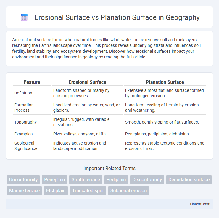
| Feature | Erosional Surface | Planation Surface |
|---|---|---|
| Definition | Landform shaped primarily by erosion processes. | Extensive almost flat land surface formed by prolonged erosion. |
| Formation Process | Localized erosion by water, wind, or glaciers. | Long-term leveling of terrain by erosion and weathering. |
| Topography | Irregular, rugged, with variable elevations. | Smooth, gently sloping or flat surfaces. |
| Examples | River valleys, canyons, cliffs. | Peneplains, pediplains, etchplains. |
| Geological Significance | Indicates active erosion and landscape modification. | Represents stable tectonic conditions and erosion climax. |
Introduction: Defining Erosional and Planation Surfaces
Erosional surfaces are landforms created by the removal of soil and rock through natural processes such as water, wind, and glacial activity, resulting in uneven and rugged terrain. Planation surfaces represent nearly level landforms formed by extensive erosion that reduces elevated areas to flat or gently undulating plains. Understanding the distinction between erosional and planation surfaces is essential for interpreting landscape evolution and geological history.
Geological Formation Processes
Erosional surfaces form through the removal of rock and soil by agents such as water, wind, and ice, creating irregular landforms shaped by differential erosion rates. Planation surfaces develop over geological timescales via extensive weathering and denudation, resulting in broad, nearly level landforms like peneplains or pediplains. The contrasting formation processes highlight erosional surfaces as more localized and uneven, while planation surfaces represent large-scale, progressive leveling of the landscape.
Key Characteristics of Erosional Surfaces
Erosional surfaces are characterized by irregular topography resulting from differential weathering and erosion, exposing resistant rock layers and creating features such as cliffs, valleys, and escarpments. These surfaces often exhibit unconformities where varying rock strata are truncated, indicating episodes of significant material removal. Unlike planation surfaces, which are relatively flat and formed by long-term denudation, erosional surfaces retain distinct relief patterns shaped by mechanical and chemical processes.
Key Characteristics of Planation Surfaces
Planation surfaces are extensive, nearly level landforms created primarily by prolonged erosion and weathering processes that reduce relief over geological time. They differ from erosional surfaces, which may exhibit more irregular topography due to localized erosion. Key characteristics of planation surfaces include their broad spatial extent, gently undulating or flat morphology, and formation through the balance of denudation and uplift that leads to a stable, low-relief landscape.
Differences in Origin and Development
Erosional surfaces form through the removal of rock and soil by natural agents such as water, wind, or ice, resulting in features like valleys and ravines shaped over relatively shorter geological timescales. Planation surfaces emerge from prolonged and extensive weathering and denudation, leading to gently undulating or nearly level landforms like peneplains, reflecting advanced stages of landscape evolution. The key difference lies in erosional surfaces being products of active removal processes, whereas planation surfaces represent stabilized, near-equilibrium stages of landscape reduction.
Geomorphological Significance
Erosional surfaces represent irregular landforms shaped by differential weathering and erosion, revealing varying rock resistances and geological structures, while planation surfaces are extensive, nearly flat or gently undulating terrains formed through prolonged erosion and sediment removal. The geomorphological significance of erosional surfaces lies in their indication of active tectonics and landscape evolution, showcasing processes like valley incision and ridge retreat. Planation surfaces signify a stage of geomorphic stability and equilibrium, often marking ancient peneplains or pediplains that serve as benchmarks for understanding long-term landscape denudation and base-level changes.
Examples and Global Distribution
Erosional surfaces such as peneplains and pediments are commonly found in arid and semi-arid regions like the Southwestern United States, showcasing extensive removal of material through weathering and erosion processes. Planation surfaces, including etchplains and pediplains, occur widely in tropical and subtropical zones, such as parts of Africa and Australia, formed by long-term leveling and weathering under stable tectonic conditions. Notable examples include the Scandinavian peneplain and the African etchplain, illustrating diverse geomorphological processes and climatic influences on the global distribution of these landforms.
Role in Landscape Evolution
Erosional surfaces form through the removal of rock and soil by agents like water, wind, or ice, shaping valleys and rugged terrains essential for landscape diversification. Planation surfaces develop from prolonged weathering and uniform erosion, creating nearly level or gently undulating landforms that signify advanced stages of landscape maturity. Both surfaces demonstrate critical processes in landscape evolution, with erosional surfaces highlighting active dissection and planation surfaces representing landscape stabilization and denudation.
Methods of Identification and Study
Erosional surfaces are identified through morphological analysis via field surveys, revealing distinct relief contrasts, while planation surfaces are recognized by their extensive flatness using remote sensing techniques such as satellite imagery and digital elevation models (DEMs). Geomorphologists employ stratigraphic studies and cosmogenic nuclide dating to determine the chronological framework of erosional surfaces, whereas planation surfaces are studied through sedimentological analysis and geophysical methods to assess the extent and uniformity of weathering and erosion processes. Integration of GIS-based topographic metrics enhances the precision of mapping both erosional and planation surfaces, facilitating detailed landscape evolution modeling.
Summary: Erosional Surface vs Planation Surface
Erosional surfaces are landforms shaped primarily by the removal of soil and rock through processes like weathering, water flow, and wind, resulting in irregular terrain with variable elevations. In contrast, planation surfaces represent nearly flat or gently undulating landscapes formed by prolonged erosion and leveling, often serving as peneplains or pediplains. Understanding their differences helps in interpreting geological history and landscape evolution, as erosional surfaces reflect active erosive forces while planation surfaces indicate prolonged stability and erosion.
Erosional Surface Infographic