Floodplains are low-lying areas adjacent to rivers and streams that serve as natural buffers during periods of high water flow, significantly reducing flood risks by absorbing excess water. These fertile lands support diverse ecosystems and offer opportunities for sustainable agriculture and recreation. Explore the rest of the article to understand how managing your floodplain can protect communities and enhance environmental health.
Table of Comparison
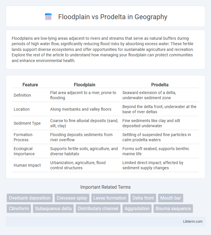
| Feature | Floodplain | Prodelta |
|---|---|---|
| Definition | Flat area adjacent to a river, prone to flooding | Seaward extension of a delta, underwater sediment zone |
| Location | Along riverbanks and valley floors | Beyond the delta front, underwater at the base of river deltas |
| Sediment Type | Coarse to fine alluvial deposits (sand, silt, clay) | Fine sediments like clay and silt deposited underwater |
| Formation Process | Flooding deposits sediments from river overflow | Settling of suspended fine particles in calm prodelta waters |
| Ecological Importance | Supports fertile soils, agriculture, and diverse habitats | Forms soft seabed, supports benthic marine life |
| Human Impact | Urbanization, agriculture, flood control structures | Limited direct impact; affected by sediment supply changes |
Introduction to Floodplain and Prodelta
Floodplains are flat, low-lying areas adjacent to rivers, formed by sediment deposits during flooding events and characterized by fertile soils supporting diverse ecosystems. Prodelta refers to the underwater extension of a delta, where fine sediments settle in deeper, calmer waters beyond the delta front, creating a distinct depositional environment. Understanding the contrasting sedimentary processes and environments of floodplains and prodelta regions is crucial for managing riverine and coastal landscapes effectively.
Key Definitions: Floodplain and Prodelta
A floodplain is a flat, low-lying area adjacent to a river or stream that experiences periodic flooding, playing a crucial role in sediment deposition and nutrient distribution. The prodelta is the underwater extension of a delta, located seaward of the delta front, where fine sediments settle from suspension in deeper, calmer waters. Both floodplains and prodelta zones are essential in shaping sedimentary environments and supporting diverse ecological habitats.
Formation Processes of Floodplains
Floodplains form through sediment deposition during river overflows, where fine particles settle as water velocity decreases on flat valley floors, creating fertile land. Sediment stratification and soil development result from periodic flooding, influencing floodplain morphology and ecosystem structure. Unlike prodelta regions formed by marine sediment accumulation at river mouths, floodplains primarily develop from fluvial processes and alluvial deposits.
Formation Processes of Prodelta
The prodelta forms through the gradual settling of fine sediments like silt and clay carried by river currents into deeper, low-energy marine environments beyond the delta front. These sediments accumulate over time due to reduced water velocity, resulting in stratified, horizontally layered deposits that extend seaward from the delta. Floodplains, in contrast, develop inland via fluvial overbank flows depositing coarser materials during seasonal flooding events.
Sediment Characteristics: Floodplain vs Prodelta
Floodplains consist primarily of fine to medium-grained sediments such as silts and clays, deposited by overbank flooding, resulting in highly fertile and well-sorted layers. Prodelta sediments are typically finer, dominated by organic-rich clays and muds that settle from suspension in the quiet, offshore environment. The floodplain deposits tend to show more variability due to episodic flooding, whereas prodelta sediments accumulate more steadily in a low-energy setting.
Ecological Functions and Biodiversity
Floodplains serve as crucial ecological buffers by filtering pollutants, providing habitat for diverse terrestrial and aquatic species, and supporting nutrient cycling through periodic flooding. Prodelta environments, located at the base of river deltas, offer unique sedimentary habitats that sustain benthic biodiversity and serve as nurseries for various fish and invertebrate species. Both floodplains and prodelta zones contribute significantly to regional biodiversity and ecosystem productivity by maintaining habitat heterogeneity and supporting complex food webs.
Hydrological Dynamics and Water Flow
Floodplains exhibit complex hydrological dynamics characterized by seasonal flooding, where water flow spreads laterally over flat terrains, promoting nutrient deposition and sediment distribution. In contrast, prodelta environments experience sediment-laden water flow primarily directed seaward, with fine particles settling from suspension as flow velocity decreases near the delta front. The interaction of water flow regimes in both floodplains and prodelta zones critically influences sediment transport, deposition patterns, and aquatic habitat formation.
Geomorphological Differences
Floodplains are relatively flat areas adjacent to rivers, formed by sediment deposition during periodic flooding, characterized by fine-grained alluvial soils and meandering channels. Prodelta regions lie offshore at the base of river deltas, shaped by the settling of fine sediments in deeper, quieter waters, resulting in stratified, typically marine-influenced deposits. Geomorphologically, floodplains feature active channel migration and frequent sediment renewal, whereas prodelta environments accumulate layered sediments under more stable hydrodynamic conditions.
Human Impacts and Management Considerations
Floodplains, characterized by periodic river flooding, face significant human impacts such as urban development, agriculture, and infrastructure construction that alter natural flooding regimes and reduce biodiversity. Prodelta regions, located offshore at river mouths, are affected by sediment trapping from upstream damming and pollution runoff, which disrupt sediment deposition and aquatic ecosystem health. Effective management requires integrated watershed approaches, including sustainable land use planning on floodplains and sediment management practices to maintain deltaic processes and protect coastal habitats.
Summary of Key Differences and Similarities
Floodplain and prodelta are distinct geomorphological features formed by sediment deposition but differ in location and sediment characteristics. Floodplains are flat areas adjacent to rivers, composed mainly of fine silts and clays deposited during periodic flooding, while prodelta refers to the part of a delta directly seaward of the river mouth, characterized by finer sediments settling from suspension in low-energy marine environments. Both environments act as sediment sinks and support rich ecosystems, but floodplains primarily experience fluvial processes, whereas prodelta regions are shaped by a combination of fluvial and marine dynamics.
Floodplain Infographic