Centripetal drainage is a pattern where rivers and streams flow inward toward a central basin or depression, often forming a circular or radial network. This drainage system typically develops in areas with a topographic basin, like volcanic craters or salt pans, where water converges into a single low point. Explore this article to understand how centripetal drainage shapes landscapes and impacts your environmental observations.
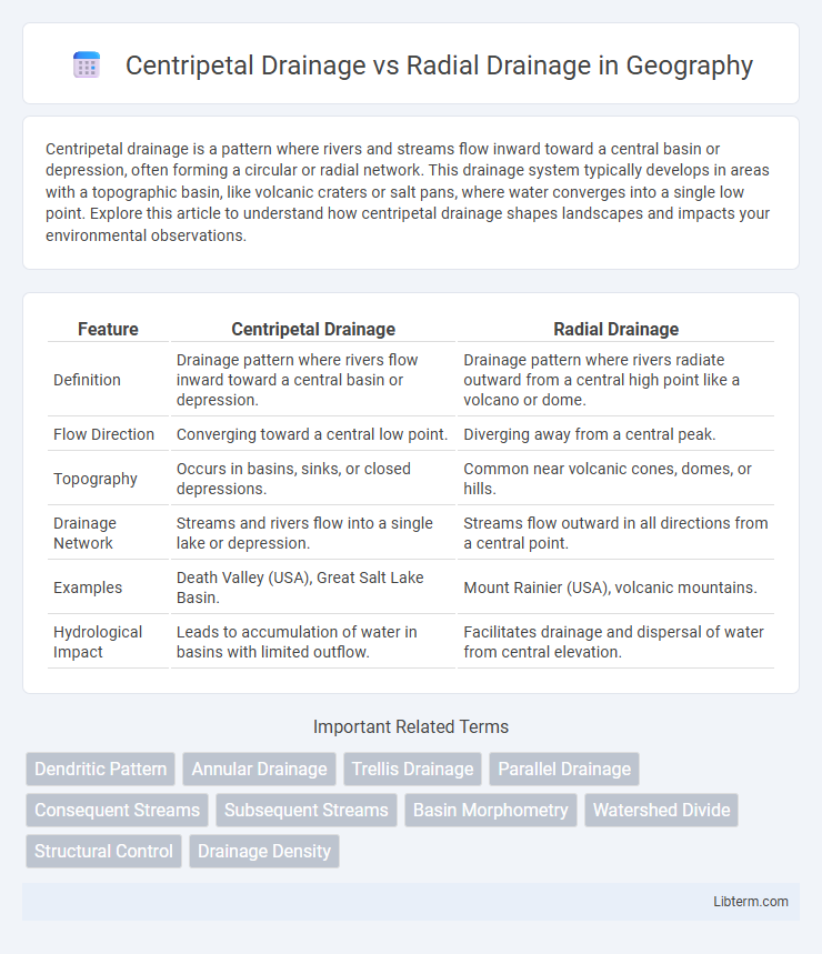
Table of Comparison
| Feature | Centripetal Drainage | Radial Drainage |
|---|---|---|
| Definition | Drainage pattern where rivers flow inward toward a central basin or depression. | Drainage pattern where rivers radiate outward from a central high point like a volcano or dome. |
| Flow Direction | Converging toward a central low point. | Diverging away from a central peak. |
| Topography | Occurs in basins, sinks, or closed depressions. | Common near volcanic cones, domes, or hills. |
| Drainage Network | Streams and rivers flow into a single lake or depression. | Streams flow outward in all directions from a central point. |
| Examples | Death Valley (USA), Great Salt Lake Basin. | Mount Rainier (USA), volcanic mountains. |
| Hydrological Impact | Leads to accumulation of water in basins with limited outflow. | Facilitates drainage and dispersal of water from central elevation. |
Introduction to Drainage Patterns
Drainage patterns describe the spatial arrangement of river channels shaped by geology, slope, and climate factors. Centripetal drainage features streams converging inward toward a central basin or depression, commonly found in arid or tectonically influenced regions. Radial drainage displays streams radiating outward from a central high point, such as a volcanic cone or dome, reflecting symmetrical slope gradients.
Defining Centripetal Drainage
Centripetal drainage is characterized by streams and rivers converging inward toward a central basin or depression, often found in areas with closed topography like basins or volcanic craters. This drainage pattern contrasts with radial drainage, where water flows outward in all directions from a central elevated point such as a volcano or dome. The centripetal system plays a crucial role in collecting surface runoff and directing it to a single sink, affecting sediment deposition and local hydrology.
Defining Radial Drainage
Radial drainage refers to a pattern where rivers or streams flow outward from a central high point, such as a volcano or dome, resembling the spokes of a wheel. It contrasts with centripetal drainage, where water converges toward a central basin or depression. Radial drainage systems are common in volcanic regions and result from topographic elevation radiating water flow in multiple directions.
Key Characteristics of Centripetal Drainage
Centripetal drainage systems are characterized by streams converging inward toward a central basin or depression, often found in closed basins such as playas or salt flats. These drainage patterns typically develop in arid or semi-arid regions where water collects in a central low point without an outlet, leading to water accumulation and potential evaporation. The arrangement differs distinctly from radial drainage, where streams flow outward from a central high point like a volcano or dome.
Key Characteristics of Radial Drainage
Radial drainage features streams that flow outward from a central elevated point, such as a volcanic cone or dome, radiating in all directions like spokes on a wheel. This drainage pattern typically develops on conical landforms where water disperses uniformly, facilitating efficient surface runoff. Radial drainage systems are characterized by their symmetrical arrangement and are commonly found in volcanic regions and dome-shaped hills.
Formation Processes: Centripetal vs Radial
Centripetal drainage forms when water converges inward toward a central basin, typically in areas with topographic depressions like playas or inland drainage basins, causing streams to flow toward a common low point. Radial drainage develops around a central elevated point such as a volcano or dome, where streams flow outward in all directions from the peak due to gravity acting on the symmetrical slope. The key difference lies in centripetal systems draining inward to a basin, while radial systems radiate outward from a high point.
Geographical Examples of Centripetal Drainage
Centripetal drainage patterns develop where rivers flow inward toward a central basin or depression, commonly found in endorheic basins such as the Dead Sea basin in the Jordan Rift Valley and the Great Salt Lake basin in Utah, USA. These drainage systems are typical in arid and semi-arid regions where evaporation exceeds precipitation, preventing outflow to external rivers or oceans. The structural control of surrounding topography guides the water accumulation, influencing sediment deposit patterns and local ecosystem dynamics.
Geographical Examples of Radial Drainage
Radial drainage patterns develop when rivers flow outward from a central elevated point, such as volcanic cones or domes, exemplified by the radial drainage observed around Mount Kilimanjaro in Tanzania and the Deccan Plateau's basaltic plateaus in India. These rivers radiate away from the summit, shaping the landscape through erosion and sediment transport. Radial drainage contrasts with centripetal drainage, where streams converge into a central basin or depression.
Environmental Implications of Drainage Patterns
Centripetal drainage systems concentrate water flow towards a central basin, influencing localized water accumulation and potentially increasing flood risks and sediment deposition in enclosed areas. Radial drainage patterns, emanating from a central elevated point, promote outward water dispersion which can enhance soil erosion on slopes and affect downstream sediment transport. Understanding these patterns is crucial for managing watershed hydrology, predicting flood zones, and planning sustainable land use to minimize environmental degradation.
Comparative Analysis: Centripetal vs Radial Drainage
Centripetal drainage features streams converging towards a central basin, often found in closed topographic depressions or crater lakes, while radial drainage exhibits streams radiating outward from a central high point such as a volcano or dome. The key comparison lies in flow directionality: centripetal drainage collects water inward, promoting sediment accumulation, whereas radial drainage disperses water away, enhancing erosion. These contrasting patterns influence landscape evolution and hydrological characteristics, with centripetal systems favoring interior drainage basins and radial systems shaping outward-facing slopes.
Centripetal Drainage Infographic