GIS enhances decision-making by integrating, analyzing, and visualizing spatial data for diverse applications such as urban planning, environmental management, and logistics. The technology allows you to uncover patterns and relationships that traditional data analysis might overlook. Explore the rest of the article to understand how GIS can transform your approach to data and problem-solving.
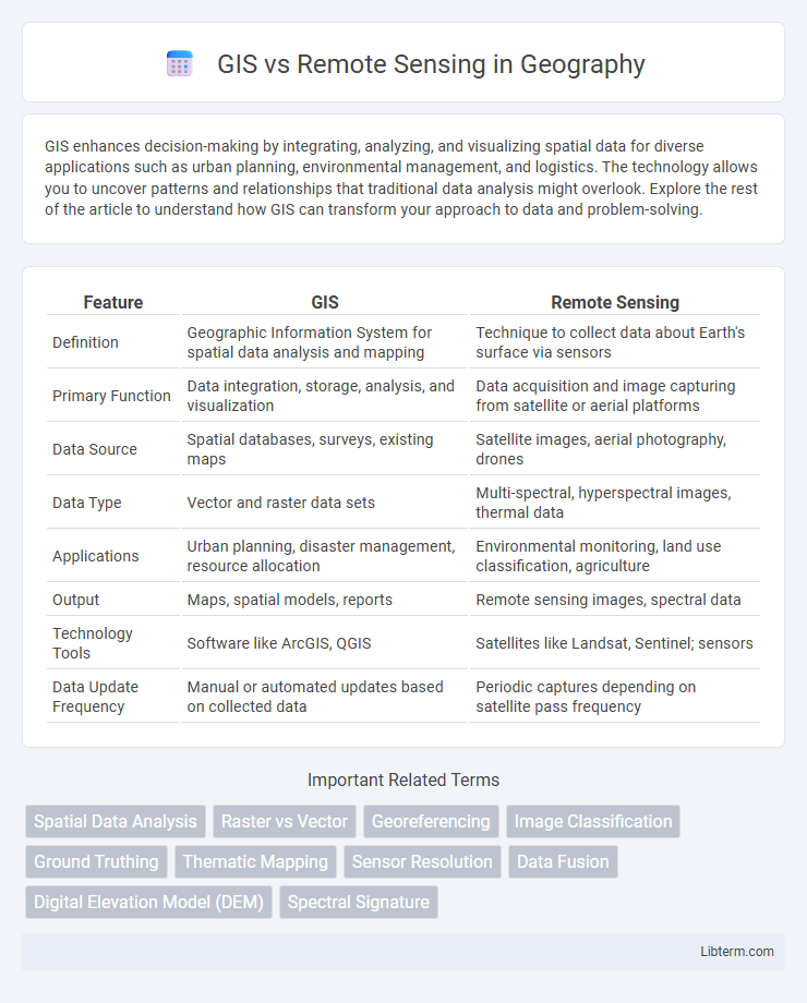
Table of Comparison
| Feature | GIS | Remote Sensing |
|---|---|---|
| Definition | Geographic Information System for spatial data analysis and mapping | Technique to collect data about Earth's surface via sensors |
| Primary Function | Data integration, storage, analysis, and visualization | Data acquisition and image capturing from satellite or aerial platforms |
| Data Source | Spatial databases, surveys, existing maps | Satellite images, aerial photography, drones |
| Data Type | Vector and raster data sets | Multi-spectral, hyperspectral images, thermal data |
| Applications | Urban planning, disaster management, resource allocation | Environmental monitoring, land use classification, agriculture |
| Output | Maps, spatial models, reports | Remote sensing images, spectral data |
| Technology Tools | Software like ArcGIS, QGIS | Satellites like Landsat, Sentinel; sensors |
| Data Update Frequency | Manual or automated updates based on collected data | Periodic captures depending on satellite pass frequency |
Introduction to GIS and Remote Sensing
Geographic Information Systems (GIS) and Remote Sensing are pivotal technologies for spatial data collection, analysis, and visualization. GIS integrates hardware, software, and data for capturing, managing, and analyzing geographic information, enabling detailed mapping and decision-making. Remote Sensing involves acquiring information about the Earth's surface through satellite or aerial sensors, providing essential data that enhances GIS applications in environmental monitoring, urban planning, and resource management.
Defining GIS: Core Concepts and Applications
Geographic Information Systems (GIS) are computer-based tools that capture, store, analyze, and visualize spatial or geographic data for decision-making and resource management. Core concepts of GIS include spatial data models, geodatabases, spatial analysis, and cartographic visualization, enabling applications in urban planning, environmental monitoring, and disaster management. Unlike remote sensing, which primarily involves data acquisition through satellite or aerial sensors, GIS integrates diverse datasets to perform complex spatial analyses and generate actionable insights.
What is Remote Sensing? Key Principles and Uses
Remote sensing is the technique of acquiring information about Earth's surface without direct contact, using sensors on satellites or aircraft to detect and measure reflected or emitted electromagnetic radiation. Key principles include sensor resolution, spectral bands, and the interpretation of data for analysis of land use, vegetation, climate change, and natural disaster monitoring. Remote sensing is essential for environmental monitoring, agriculture management, urban planning, and disaster response due to its ability to provide timely, large-scale data.
Data Acquisition in GIS vs Remote Sensing
GIS acquires data primarily through field surveys, GPS measurements, and existing spatial databases, enabling detailed attribute information linked to specific locations. Remote sensing collects data via satellite sensors, aerial photography, and drones, capturing large-scale, multi-spectral imagery that reveals surface characteristics and changes over time. While GIS emphasizes integrating diverse data types for spatial analysis, remote sensing focuses on continuous, broad-area data acquisition through electromagnetic spectrum detection.
Tools and Technologies: Comparing GIS and Remote Sensing
GIS utilizes software like ArcGIS and QGIS to analyze spatial data through layers, enabling complex mapping and spatial queries. Remote sensing relies on satellite platforms and sensors such as Landsat, Sentinel, and LiDAR to capture real-time earth surface data across various spectral bands. Integrating GIS with remote sensing enhances geospatial analysis by combining detailed imagery with robust spatial data management tools.
Spatial Analysis: How GIS Differs from Remote Sensing
GIS excels in spatial analysis by integrating diverse datasets to model, visualize, and interpret geographic patterns and relationships, enabling complex decision-making processes. Remote sensing primarily acquires raw spatial data through satellite or aerial imagery but lacks the advanced analytical tools inherent in GIS. While remote sensing supplies critical information layers, GIS processes and analyzes these layers to produce actionable insights.
Real-World Applications: GIS vs Remote Sensing
GIS enables spatial data analysis for urban planning, disaster management, and environmental monitoring, providing precise mapping and decision-making tools. Remote sensing offers real-time data collection through satellite or aerial imagery, crucial for agriculture monitoring, deforestation tracking, and climate change studies. Integrating GIS and remote sensing enhances comprehensive geospatial insights, optimizing resource management and policy implementation.
Integration of GIS and Remote Sensing for Enhanced Results
The integration of GIS and Remote Sensing leverages satellite imagery and spatial data analysis to enhance environmental monitoring, urban planning, and resource management. Remote sensing provides accurate, real-time data acquisition, while GIS enables complex spatial modeling and visualization, facilitating informed decision-making. Combining these technologies improves data accuracy, temporal resolution, and comprehensive insights critical for disaster management, agriculture, and land-use planning.
Pros and Cons: GIS Compared to Remote Sensing
GIS excels in spatial data management, analysis, and visualization, offering robust tools for mapping, querying, and integrating diverse datasets, but its effectiveness depends on the quality and availability of input data. Remote sensing provides timely, large-scale environmental monitoring using satellite or aerial imagery, capturing real-time changes across vast areas, though it often requires complex processing and may suffer from resolution or atmospheric limitations. Combining GIS with remote sensing enhances decision-making by leveraging GIS's analytical capabilities and remote sensing's up-to-date data acquisition, despite challenges in data compatibility and integration complexity.
Future Trends in GIS and Remote Sensing Technologies
Future trends in GIS and Remote Sensing technologies emphasize the integration of AI and machine learning for enhanced spatial data analysis and predictive modeling. The advancement in real-time data acquisition through drones and satellite constellations is driving unprecedented accuracy and temporal resolution. Cloud computing and big data analytics further enable scalable processing and collaborative geospatial intelligence, transforming decision-making across environmental monitoring and urban planning.
GIS Infographic