Subsidence occurs when the ground beneath a structure sinks or shifts, causing significant damage to buildings and infrastructure. This phenomenon can result from natural processes like soil compaction or human activities such as mining and groundwater extraction. Explore the rest of this article to understand how subsidence may affect your property and the measures you can take to prevent it.
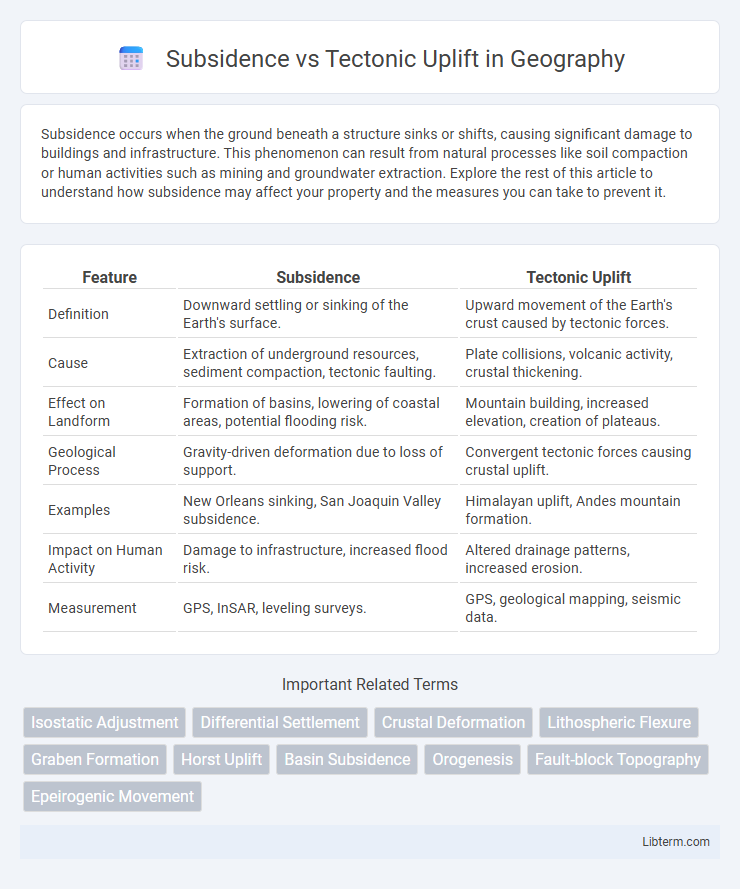
Table of Comparison
| Feature | Subsidence | Tectonic Uplift |
|---|---|---|
| Definition | Downward settling or sinking of the Earth's surface. | Upward movement of the Earth's crust caused by tectonic forces. |
| Cause | Extraction of underground resources, sediment compaction, tectonic faulting. | Plate collisions, volcanic activity, crustal thickening. |
| Effect on Landform | Formation of basins, lowering of coastal areas, potential flooding risk. | Mountain building, increased elevation, creation of plateaus. |
| Geological Process | Gravity-driven deformation due to loss of support. | Convergent tectonic forces causing crustal uplift. |
| Examples | New Orleans sinking, San Joaquin Valley subsidence. | Himalayan uplift, Andes mountain formation. |
| Impact on Human Activity | Damage to infrastructure, increased flood risk. | Altered drainage patterns, increased erosion. |
| Measurement | GPS, InSAR, leveling surveys. | GPS, geological mapping, seismic data. |
Introduction to Subsidence and Tectonic Uplift
Subsidence is the gradual sinking or settling of the Earth's surface often caused by natural processes like the compaction of sediment, groundwater extraction, or tectonic activity. Tectonic uplift refers to the vertical elevation of the Earth's crust resulting from tectonic forces such as plate collisions, faulting, or volcanic activity. Understanding the distinctions between subsidence and tectonic uplift is crucial for assessing geological hazards and landscape evolution.
Defining Subsidence: Causes and Processes
Subsidence refers to the gradual sinking or downward settling of the Earth's surface, primarily caused by natural processes such as sediment compaction, groundwater extraction, mining activities, and tectonic movements. This phenomenon results from the reduction of support beneath the ground, including the collapse of underground voids or the consolidation of soil and rock layers. Subsidence can significantly impact infrastructure, groundwater systems, and ecosystem stability by altering land elevation and surface drainage patterns.
Understanding Tectonic Uplift Mechanisms
Tectonic uplift occurs when Earth's crust is raised due to plate tectonic forces such as faulting, folding, and volcanic activity, in contrast to subsidence, which involves the sinking of the ground. Mechanisms driving tectonic uplift include convergent plate boundaries where compression causes mountain building, and isostatic rebound following erosion or glacial melting. Understanding these processes is critical for assessing landscape evolution, seismic hazards, and regional geological stability.
Geological Evidence of Subsidence
Geological evidence of subsidence includes sediment compaction, fault displacement, and stratigraphic records indicating vertical ground lowering over time. Coastal and deltaic sediment layers often show signs of gradual sinking, supported by borehole data and seismic surveys revealing subsurface deformation. Radiocarbon dating of organic materials within subsiding basins helps quantify rates of subsidence linked to tectonic or anthropogenic factors.
Signs and Features of Tectonic Uplift
Tectonic uplift is characterized by features such as raised fault scarps, tilted rock layers, and elevated landforms like mountains and plateaus. Signs include the exposure of older rocks above younger strata, river terraces that indicate changes in base level, and the presence of mountain ranges formed by crustal shortening and thickening. These features contrast with subsidence, which typically involves land sinking and the development of basins or depressions.
Human Impact and Interaction with Subsidence
Subsidence, often caused by groundwater extraction, mining, and oil drilling, leads to ground sinking that damages infrastructure, reduces land usability, and increases flood risk in urban areas. Human activities accelerating subsidence exacerbate soil compaction and alter natural drainage patterns, affecting water management systems and agricultural productivity. In contrast, tectonic uplift, driven by geological forces, reshapes landscapes but is less directly influenced by human intervention, though its impacts on land stability can still interact with engineering and construction practices.
Ecological and Environmental Effects of Uplift
Tectonic uplift significantly alters ecosystems by changing land elevation, which reshapes drainage patterns and creates new habitats for diverse flora and fauna. It often leads to increased erosion and sediment transport, impacting water quality and aquatic environments. Uplift areas can enhance biodiversity by exposing fresh rock surfaces and forming varied microclimates essential for species adaptation and ecological succession.
Subsidence vs. Uplift: Key Differences Explained
Subsidence involves the gradual sinking or settling of the Earth's surface due to natural processes like sediment compaction, groundwater extraction, or tectonic activity, resulting in a decrease in elevation. Tectonic uplift, on the other hand, is the process where land is raised due to plate tectonics, such as mountain building or fault movements, causing an increase in elevation. The key difference lies in their opposite vertical movements: subsidence lowers land elevation, while tectonic uplift elevates it, impacting geological formations and human infrastructure differently.
Case Studies: Notable Examples Worldwide
Subsidence and tectonic uplift present contrasting geological processes reshaping Earth's crust, with notable case studies illustrating their impact. The Mississippi Delta in the United States exemplifies subsidence driven by sediment compaction and hydrocarbon extraction, causing increased flood risk and coastal erosion. In contrast, the Himalayan orogeny demonstrates tectonic uplift resulting from the collision of the Indian and Eurasian plates, elevating mountain ranges and affecting regional climate and biodiversity patterns.
Conclusion: Managing and Monitoring Land Elevation Changes
Effective management of land elevation changes hinges on continuous monitoring through satellite geodesy, GPS, and InSAR technologies that detect both subsidence and tectonic uplift with high precision. Integrating geological data with real-time measurements enables early warning systems for infrastructure stability and environmental impact mitigation. Adaptive land use planning and engineering solutions are essential to address the distinct risks posed by subsidence-related ground sinking and tectonic uplift-driven surface raising.
Subsidence Infographic