Floodplains are low-lying areas adjacent to rivers or streams that periodically experience flooding. These fertile lands support diverse ecosystems and play a crucial role in natural water management by absorbing excess rainfall. Explore the rest of this article to understand how floodplains impact your environment and what measures can help protect these vital landscapes.
Table of Comparison
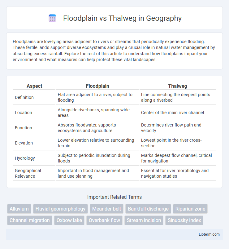
| Aspect | Floodplain | Thalweg |
|---|---|---|
| Definition | Flat area adjacent to a river, subject to flooding | Line connecting the deepest points along a riverbed |
| Location | Alongside riverbanks, spanning wide areas | Center of the main river channel |
| Function | Absorbs floodwater, supports ecosystems and agriculture | Determines river flow path and velocity |
| Elevation | Lower elevation relative to surrounding terrain | Lowest point in the river cross-section |
| Hydrology | Subject to periodic inundation during floods | Marks deepest flow channel, critical for navigation |
| Geographical Relevance | Important in flood management and land use planning | Essential for river morphology and navigation studies |
Introduction: Defining Floodplain and Thalweg
A floodplain is the flat area adjacent to a river or stream that experiences periodic flooding, serving as a natural buffer zone that absorbs excess water during heavy rainfall. The thalweg represents the line of lowest elevation within a river channel, marking the path of the strongest current and deepest flow. Understanding the distinctions between floodplain and thalweg is essential for effective river management, flood risk assessment, and ecological conservation.
Key Differences Between Floodplain and Thalweg
The floodplain is the flat area adjacent to a river, which floods during high water events, serving as a natural overflow zone and sediment deposit area. The thalweg represents the deepest continuous line along the riverbed, marking the path of fastest current and defining the main channel's flow direction. Key differences include their physical characteristics--floodplain being a wide, flat landform prone to flooding, while the thalweg is a narrow, submerged line indicating the river's deepest points and velocity.
Geological Formation of Floodplains
Floodplains are geological formations consisting of flat or gently sloping land adjacent to rivers, created through the deposition of sediment during periodic flooding events. These alluvial deposits build layers of fertile soil over time, shaping the floodplain's topography and influencing its ecological characteristics. Thalwegs represent the deepest channel lines within a river valley, guiding the main flow and sediment transport that contribute to the formation and evolution of floodplains.
Thalweg: The Deepest Channel in Rivers
The thalweg represents the deepest continuous line along a riverbed, marking the fastest-flowing channel where water velocity and erosion are most intense. It plays a crucial role in determining river navigation routes, sediment transport, and habitat distribution within the floodplain, which encompasses the broader, often submerged area adjacent to the river. Understanding the thalweg's dynamic position aids in flood management, river engineering, and boundary delineation between riparian properties.
Hydrological Functions of Floodplains
Floodplains serve critical hydrological functions by storing excess water during floods, reducing downstream flow velocity, and promoting groundwater recharge, whereas the thalweg represents the deepest continuous line along a river channel, primarily influencing flow velocity and sediment transport. Floodplains act as natural buffers that absorb floodwaters, attenuating peak discharge and minimizing flood risks to adjacent areas. The interaction between floodplains and thalwegs supports sediment deposition and nutrient cycling, enhancing aquatic habitats and maintaining river stability.
Importance of Thalwegs in River Dynamics
Thalwegs represent the line of deepest points along a river channel, playing a crucial role in determining flow velocity and sediment transport within the river system. Understanding thalweg positioning helps predict erosion patterns, channel migration, and habitat distribution, which are essential for effective river management and flood control. Unlike floodplains, which are flat areas adjacent to rivers subject to flooding, thalwegs define the core flow path influencing the river's geomorphology and hydrodynamics.
Ecological Significance: Floodplain vs Thalweg
Floodplains provide critical habitats for diverse plant and animal species due to their nutrient-rich soils and frequent flooding, supporting high biodiversity and ecological productivity. Thalwegs, as the deepest channels in rivers, maintain continuous water flow and serve as essential pathways for aquatic organisms during migration and spawning. The dynamic interaction between floodplains and thalwegs enhances ecosystem resilience by regulating sediment transport, nutrient distribution, and habitat connectivity.
Human Impact on Floodplains and Thalwegs
Human activities such as urbanization, agriculture, and infrastructure development significantly alter floodplains, reducing their natural capacity to absorb and mitigate floodwaters, which increases flood risk and ecosystem degradation. Thalwegs, as the deepest channels of rivers, are often modified by dredging and channelization to improve navigation and flood control, disrupting natural sediment transport and aquatic habitats. These interventions on floodplains and thalwegs lead to decreased biodiversity, altered hydrological patterns, and heightened vulnerability of downstream communities to flooding events.
Floodplain and Thalweg in River Management
Floodplains are flat areas adjacent to rivers that absorb excess water during floods, reducing downstream flood risks and supporting biodiversity. The thalweg represents the deepest part of the river channel, crucial for determining flow velocity and guiding river navigation and habitat distribution. Effective river management integrates floodplain preservation with thalweg monitoring to optimize flood control, ecological health, and sediment transport.
Conclusion: Comparing Floodplain and Thalweg
The floodplain represents the broad, flat area adjacent to a river, frequently inundated during high water events, playing a crucial role in natural water storage and ecosystem support. The thalweg denotes the deepest continuous line along the riverbed, guiding the primary flow and influencing sediment transport and channel morphology. Comparing floodplain and thalweg emphasizes their complementary functions: floodplains regulate overflow and habitat diversity, while thalwegs dictate flow pathways and hydraulic dynamics within river systems.
Floodplain Infographic