Polygons are fundamental geometric shapes consisting of straight, connected line segments that form a closed figure. Understanding the properties and classifications of polygons, such as triangles, quadrilaterals, and pentagons, helps in solving complex math problems and applications in fields like computer graphics and architecture. Explore the rest of this article to deepen your knowledge of polygons and their practical uses.
Table of Comparison
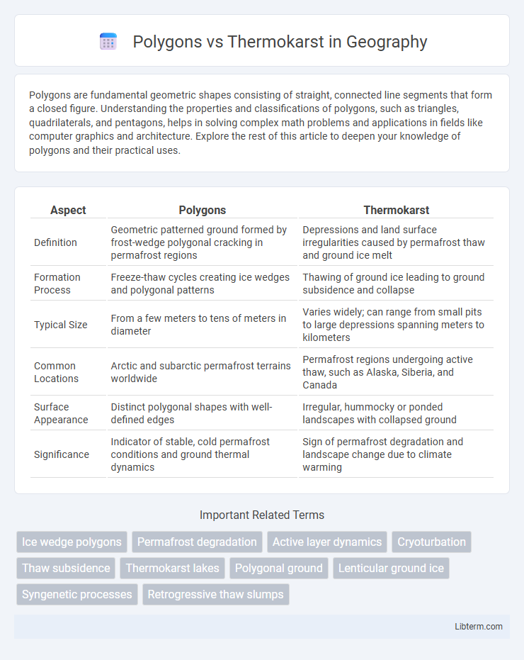
| Aspect | Polygons | Thermokarst |
|---|---|---|
| Definition | Geometric patterned ground formed by frost-wedge polygonal cracking in permafrost regions | Depressions and land surface irregularities caused by permafrost thaw and ground ice melt |
| Formation Process | Freeze-thaw cycles creating ice wedges and polygonal patterns | Thawing of ground ice leading to ground subsidence and collapse |
| Typical Size | From a few meters to tens of meters in diameter | Varies widely; can range from small pits to large depressions spanning meters to kilometers |
| Common Locations | Arctic and subarctic permafrost terrains worldwide | Permafrost regions undergoing active thaw, such as Alaska, Siberia, and Canada |
| Surface Appearance | Distinct polygonal shapes with well-defined edges | Irregular, hummocky or ponded landscapes with collapsed ground |
| Significance | Indicator of stable, cold permafrost conditions and ground thermal dynamics | Sign of permafrost degradation and landscape change due to climate warming |
Introduction to Polygons and Thermokarst
Polygons and thermokarst are key landforms found in permafrost regions, each formed through distinct processes. Polygons originate from the contraction and cracking of frozen ground, creating geometric patterns often visible on Arctic tundra. Thermokarst develops from the thawing of ice-rich permafrost, leading to irregular depressions, subsidence, and dynamic landscape changes.
Defining Polygons in Permafrost Landscapes
Polygons in permafrost landscapes are distinctive, polygonal-shaped ground features formed by the freeze-thaw cycles that create patterned ground. These polygons result from the contraction of ice-rich permafrost during cold periods, producing cracks that fill with ice or sediment, thus shaping the characteristic geometric patterns. Unlike thermokarst, which develops through the melting and subsidence of ice-rich permafrost, polygons represent surface expressions of thermal contraction processes in stable permafrost environments.
Understanding Thermokarst Formation
Thermokarst formation occurs when permafrost thaws unevenly, causing the ground to subside and create irregular landscapes characterized by depressions and mounds. Unlike polygons, which are patterned ground features formed through seasonal freeze-thaw cycles resulting in geometric shapes, thermokarst features develop from the melting of ground ice that destabilizes soil structure. Understanding thermokarst is crucial for assessing permafrost degradation, as its formation leads to significant ecological and geomorphological impacts in Arctic and sub-Arctic regions.
Key Differences Between Polygons and Thermokarst
Polygons are patterned ground features formed by freeze-thaw cycles in permafrost regions, characterized by polygonal cracks and ice wedges, whereas thermokarst results from the thawing of ice-rich permafrost, leading to ground subsidence and irregular surfaces such as pits, troughs, and ponds. Polygons exhibit a stable geometric pattern with raised rims, while thermokarst landscapes display dynamic and often rapidly changing topography due to melting permafrost. The primary distinction lies in polygons being formed by mechanical processes of ice contraction, compared to thermokarst being shaped by thermal melting and ground collapse.
Geomorphological Processes Behind Polygons
Polygons in periglacial environments form through repeated freeze-thaw cycles that create patterned ground by fracturing and sorting soil and ice, a process linked to thermal contraction cracking. These geomorphological processes differ from thermokarst, which results from the melting of ice-rich permafrost causing ground subsidence and irregular surface features. Understanding polygon formation involves analyzing seasonal thermal stresses and ice-wedge growth that structurally define the polygonal network.
Environmental Impacts of Thermokarst Development
Thermokarst development significantly alters permafrost landscapes, causing ground subsidence, disrupted drainage patterns, and increased greenhouse gas emissions from thawed organic matter. Unlike stable polygonal ground formed by seasonal freeze-thaw cycles, thermokarst terrain accelerates soil erosion and releases methane and carbon dioxide, intensifying climate change effects. This environmental transformation threatens Arctic biodiversity and infrastructure by destabilizing ecosystems and undermining land surfaces.
Role of Climate Change in Polygon and Thermokarst Dynamics
Climate change accelerates the formation and evolution of both polygons and thermokarst features by altering temperature and moisture conditions in permafrost regions. Rising temperatures increase ground ice melt, which destabilizes soil structures, enhancing thermokarst development and expanding polygonal patterns due to seasonal freeze-thaw cycles. The intensification of these processes influences carbon release from permafrost, impacting global greenhouse gas emissions and feedback loops.
Ecological Consequences for Arctic and Subarctic Regions
Polygons and thermokarst landscapes in Arctic and Subarctic regions significantly affect permafrost stability, hydrology, and vegetation patterns, directly influencing carbon cycling and greenhouse gas emissions. Polygonal ground, formed by seasonal freeze-thaw cycles, enhances soil moisture distribution, supporting diverse wetland ecosystems, while thermokarst results from thawing permafrost causing ground subsidence, altering drainage networks and promoting the release of stored soil carbon. These contrasting geomorphological features drive habitat heterogeneity, impacting biodiversity and ecosystem resilience amid climate warming.
Remote Sensing Methods for Mapping Polygons and Thermokarst
Remote sensing methods for mapping polygons and thermokarst features utilize high-resolution satellite imagery, LiDAR, and UAV-based photogrammetry to capture detailed surface morphology and vegetation patterns indicative of permafrost dynamics. Multispectral and hyperspectral sensors enable differentiation between ice-rich polygons and thermokarst depressions by analyzing spectral signatures of soil moisture and vegetation stress. Synthetic Aperture Radar (SAR) provides critical data on surface deformation and subsidence, enhancing detection accuracy of evolving thermokarst landscapes over time.
Future Research Directions and Monitoring of Permafrost Features
Future research on polygons and thermokarst should prioritize high-resolution remote sensing techniques combined with ground-based monitoring to capture dynamic permafrost changes under climate warming. Integrating multispectral satellite data with UAV surveys enables precise mapping of spatial and temporal variations in polygonal cracks and thermokarst subsidence. Developing predictive models using machine learning algorithms to analyze these permafrost features will enhance understanding of their feedback effects on greenhouse gas emissions and landscape evolution.
Polygons Infographic