Cartography involves the art and science of mapmaking, merging geographic data with design principles to visually represent spatial information accurately. This discipline enhances navigation, urban planning, and environmental monitoring through detailed, scalable visuals. Explore the rest of the article to discover how your understanding of cartography can transform spatial awareness and decision-making.
Table of Comparison
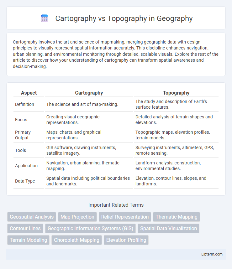
| Aspect | Cartography | Topography |
|---|---|---|
| Definition | The science and art of map-making. | The study and description of Earth's surface features. |
| Focus | Creating visual geographic representations. | Detailed analysis of terrain shapes and elevations. |
| Primary Output | Maps, charts, and graphical representations. | Topographic maps, elevation profiles, terrain models. |
| Tools | GIS software, drawing instruments, satellite imagery. | Surveying instruments, altimeters, GPS, remote sensing. |
| Application | Navigation, urban planning, thematic mapping. | Landform analysis, construction, environmental studies. |
| Data Type | Spatial data including political boundaries and landmarks. | Elevation, contour lines, slopes, and landforms. |
Introduction to Cartography and Topography
Cartography involves the science and art of creating maps that represent spatial information visually, emphasizing accurate symbolization and scale to convey geographic data effectively. Topography focuses on detailing the Earth's surface features, including elevation, terrain shapes, and natural or man-made elements, essential for understanding landscape variations. Both disciplines use geographic information systems (GIS) and surveying techniques, but cartography prioritizes map design while topography emphasizes surface measurement and representation.
Definitions: Cartography vs Topography
Cartography is the scientific study and art of creating maps that represent spatial information, combining geography, design, and data visualization techniques to convey geographic knowledge effectively. Topography specifically refers to the detailed description and representation of the Earth's surface features, including elevation, terrain shapes, and landforms, often depicted through contour lines and elevation models. While cartography covers the broader process of map-making, topography emphasizes the precise measurement and depiction of natural and man-made landscape features.
Historical Development of Cartography and Topography
Cartography has evolved from ancient Babylonian clay tablets to sophisticated digital mapping systems, reflecting humanity's growing need to represent spatial information accurately over time. Topography, as a branch of cartography, developed alongside early surveys and military engineering in ancient Egypt and Rome, emphasizing detailed landform and elevation depiction. The Scientific Revolution and advancements in measurement tools during the 18th and 19th centuries accelerated the precision of both fields, establishing modern standards in geographic representation and terrain analysis.
Key Objectives and Purposes
Cartography focuses on the art and science of creating maps to visually represent geographical information for navigation, planning, and communication. Topography emphasizes the detailed description and analysis of the earth's surface features, including elevation, terrain, and landforms, primarily for land assessment and scientific study. Both disciplines intersect in providing spatial data but differ in purpose, with cartography prioritizing visual representation and topography concentrating on physical geographic characteristics.
Tools and Techniques Used
Cartography involves the use of Geographic Information Systems (GIS), digital mapping software, and satellite imagery to create accurate and scalable maps, emphasizing data visualization and spatial analysis. Topography relies on tools such as theodolites, total stations, GPS devices, and LiDAR technology to measure and represent the Earth's surface elevations and landforms with precision. While cartographic techniques prioritize map design and thematic representation, topographic methods focus on detailed terrain measurement and elevation contouring for accurate geospatial profiling.
Types of Maps and Topographical Representations
Cartography encompasses various map types including political, thematic, and topographic maps, each serving distinct purposes through different data visualization techniques. Topography specifically involves detailed representations of Earth's surface features such as elevation, terrain contours, and landform shapes using contour lines, shading, and digital elevation models (DEMs). Topographical maps are essential for activities requiring precise terrain information including hiking, geological surveys, and urban planning, highlighting physical landscape elements with accuracy and clarity.
Data Collection Methods
Cartography relies on geospatial data collected through satellite imagery, GPS surveys, and aerial photography to create accurate and visually interpretable maps. Topography involves detailed data collection using ground-based methods such as total stations, LiDAR scanning, and topographic surveys to measure land elevations and features precisely. Both disciplines utilize remote sensing and Geographic Information Systems (GIS) but differ in their focus on visualization (cartography) versus terrain analysis (topography).
Applications in Modern Science and Industry
Cartography facilitates the creation of detailed maps used in urban planning, navigation systems, and geographic information systems (GIS), enhancing decision-making in environmental management and transportation logistics. Topography provides precise elevation data crucial for civil engineering projects, land surveying, and natural disaster prediction models, improving infrastructure development and risk assessment. Together, cartography and topography integrate spatial analysis tools essential for resource management, agriculture optimization, and military strategy.
Challenges and Limitations
Cartography faces challenges in accurately representing three-dimensional terrain on two-dimensional maps, leading to distortions in scale and spatial relationships. Topography encounters limitations due to the difficulty of capturing fine details of elevation changes in complex landscapes, especially in densely vegetated or rugged areas. Both disciplines struggle with data accuracy, resolution constraints, and the integration of real-time updates for dynamic environmental changes.
Future Trends in Cartography and Topography
Future trends in cartography emphasize the integration of real-time data through AI-powered geographic information systems (GIS) and augmented reality (AR) for immersive mapping experiences. Advances in topography leverage drone-based LiDAR technology and high-resolution satellite imagery to create precise, dynamic terrain models essential for urban planning and environmental monitoring. The convergence of these technologies enables the development of interactive, 3D maps that enhance decision-making in sectors such as disaster management, infrastructure development, and autonomous navigation.
Cartography Infographic