Volcanism is the process through which magma, gas, and ash erupt from beneath the Earth's surface, shaping landscapes and influencing the global climate. Understanding volcanic activity is crucial for assessing natural hazards and mitigating risks to communities living nearby. Explore the rest of the article to discover how volcanism impacts our planet and what it means for Your safety.
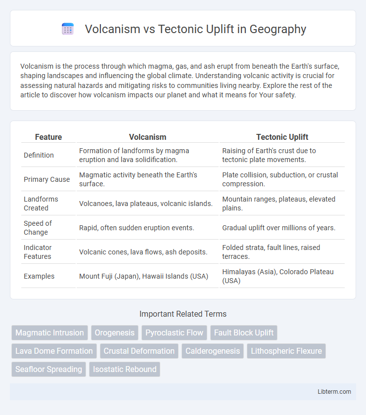
Table of Comparison
| Feature | Volcanism | Tectonic Uplift |
|---|---|---|
| Definition | Formation of landforms by magma eruption and lava solidification. | Raising of Earth's crust due to tectonic plate movements. |
| Primary Cause | Magmatic activity beneath the Earth's surface. | Plate collision, subduction, or crustal compression. |
| Landforms Created | Volcanoes, lava plateaus, volcanic islands. | Mountain ranges, plateaus, elevated plains. |
| Speed of Change | Rapid, often sudden eruption events. | Gradual uplift over millions of years. |
| Indicator Features | Volcanic cones, lava flows, ash deposits. | Folded strata, fault lines, raised terraces. |
| Examples | Mount Fuji (Japan), Hawaii Islands (USA) | Himalayas (Asia), Colorado Plateau (USA) |
Introduction to Volcanism and Tectonic Uplift
Volcanism involves the eruption of magma through the Earth's crust, creating landforms such as volcanoes, lava plateaus, and volcanic islands. Tectonic uplift occurs when Earth's lithospheric plates collide or shift, causing the elevation of rock layers and mountain formation. Both processes significantly shape the Earth's surface by altering topography through distinct geological mechanisms.
Defining Volcanism: Processes and Features
Volcanism refers to the eruption of magma, gases, and volcanic ash through the Earth's crust, forming features such as volcanoes, lava flows, and volcanic cones. Key processes include magma generation in the mantle, magma ascent through fractures, and surface eruption, which create diverse landforms like shield volcanoes, stratovolcanoes, and calderas. Volcanism significantly impacts geological landscapes, contributing to crust formation and alteration, unlike tectonic uplift which involves the vertical elevation of Earth's surface due to plate tectonic forces.
Understanding Tectonic Uplift: Mechanisms and Types
Tectonic uplift occurs due to vertical elevation of the Earth's crust driven by plate interactions, including convergent boundaries where subduction zones force landmasses upward, and continental collisions that create mountain ranges like the Himalayas. Mechanisms such as isostatic rebound result from crustal thickening or erosion, restoring gravitational balance and elevating the terrain. Types of tectonic uplift include regional uplift affecting broad areas and local uplift focused on specific faults or folds, both shaping Earth's landscapes independent of volcanic activity.
Geological Evidence of Volcanic Activity
Geological evidence of volcanic activity includes the presence of volcanic rocks such as basalt, andesite, and rhyolite, which form from cooled lava or pyroclastic materials. Features like volcanic cones, calderas, and lava flows provide direct indicators of past eruptions, while volcanic ash layers found in sedimentary sequences help date and correlate volcanic events. Geochemical signatures, including elevated levels of elements like sulfur and boron in soils and rocks, further distinguish volcanic processes from tectonic uplift phenomena.
Signs and Impact of Tectonic Uplift in Landscapes
Tectonic uplift manifests through elevated landforms such as mountain ranges, fault scarps, and raised plateaus, driven by plate collisions or mantle dynamics. This geological process significantly reshapes landscapes by increasing elevation, creating steep slopes, and influencing river courses, which can lead to enhanced erosion and sediment deposition. Signs of tectonic uplift are evident in terraces, uplifted marine terraces, and altered drainage patterns, reflecting ongoing crustal deformation and landscape evolution.
Volcanism vs Tectonic Uplift: Key Differences
Volcanism involves the eruption of magma from beneath the Earth's crust, creating volcanic landforms such as cones and lava plateaus, whereas tectonic uplift refers to the vertical elevation of Earth's surface due to plate movements, forming mountain ranges and highlands. Volcanic activity results in new rock formation through magma solidification, while tectonic uplift primarily repositions existing rock layers without melting. The timescale of volcanism can be episodic and rapid during eruptions, contrasting with the gradual, long-term process of tectonic uplift driven by plate tectonics.
How Volcanism and Uplift Shape Earth’s Surface
Volcanism shapes Earth's surface by erupting magma, creating new landforms such as volcanoes, lava plains, and islands through the accumulation of solidified lava and volcanic ash. Tectonic uplift raises sections of the crust, forming mountain ranges, plateaus, and elevated terrains by the collision and folding of tectonic plates. These processes work together to continuously reshape landscapes, influencing erosion patterns, drainage systems, and habitat formation.
Case Studies: Notable Volcanic and Uplifted Regions
The East African Rift Valley exemplifies tectonic uplift through crustal stretching and faulting, creating elevated plateaus and rift valleys. In contrast, the Hawaiian Islands highlight volcanism-driven land formation with their shield volcanoes built from successive lava flows. The Andes Mountains combine both processes, showcasing uplift from tectonic plate convergence and volcanic activity along the Pacific Ring of Fire.
Environmental and Human Impacts
Volcanism releases ash, lava, and gases that can devastate ecosystems, disrupt air quality, and cause long-term soil fertility changes, impacting agriculture and human health. Tectonic uplift alters landscapes over time, influencing river patterns, climate, and biodiversity, while triggering earthquakes that can damage infrastructure and displace populations. Both processes shape environmental conditions crucial to human settlement, resource availability, and disaster risk management.
Future Research and Monitoring Methods
Future research on volcanism and tectonic uplift emphasizes the integration of satellite-based InSAR technology and real-time seismic monitoring to detect subtle ground deformations and magma movements. Advanced machine learning algorithms are being developed to analyze multi-source geospatial data, improving eruption forecasting and uplift prediction accuracy. Continuous monitoring of gas emissions combined with deep borehole strain measurements enhances understanding of magma chamber dynamics and tectonic stress accumulation.
Volcanism Infographic