Atlas is a collection of maps or charts that represent geographic areas, providing detailed visual information about locations, landscapes, and spatial relationships. It often includes thematic maps covering topics like climate, population, or economic activity, making it an essential tool for education, research, and navigation. Explore the rest of the article to discover how an atlas can enhance your understanding of the world.
Table of Comparison
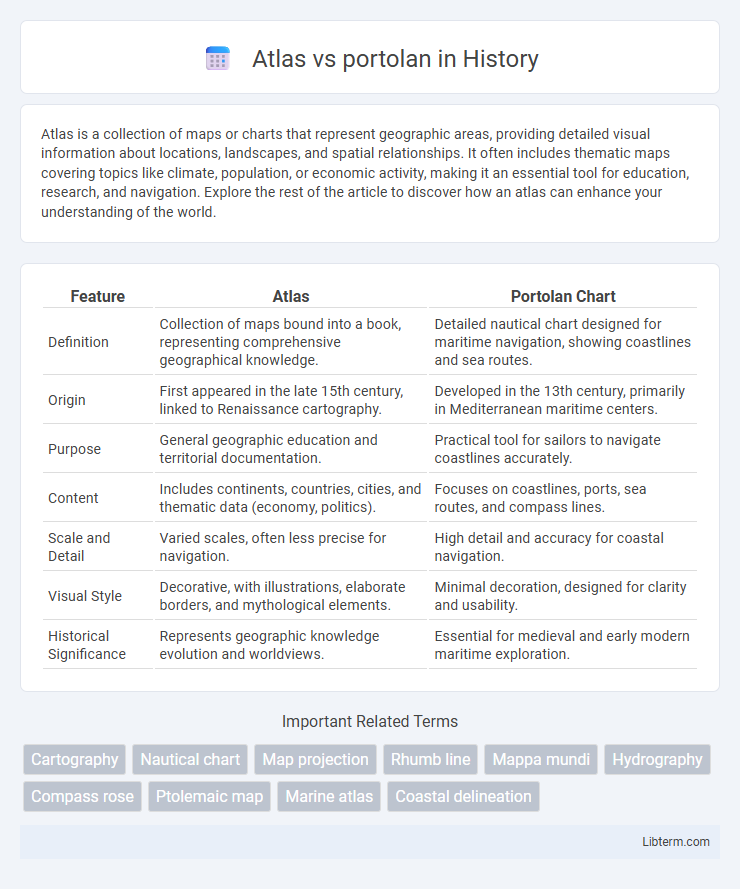
| Feature | Atlas | Portolan Chart |
|---|---|---|
| Definition | Collection of maps bound into a book, representing comprehensive geographical knowledge. | Detailed nautical chart designed for maritime navigation, showing coastlines and sea routes. |
| Origin | First appeared in the late 15th century, linked to Renaissance cartography. | Developed in the 13th century, primarily in Mediterranean maritime centers. |
| Purpose | General geographic education and territorial documentation. | Practical tool for sailors to navigate coastlines accurately. |
| Content | Includes continents, countries, cities, and thematic data (economy, politics). | Focuses on coastlines, ports, sea routes, and compass lines. |
| Scale and Detail | Varied scales, often less precise for navigation. | High detail and accuracy for coastal navigation. |
| Visual Style | Decorative, with illustrations, elaborate borders, and mythological elements. | Minimal decoration, designed for clarity and usability. |
| Historical Significance | Represents geographic knowledge evolution and worldviews. | Essential for medieval and early modern maritime exploration. |
Introduction to Atlases and Portolans
Atlases are comprehensive collections of maps that provide detailed geographic information, often including thematic layers like political boundaries, terrain, and climate data. Portolans are early nautical charts designed primarily for maritime navigation, characterized by their precise coastlines and rhumb lines connecting ports. While atlases offer broad spatial analysis, portolans emphasize practical sea routes and coastal features essential for sailors.
Historical Origins of Atlases
Atlases originated during the 16th century, evolving from earlier manuscript maps and serving as collections of coordinated geographic information, unlike portolan charts, which emerged in the 13th century as detailed, coastal navigation maps used primarily by Mediterranean sailors. The first true atlas, created by Abraham Ortelius in 1570, compiled uniform, printed maps that provided systematic cartographic knowledge beyond the practical, route-centered focus of portolans. While portolan charts emphasized compass directions and shorelines for maritime navigation, atlases expanded to include thematic, political, and physical geography, reflecting a shift to a comprehensive worldview in early modern cartography.
The Emergence of Portolan Charts
Portolan charts emerged in the Mediterranean during the 13th century, revolutionizing maritime navigation with their detailed coastlines and accurate compass roses. Unlike atlases, which compiled multiple maps into bound volumes for diverse geographic representation, portolan charts served as practical tools crafted from sailors' observations to guide seafaring routes. Their precision in depicting harbors, capes, and sea routes marked a significant advancement over earlier cartographic methods and influenced the development of future nautical maps.
Key Differences Between Atlases and Portolans
Atlases are comprehensive collections of maps offering geographic, political, and thematic data across multiple regions, while portolans are specialized nautical charts emphasizing coastal features and navigation routes primarily for maritime use. Atlases utilize standardized projections and often include detailed legends, whereas portolans feature hand-drawn rhumb lines and precise coastal outlines without uniform scale. The purpose of atlases centers on broad geographic knowledge, whereas portolans serve practical navigation, reflecting historical cartographic techniques vital for sailors.
Materials and Production Techniques
Atlas maps were primarily crafted using high-quality vellum or parchment, with meticulous hand-drawn illustrations and colorings applied by skilled scribes and cartographers, ensuring durability and detailed representation. Portolan charts utilized durable parchment as well, but their production emphasized practical navigational use, featuring precise compass roses and rhumb lines drawn with ink, often produced through a combination of hand-drawing and early printing techniques. The contrasting production techniques highlight Atlas maps as more decorative and encyclopedic, while portolan charts prioritized functionality and accuracy for maritime navigation.
Geographic Accuracy and Mapping Styles
Portolans prioritize coastal accuracy with detailed maritime routes and landmarks, featuring a highly practical style for navigation, often using compass roses and rhumb lines. Atlases emphasize comprehensive geographic coverage, combining political boundaries, topographic features, and thematic data in stylized, often decorative maps aimed at broad spatial understanding. Geographic accuracy in portolans excels in coastal detail but lacks inland depth, whereas atlases provide a more balanced representation of both coastal and interior regions.
Notable Examples of Atlases and Portolans
Notable examples of atlases include the "Theatrum Orbis Terrarum" by Abraham Ortelius, widely regarded as the first modern atlas, and the "Atlante Nautico" by Battista Agnese, known for its detailed nautical charts. Among famous portolans, the "Carta Pisana," a 13th-century navigational chart, stands out for its early representation of Mediterranean coastlines, while the Catalan Atlas, created by Abraham Cresques, is renowned for its rich illustrations and comprehensive geographical information. These works exemplify the evolution from practical maritime maps to richly detailed collections of cartographic knowledge.
Uses and Significance in Navigation
Atlases provide comprehensive collections of maps that assist navigators in planning long-distance voyages by offering detailed representations of geographical regions, including political boundaries and topographical features. Portolans, with their precise coastal charts and rhumb lines, played a critical role in medieval and early modern navigation by enabling sailors to plot courses along coastlines and identify key harbors accurately. The significance of portolans lies in their practical use for maritime pilots during active voyages, while atlases serve as broader reference tools for strategic route planning and geographic education.
Influence on Modern Cartography
The Atlas, with its comprehensive and systematically organized maps, established foundational principles in geographic representation that directly influenced modern cartography's emphasis on accuracy and thematic layering. Portolan charts, renowned for their precise coastal outlines and navigational rhumb lines, contributed significantly to the development of maritime navigation techniques still employed in contemporary map-making. Together, these historical tools integrated spatial accuracy and practical navigation, shaping the evolution of modern cartographic standards and digital mapping systems.
Conclusion: Atlas vs Portolan in Mapping History
Atlas and portolan charts each played crucial roles in the evolution of cartography, with atlases providing comprehensive, systematic representations of the world and portolans offering detailed coastal navigation aids critical for maritime exploration. The atlas revolutionized how geographic knowledge was compiled and accessed, supporting scientific study and global awareness, while portolan charts enhanced practical navigation through accurate, hand-drawn compass lines and coastal features. Together, these mapping tools reflect the transition from empirical seafaring techniques to organized geographic scholarship, marking pivotal developments in mapping history.
Atlas Infographic