T-O maps, also known as medieval world maps, depict the known world divided into three continents: Asia, Europe, and Africa, separated by a "T" formed by the Mediterranean Sea and the Nile and Don rivers. These maps symbolize the medieval European worldview, blending geographic knowledge with religious and cultural beliefs. Explore the rest of the article to understand how T-O maps influenced cartography and medieval thought.
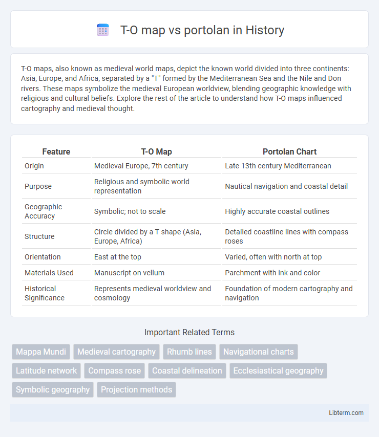
Table of Comparison
| Feature | T-O Map | Portolan Chart |
|---|---|---|
| Origin | Medieval Europe, 7th century | Late 13th century Mediterranean |
| Purpose | Religious and symbolic world representation | Nautical navigation and coastal detail |
| Geographic Accuracy | Symbolic; not to scale | Highly accurate coastal outlines |
| Structure | Circle divided by a T shape (Asia, Europe, Africa) | Detailed coastline lines with compass roses |
| Orientation | East at the top | Varied, often with north at top |
| Materials Used | Manuscript on vellum | Parchment with ink and color |
| Historical Significance | Represents medieval worldview and cosmology | Foundation of modern cartography and navigation |
Introduction to Medieval Cartography
T-O maps, characterized by their simple circular design dividing the world into three parts--Asia, Europe, and Africa--reflect medieval religious and philosophical views rather than geographic accuracy. In contrast, portolan charts emerged in the 13th century as practical nautical maps, featuring detailed coastlines, compass roses, and rhumb lines essential for Mediterranean navigation. These two medieval cartographic styles illustrate the transition from symbolic worldviews to more empirical geographic representations in medieval mapmaking.
What is a T-O Map?
A T-O map, also known as a medieval mappa mundi, is a schematic representation of the known world divided into three continents--Asia, Europe, and Africa--separated by a "T" formed by bodies of water within an "O" symbolizing the ocean. This map type prioritizes theological and symbolic elements over geographic accuracy, reflecting medieval Christian cosmology and emphasizing Jerusalem often placed at the center. In contrast, portolan charts offer precise coastal navigation details based on compass bearings and distances, serving practical seafarers rather than conceptual or religious interpretations.
Understanding Portolan Charts
Portolan charts emerged in the 13th century as highly accurate nautical maps characterized by networked rhumb lines and detailed coastlines, primarily designed to aid Mediterranean maritime navigation. Unlike the symbolic and theological T-O maps that divided the world into three continents (Asia, Europe, Africa) with Jerusalem at the center, portolan charts emphasized practical geography based on direct observations from sailors' experiences. Understanding portolan charts reveals their function as early tools for precise sea travel, reflecting empirical knowledge over the abstract representation found in T-O maps.
Historical Development of T-O Maps
T-O maps originated in the early medieval period, reflecting a Christian worldview dividing the world into three continents: Asia, Europe, and Africa, separated by a "T" shape formed by bodies of water within an encompassing "O" representing the ocean. These maps were conceptual rather than navigational, serving theological and educational purposes in monasteries and religious texts. In contrast, portolan charts emerged in the late 13th century with detailed coastal depictions and compass roses, emphasizing practical navigation based on empirical observations rather than symbolic representation.
Origins and Evolution of Portolan Maps
Portolan maps originated in the Mediterranean during the 13th century as practical navigational charts, marked by their detailed coastlines and rhumb lines radiating from compass roses, unlike the symbolic and religiously oriented T-O maps from the medieval period. Portolans evolved through empirical maritime observations, improving accuracy and facilitating trade and exploration, with their exactness driven by sailors' needs rather than theological representation. The gradual refinement of portolan maps paralleled advances in cartographic techniques and geographic knowledge, ultimately influencing the development of later nautical charts and early modern cartography.
Key Features: T-O Maps vs Portolan Charts
T-O maps feature a simplistic, symbolic representation of the world, dividing it into three continents (Asia, Europe, and Africa) with Jerusalem at the center, emphasizing theological and medieval worldview rather than geographic accuracy. In contrast, portolan charts are highly detailed navigational maps created in the 13th and 14th centuries, featuring intricate coastlines, compass roses, and rhumb lines for maritime navigation across the Mediterranean and beyond. Portolan charts prioritize practical usability for sailors with precise coastal data while T-O maps serve more as conceptual, religiously inspired worldviews.
Geographic Accuracy: Comparison and Analysis
T-O maps, originating in the medieval period, depict a symbolic representation of the world with limited geographic accuracy, dividing the land into three continents separated by a T-shaped body of water within an O-shaped world. Portolan charts, developed during the 13th century for maritime navigation, offer precise geographic details with accurate coastlines, compass roses, and rhumb lines, significantly improving navigational reliability compared to T-O maps. The analysis highlights that while T-O maps served theological and educational purposes, portolan charts provided practical and detailed geographic data essential for early explorers and traders.
Purposes and Uses in Medieval Navigation
T-O maps primarily served as symbolic representations of the known world in medieval Europe, emphasizing religious and cultural divisions rather than navigational accuracy. Portolan charts were practical tools for maritime navigation, featuring detailed coastlines, compass roses, and rhumb lines to guide sailors across the Mediterranean and Atlantic. While T-O maps reinforced medieval worldview and ecclesiastical authority, portolan charts enabled precise route planning and safer sea travel during the Age of Discovery.
Artistic and Cultural Significance
T-O maps, characterized by their symbolic and theological elements, reflect medieval Europe's worldview by dividing the world into three continents centered on Jerusalem, emphasizing spiritual and Christian perspectives in art. Portolan charts, emerging during the Age of Exploration, showcase detailed coastal cartography and practical navigation tools that highlight advancements in maritime knowledge and Mediterranean trade culture. The contrasting artistic styles reveal shifts from medieval religious iconography in T-O maps to precise geographic representation and empirical observation in portolans, marking a significant evolution in cultural approaches to mapping.
Lasting Impact on Modern Cartography
The T-O map, characterized by its symbolic division of the world into three continents, influenced medieval European worldviews and religious perspectives but offered limited geographic accuracy. Portolan charts introduced precise nautical detail and coastal outlines based on compass bearings, revolutionizing navigation and enabling global exploration. The lasting impact of portolan maps on modern cartography is evident in their advancement of practical, accurate maritime mapping techniques that underpin contemporary geographic information systems (GIS).
T-O map Infographic