Convective processes play a critical role in transporting heat and moisture within the atmosphere, influencing weather patterns and climate dynamics globally. Understanding convective motion can improve weather forecasting and mitigate severe weather risks such as thunderstorms and hurricanes. Discover more about how convective forces shape your local climate and impact daily life in the rest of this article.
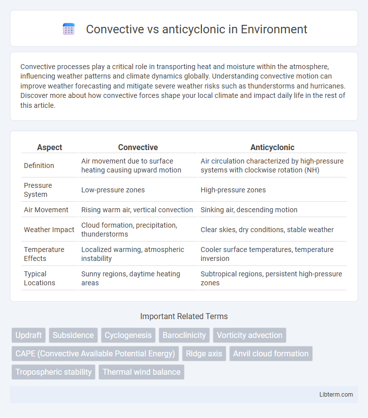
Table of Comparison
| Aspect | Convective | Anticyclonic |
|---|---|---|
| Definition | Air movement due to surface heating causing upward motion | Air circulation characterized by high-pressure systems with clockwise rotation (NH) |
| Pressure System | Low-pressure zones | High-pressure zones |
| Air Movement | Rising warm air, vertical convection | Sinking air, descending motion |
| Weather Impact | Cloud formation, precipitation, thunderstorms | Clear skies, dry conditions, stable weather |
| Temperature Effects | Localized warming, atmospheric instability | Cooler surface temperatures, temperature inversion |
| Typical Locations | Sunny regions, daytime heating areas | Subtropical regions, persistent high-pressure zones |
Introduction to Convective and Anticyclonic Systems
Convective systems form when warm, moist air rises rapidly, leading to cloud formation and intense weather events like thunderstorms. Anticyclonic systems, characterized by high-pressure zones, involve descending air that suppresses cloud formation and typically brings clear, stable weather. Understanding the dynamics of convective and anticyclonic systems is crucial for accurate weather forecasting and climate analysis.
Defining Convective Patterns
Convective patterns are characterized by upward air movements caused by surface heating, leading to cloud formation and precipitation. These patterns often result in cumulative or towering cumulus clouds and localized thunderstorms driven by thermal convection. Understanding convective mechanisms is essential to distinguish them from anticyclonic patterns, which involve subsiding air and clear skies.
Understanding Anticyclonic Circulation
Anticyclonic circulation refers to the clockwise rotation of air around high-pressure systems in the Northern Hemisphere, characterized by descending air that inhibits cloud formation and leads to clear, stable weather conditions. Unlike convective circulation, which involves vertical air movement causing thunderstorms and precipitation, anticyclonic circulation promotes dry, calm atmospheres due to subsiding air that warms adiabatically. Understanding anticyclonic circulation is crucial for weather forecasting as it influences temperature patterns, reduces atmospheric instability, and often leads to prolonged periods of fair weather.
Key Differences Between Convective and Anticyclonic Flows
Convective flows arise from buoyancy-driven motion due to temperature differences, causing warm air to rise and cooler air to sink, while anticyclonic flows are characterized by clockwise rotation in the Northern Hemisphere linked to high-pressure systems. Convective flows primarily impact vertical air movement and turbulence, whereas anticyclonic flows influence horizontal wind patterns and stable atmospheric conditions. The intensity and scale of convective flows are governed by thermal gradients, whereas anticyclonic flows are controlled by pressure gradients and the Coriolis effect.
Atmospheric Conditions Favoring Convection
Convective atmospheric conditions favor the development of warm, moist air rising rapidly due to surface heating and instability, promoting thunderstorms and cumulonimbus cloud formation. Anticyclonic conditions, characterized by high-pressure systems and subsiding dry air, inhibit convection by stabilizing the atmosphere and suppressing vertical air movement. Key factors influencing convection include surface temperature, humidity levels, and atmospheric lapse rates, which differ significantly from the stable, dry environment typical of anticyclones.
Typical Weather Associated with Anticyclonic Systems
Anticyclonic systems typically bring clear skies, stable atmospheric conditions, and low precipitation due to descending air that suppresses cloud formation. These high-pressure areas often result in calm winds, warm temperatures during the day, and cooler nights caused by radiational cooling under clear skies. In contrast to convective systems which generate thunderstorms and heavy rain, anticyclones promote dry and settled weather patterns.
Impacts on Local and Global Weather
Convective systems drive localized intense rainfall, thunderstorms, and severe weather events, significantly influencing regional climate patterns through vertical heat and moisture transport. Anticyclonic systems promote stable, dry conditions by suppressing convection, leading to prolonged clear skies and potential heatwaves on a local scale. Globally, the interplay between convective and anticyclonic patterns shapes large-scale atmospheric circulation, affecting jet streams, monsoon variability, and the distribution of climatic zones.
Meteorological Tools for Distinguishing Flow Types
Meteorological tools such as Doppler radar and satellite imagery are essential for distinguishing convective flow from anticyclonic patterns by analyzing wind velocity, direction, and cloud formation dynamics. Convective flows are identified through vertical motion and updrafts associated with thunderstorm cells, while anticyclonic flows exhibit clockwise rotation in the Northern Hemisphere and clear skies due to high-pressure systems. Advanced numerical weather models integrate these observations to simulate and predict distinct atmospheric circulation behaviors.
Real-World Examples of Convective and Anticyclonic Events
Convective events, such as thunderstorms in the Midwest United States and monsoon-driven storms in India, are characterized by intense upward air movement causing heavy rainfall and lightning. In contrast, anticyclonic events like the Atlantic subtropical high and Siberian High involve descending dry air that leads to clear skies and prolonged dry conditions. These phenomena significantly impact weather patterns, agricultural productivity, and disaster preparedness in their respective regions.
Conclusion: Choosing the Right Model for Forecasting
Selecting the appropriate model for forecasting depends on the specific atmospheric conditions and desired accuracy in predicting convective or anticyclonic events. Convective models excel in capturing rapid, localized storm development and vertical air movement, while anticyclonic models better represent stable, high-pressure systems with large-scale circulation patterns. Accurate weather predictions rely on integrating model strengths tailored to the dynamic features of either convective thunderstorms or anticyclonic high-pressure systems.
Convective Infographic