Aerial photography captures images from elevated positions, often using drones or aircraft, providing unique perspectives for surveying, mapping, and creative projects. This technique enhances your ability to analyze landscapes, monitor construction, or showcase real estate from breathtaking angles. Discover how aerial photography can transform your visual storytelling in the rest of the article.
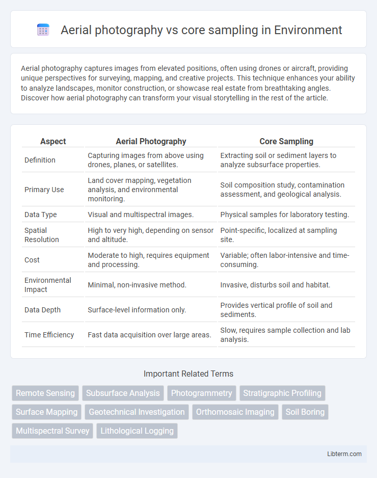
Table of Comparison
| Aspect | Aerial Photography | Core Sampling |
|---|---|---|
| Definition | Capturing images from above using drones, planes, or satellites. | Extracting soil or sediment layers to analyze subsurface properties. |
| Primary Use | Land cover mapping, vegetation analysis, and environmental monitoring. | Soil composition study, contamination assessment, and geological analysis. |
| Data Type | Visual and multispectral images. | Physical samples for laboratory testing. |
| Spatial Resolution | High to very high, depending on sensor and altitude. | Point-specific, localized at sampling site. |
| Cost | Moderate to high, requires equipment and processing. | Variable; often labor-intensive and time-consuming. |
| Environmental Impact | Minimal, non-invasive method. | Invasive, disturbs soil and habitat. |
| Data Depth | Surface-level information only. | Provides vertical profile of soil and sediments. |
| Time Efficiency | Fast data acquisition over large areas. | Slow, requires sample collection and lab analysis. |
Introduction to Aerial Photography and Core Sampling
Aerial photography captures high-resolution images from airborne platforms, enabling large-scale geological and environmental surveys with detailed spatial information. Core sampling involves extracting cylindrical sections of earth or rock to analyze subsurface compositions, providing precise data on stratigraphy and mineral content. Combining aerial photography with core sampling enhances site characterization by integrating visual surface data with physical subsurface evidence.
Fundamental Principles of Aerial Photography
Aerial photography captures detailed surface images using cameras mounted on aircraft or drones, relying on principles like scale, resolution, and perspective to analyze landscape features accurately. Core sampling involves extracting subsurface material for direct geological or environmental analysis, providing precise data on soil or rock composition. Unlike core sampling's physical penetration, aerial photography uses electromagnetic radiation reflection to gather spatial and temporal information efficiently over large areas.
Core Sampling: Methods and Applications
Core sampling involves extracting cylindrical sections of soil, rock, or ice to analyze subsurface conditions, enabling detailed geological, environmental, and engineering assessments. Common methods include rotary drilling, percussion drilling, and sonic drilling, each tailored to specific materials and depth requirements. Core samples provide critical data for mineral exploration, soil contamination studies, groundwater analysis, and construction site evaluations, offering precise insights that aerial photography cannot capture.
Advantages of Aerial Photography in Data Collection
Aerial photography offers rapid, large-scale data collection, capturing extensive geographic areas that are impractical for traditional core sampling. It provides detailed visual information for land use analysis, environmental monitoring, and terrain mapping without physical disturbance to the site. This method significantly reduces time and labor costs while enabling real-time data assessment and more frequent updates compared to the slower, localized nature of core sampling.
Core Sampling: Strengths and Limitations
Core sampling provides direct physical evidence of subsurface conditions, enabling precise analysis of soil composition, stratigraphy, and contaminants. Its strengths lie in offering detailed, quantifiable data essential for geological, environmental, and engineering assessments, although the method is limited by its invasive nature, higher costs, and potential sampling bias due to localized extraction points. Compared to aerial photography, core sampling delivers tangible, verifiable samples but covers a much smaller area, making it less efficient for large-scale surveys.
Comparing Data Accuracy: Aerial Photos vs Core Samples
Aerial photography provides broad spatial coverage with high-resolution imagery useful for surface analysis, yet it may lack subsurface accuracy crucial for geological and environmental assessments. Core sampling delivers precise, direct data from subsurface layers, offering detailed information about soil composition, stratigraphy, and contamination levels often missed by aerial methods. While aerial photos excel in mapping and visual context, core samples provide superior accuracy for quantitative analysis and validation of underground conditions.
Cost and Time Efficiency Analysis
Aerial photography offers a cost-effective and time-efficient method for large-scale environmental and geological surveys, covering extensive areas quickly with minimal labor. Core sampling, while providing precise subsurface data, is more expensive and time-consuming due to the need for specialized equipment and onsite extraction. Evaluating project requirements and budget constraints helps determine whether aerial imaging's rapid data acquisition or core sampling's detailed analysis best suits the study objectives.
Practical Applications in Geology and Environmental Science
Aerial photography offers extensive spatial data ideal for mapping landforms and assessing large-scale geological features, enhancing environmental monitoring and hazard identification. Core sampling provides precise subsurface data essential for understanding soil composition, stratigraphy, and groundwater conditions crucial in mineral exploration and contamination studies. Combining aerial imagery with core sample analysis enables comprehensive geological assessments and more informed environmental management decisions.
Technological Advancements Supporting Each Method
Aerial photography leverages high-resolution drones and satellite imagery equipped with multispectral sensors to capture detailed surface patterns and environmental changes rapidly. Core sampling utilizes precision drilling technologies and advanced geochemical analysis tools to extract and analyze subsurface materials, providing accurate data on soil composition and stratigraphy. Both methods integrate GPS and GIS technologies for precise spatial mapping, enhancing data accuracy and interpretation in environmental and geological studies.
Choosing the Right Approach: Key Considerations
Choosing the right approach between aerial photography and core sampling depends on project goals and site conditions. Aerial photography offers rapid, large-scale surface imaging ideal for mapping and monitoring vegetation or topography, while core sampling provides precise subsurface data essential for geological analysis and contamination assessment. Evaluating factors such as desired detail, budget, and environmental impact ensures optimal selection between these complementary techniques.
Aerial photography Infographic