GIS mapping leverages geographic information system technology to visualize, analyze, and interpret spatial data for diverse applications such as urban planning, environmental monitoring, and resource management. Accurate GIS mapping enhances decision-making by providing detailed insights into land use, population distribution, and infrastructure development. Explore the rest of the article to discover how your projects can benefit from advanced GIS mapping techniques.
Table of Comparison
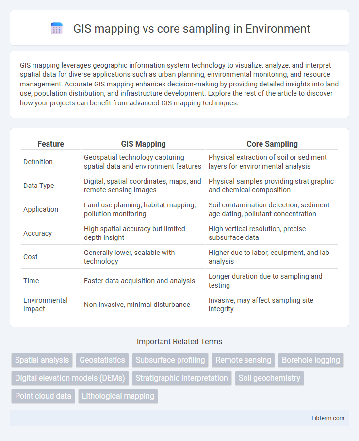
| Feature | GIS Mapping | Core Sampling |
|---|---|---|
| Definition | Geospatial technology capturing spatial data and environment features | Physical extraction of soil or sediment layers for environmental analysis |
| Data Type | Digital, spatial coordinates, maps, and remote sensing images | Physical samples providing stratigraphic and chemical composition |
| Application | Land use planning, habitat mapping, pollution monitoring | Soil contamination detection, sediment age dating, pollutant concentration |
| Accuracy | High spatial accuracy but limited depth insight | High vertical resolution, precise subsurface data |
| Cost | Generally lower, scalable with technology | Higher due to labor, equipment, and lab analysis |
| Time | Faster data acquisition and analysis | Longer duration due to sampling and testing |
| Environmental Impact | Non-invasive, minimal disturbance | Invasive, may affect sampling site integrity |
Introduction to GIS Mapping and Core Sampling
GIS mapping utilizes geographic information systems to collect, analyze, and visualize spatial data, enabling precise mapping of terrain, infrastructure, and environmental features. Core sampling involves extracting vertical columns of soil or rock to study subsurface composition, providing direct, physical data about geological layers and properties. Combining GIS mapping with core sampling enhances site analysis by integrating surface spatial data with detailed subsurface profiles, improving decision-making in geology, environmental science, and construction.
Overview of Geospatial Data Collection
GIS mapping utilizes satellite imagery, aerial photography, and LiDAR to capture spatial data across large areas rapidly, enabling detailed visualization and analysis of geographic features. Core sampling provides precise subsurface information by extracting cylindrical sediment or soil samples, essential for understanding soil composition, stratigraphy, and contamination levels. Both methods complement each other by integrating surface and subsurface data for comprehensive geospatial analysis in environmental studies, urban planning, and resource management.
How GIS Mapping Works
GIS mapping operates by collecting, storing, and analyzing spatial data using geographic information systems to create detailed, layered maps that reveal patterns and relationships across various terrains. It integrates data from satellite imagery, aerial photography, and ground surveys to visualize geographic features and environmental conditions in real time. These dynamic maps facilitate decision-making in fields such as urban planning, agriculture, and environmental management by providing precise spatial context that core sampling alone cannot offer.
Core Sampling: Methods and Applications
Core sampling involves extracting cylindrical sections of soil, rock, or sediment to analyze subsurface properties and composition, making it essential for geological, environmental, and engineering studies. Methods include rotary drilling, hand augering, and percussion coring, each selected based on depth, material hardness, and study objectives. Core sampling provides direct physical evidence of subsurface conditions, enabling accurate assessments for mineral exploration, groundwater studies, and contamination analysis, which complements but differs fundamentally from the spatial data visualization of GIS mapping.
Key Differences Between GIS Mapping and Core Sampling
GIS mapping uses geographic information systems to create spatial data visualizations, enabling large-scale analysis of terrain and environmental features. Core sampling involves extracting physical soil or rock samples from specific locations for detailed subsurface examination, providing precise geotechnical or environmental data. Unlike GIS mapping's non-invasive, digital approach, core sampling requires physical interaction with the site to obtain granular geological information.
Advantages of GIS Mapping in Geological Studies
GIS mapping offers precise spatial analysis by integrating various geological data layers, enhancing the visualization of complex subsurface features. It enables efficient data management and real-time updates, which reduce the need for extensive physical sampling like core sampling. This approach significantly lowers costs and environmental impact while improving decision-making accuracy in geological studies.
Benefits of Core Sampling for Accurate Results
Core sampling offers precise subsurface data by physically extracting soil, rock, or sediment layers, enabling detailed analysis of material composition and stratigraphy. This method provides accurate information about geological conditions, contamination levels, and mineral content that GIS mapping alone cannot capture due to its reliance on surface data and remote sensing. Combining core sampling with GIS enhances decision-making in construction, environmental assessment, and resource exploration by incorporating verified, high-resolution ground truth data.
Limitations of GIS Mapping and Core Sampling
GIS mapping limitations include spatial data inaccuracies, resolution constraints, and reliance on existing data sources, which may lead to incomplete or outdated representations of the terrain. Core sampling faces challenges such as high costs, time consumption, limited sampling points, and potential sampling bias due to inaccessible or heterogeneous subsurface conditions. Both methods require careful interpretation to mitigate errors, emphasizing the need for integrated approaches to achieve comprehensive geological and environmental analyses.
Integrating GIS Mapping with Core Sampling Techniques
Integrating GIS mapping with core sampling techniques enhances spatial data accuracy by combining precise subsurface information with geospatial visualization, enabling detailed analysis of geological formations. This integration supports advanced decision-making in environmental studies, agriculture, and urban planning by providing layered, location-specific insights from core samples overlayed on interactive GIS maps. Utilizing GIS technology to interpret core sampling data improves resource management and risk assessment through more accurate mapping of soil composition, contaminants, and mineral deposits.
Choosing the Right Method for Your Project
Selecting between GIS mapping and core sampling depends on project goals and site conditions; GIS mapping excels in spatial data visualization and large-area analysis, providing detailed geospatial context. Core sampling offers precise subsurface information and material composition through physical extraction, essential for soil, sediment, or construction assessments. Combining both methods enhances accuracy by integrating surface mapping with in-depth geological data, optimizing decision-making for environmental, engineering, or excavation projects.
GIS mapping Infographic