Remote sensing utilizes satellite or aerial sensor technologies to detect and monitor physical characteristics of an area by measuring its reflected and emitted radiation. This technology plays a crucial role in environmental monitoring, urban planning, and disaster management by providing timely and accurate data. Explore the rest of the article to understand how remote sensing can benefit your projects and decision-making processes.
Table of Comparison
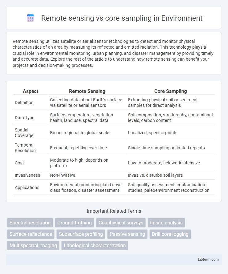
| Aspect | Remote Sensing | Core Sampling |
|---|---|---|
| Definition | Collecting data about Earth's surface via satellite or aerial sensors | Extracting physical soil or sediment samples for direct analysis |
| Data Type | Surface temperature, vegetation health, land use, spectral data | Soil composition, stratigraphy, contaminant levels, carbon content |
| Spatial Coverage | Broad, regional to global scale | Localized, specific points |
| Temporal Resolution | Frequent, repetitive over time | Single-time sampling or limited repeats |
| Cost | Moderate to high, depends on platform | Low to moderate, fieldwork intensive |
| Invasiveness | Non-invasive | Invasive, disturbs soil layers |
| Applications | Environmental monitoring, land cover classification, disaster assessment | Soil quality assessment, contamination studies, paleoenvironment reconstruction |
Introduction to Remote Sensing and Core Sampling
Remote sensing involves acquiring data about Earth's surface using satellite or aerial sensors, capturing electromagnetic radiation to analyze land cover, vegetation, and geological features without physical contact. Core sampling extracts cylindrical sections of soil, sediment, or rock for direct examination, providing detailed stratigraphic and compositional data critical for geological and environmental analysis. Both methods complement each other by combining large-scale spatial information from remote sensing with precise subsurface characterization from core sampling.
Fundamental Principles of Remote Sensing
Remote sensing operates on the fundamental principle of detecting and measuring electromagnetic radiation reflected or emitted from Earth's surface, allowing for non-invasive data collection across large areas. Core sampling, by contrast, involves physically extracting subsurface material to directly analyze soil, sediment, or rock properties, providing precise, localized information. Remote sensing techniques utilize satellite or airborne sensors to capture spectral signatures that help identify vegetation, minerals, and land use, optimizing spatial and temporal coverage unattainable by core sampling methods.
Core Sampling: Methods and Applications
Core sampling involves extracting cylindrical sections of soil, rock, or ice to analyze subsurface properties, providing direct and precise data on material composition, structure, and stratigraphy. This method is widely used in geology, environmental studies, and archaeology to assess sediment layers, contamination levels, or paleoclimate conditions. Core samples offer detailed temporal and spatial resolution, essential for accurate site characterization, resource exploration, and monitoring environmental changes.
Key Differences Between Remote Sensing and Core Sampling
Remote sensing uses satellite or aerial imagery to collect data about Earth's surface without physical contact, enabling broad spatial coverage and real-time monitoring. Core sampling involves extracting physical soil, ice, or sediment samples for detailed, localized analysis of composition, structure, and history. Remote sensing offers non-invasive, large-scale observations, whereas core sampling provides precise, ground-truth data critical for accurate scientific assessments.
Advantages of Remote Sensing Techniques
Remote sensing techniques offer non-invasive data collection over large and inaccessible areas, enabling efficient environmental monitoring and resource management. These methods provide high-resolution spatial and spectral information that enhances the detection of changes in land use, vegetation health, and geological features without disturbing the site. Remote sensing reduces time and labor costs compared to core sampling, allowing continuous and real-time data acquisition across diverse terrains.
Limitations of Remote Sensing Approaches
Remote sensing has limitations such as reduced accuracy in detecting subsurface features and challenges in penetrating dense vegetation or soil layers, which core sampling can directly address by providing physical soil or material profiles. Remote sensing data may suffer from atmospheric interference, resolution constraints, and interpretation complexities that affect precise analysis. These factors make core sampling essential for validating and supplementing remote sensing observations in geological and environmental studies.
Benefits of Core Sampling in Geological Studies
Core sampling provides direct access to subsurface materials, enabling precise analysis of rock layers, mineral content, and geological structures. This method allows accurate determination of stratigraphy, porosity, and fluid content essential for resource exploration and environmental assessments. Unlike remote sensing, core sampling delivers tangible evidence critical for calibrating geophysical data and validating geological models.
Challenges Faced in Core Sampling
Core sampling encounters significant challenges such as difficulty in extracting undisturbed samples from heterogeneous or consolidated layers, which can compromise data accuracy. It often struggles with limited spatial coverage and high operational costs in inaccessible or hazardous environments, hindering comprehensive site analysis. In contrast, remote sensing provides extensive area monitoring but lacks the direct subsurface detail core sampling delivers, underscoring the need to address core sampling limitations for precise geological and environmental assessments.
Integration of Remote Sensing and Core Sampling Data
Integration of remote sensing and core sampling data enhances geological and environmental analysis by combining spatially extensive surface information with detailed subsurface profiles. Remote sensing provides high-resolution imagery and spectral data that identify surface features and anomalies, while core sampling offers precise stratigraphic, geochemical, and mineralogical data from specific depths. This synergistic approach improves accuracy in resource estimation, environmental monitoring, and land-use planning by correlating surface patterns with underground characteristics.
Future Trends in Subsurface Exploration Technologies
Remote sensing and core sampling are evolving with advancements in machine learning, hyperspectral imaging, and nanosensor technologies, driving more accurate subsurface data acquisition. Integration of drone-based remote sensing platforms and AI-enhanced core sampling analysis accelerates real-time decision-making in geological surveys. Future trends prioritize non-invasive, high-resolution methods that minimize environmental impact while maximizing data precision for resource exploration and environmental monitoring.
Remote sensing Infographic