Remote sensing collects data about Earth's surface through satellite or aerial sensor technologies, enabling precise monitoring of environmental changes and land use. It supports applications in agriculture, forestry, urban planning, and disaster management by providing timely, accurate information for decision-making. Explore the rest of this article to discover how remote sensing can enhance your understanding of spatial dynamics.
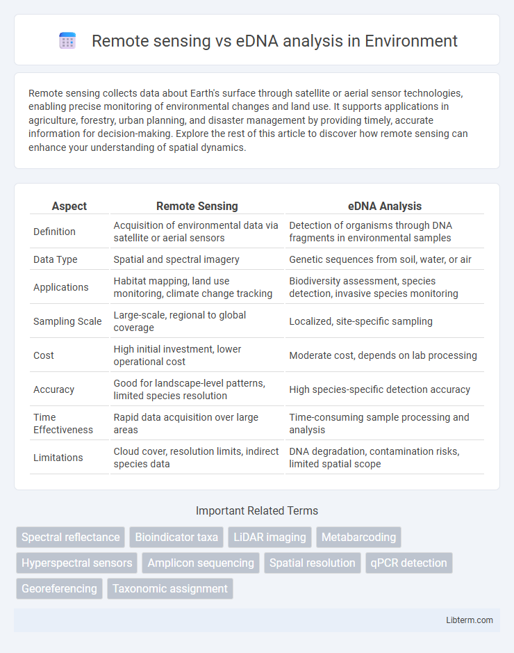
Table of Comparison
| Aspect | Remote Sensing | eDNA Analysis |
|---|---|---|
| Definition | Acquisition of environmental data via satellite or aerial sensors | Detection of organisms through DNA fragments in environmental samples |
| Data Type | Spatial and spectral imagery | Genetic sequences from soil, water, or air |
| Applications | Habitat mapping, land use monitoring, climate change tracking | Biodiversity assessment, species detection, invasive species monitoring |
| Sampling Scale | Large-scale, regional to global coverage | Localized, site-specific sampling |
| Cost | High initial investment, lower operational cost | Moderate cost, depends on lab processing |
| Accuracy | Good for landscape-level patterns, limited species resolution | High species-specific detection accuracy |
| Time Effectiveness | Rapid data acquisition over large areas | Time-consuming sample processing and analysis |
| Limitations | Cloud cover, resolution limits, indirect species data | DNA degradation, contamination risks, limited spatial scope |
Introduction to Remote Sensing and eDNA Analysis
Remote sensing utilizes satellite or aerial sensor technologies to detect and monitor physical characteristics of an area, providing large-scale environmental data with high spatial resolution. Environmental DNA (eDNA) analysis detects genetic material from organisms in water, soil, or air samples, offering precise biodiversity assessments without direct observation. Combining remote sensing with eDNA enhances ecosystem monitoring by integrating broad spatial coverage with detailed species-specific information.
Defining Remote Sensing in Environmental Monitoring
Remote sensing in environmental monitoring involves acquiring data about Earth's surface without direct contact, using satellite imagery, aerial photography, or drones equipped with sensors. This technology captures spatial and temporal information on land cover, vegetation health, water quality, and habitat changes, enabling large-scale and continuous observation. Compared to eDNA analysis, which detects genetic material from organisms to assess biodiversity, remote sensing offers broader ecosystem-level monitoring and rapid data collection over extensive areas.
What is eDNA Analysis?
eDNA analysis involves collecting and examining genetic material shed by organisms into their environment, such as water or soil, to detect species presence without direct observation. This technique offers precise, non-invasive monitoring of biodiversity and species distribution, particularly in aquatic ecosystems. Compared to remote sensing, which captures large-scale environmental data using satellites or drones, eDNA provides species-specific information critical for conservation and ecological studies.
Technological Principles: Remote Sensing vs eDNA
Remote sensing utilizes satellite or aerial sensor technologies to detect and monitor physical characteristics of areas by measuring reflected or emitted electromagnetic radiation. Environmental DNA (eDNA) analysis relies on extracting and amplifying genetic material shed by organisms into their surroundings, enabling species detection without direct observation. While remote sensing provides spatially extensive data on habitats and ecosystems, eDNA offers highly specific biological information at the molecular level for biodiversity assessment and monitoring.
Applications in Biodiversity Assessment
Remote sensing provides large-scale, spatially continuous data for monitoring habitats and ecosystem changes, enabling rapid assessment of vegetation health, land cover, and species distribution patterns. eDNA analysis offers precise detection of species presence and biodiversity at a molecular level by sampling environmental DNA from soil, water, or air, allowing identification of rare, elusive, or invasive species. Combining remote sensing with eDNA enhances biodiversity assessment by integrating landscape-scale environmental data with species-specific genetic information, improving conservation planning and ecosystem management.
Spatial and Temporal Coverage Comparison
Remote sensing enables large-scale spatial coverage by capturing continuous data across vast geographic areas, providing real-time or frequent temporal updates through satellite or aerial sensors. eDNA analysis offers fine-scale temporal resolution by detecting species presence from environmental samples, but its spatial coverage is limited to specific collection sites and requires repeated sampling for temporal trends. Integrating remote sensing with eDNA enhances biodiversity monitoring by combining broad spatial data with precise, species-specific temporal information.
Data Accuracy and Resolution Differences
Remote sensing provides high spatial resolution data capturing broad environmental patterns, yet its accuracy may be limited by atmospheric interference and sensor calibration. eDNA analysis offers precise species-level identification with high taxonomic resolution but depends on sample quality and can be influenced by DNA degradation in the environment. Combining remote sensing with eDNA enhances ecosystem monitoring by balancing large-scale spatial coverage and fine-scale biological accuracy.
Cost Efficiency and Resource Requirements
Remote sensing offers cost-efficient large-scale data acquisition with minimal labor, leveraging satellite or drone imagery for extensive environmental monitoring. eDNA analysis requires specialized laboratory equipment and trained personnel, increasing resource demands despite providing precise species-level detection. Combining both methods optimizes cost efficiency by balancing broad spatial coverage from remote sensing with detailed biodiversity insights from eDNA.
Limitations and Challenges of Each Method
Remote sensing faces limitations in spatial resolution and difficulty detecting below-surface or small-scale ecological changes, hindering precise biodiversity assessments. eDNA analysis struggles with contamination risks, DNA degradation in various environments, and challenges in distinguishing closely related species or quantifying organism abundance. Both methods require complementary tools and careful interpretation to overcome inherent technical and ecological constraints.
Integrating Remote Sensing and eDNA for Enhanced Insights
Integrating remote sensing and eDNA analysis offers powerful tools for biodiversity monitoring by combining large-scale environmental data with precise genetic identification of species presence. Remote sensing provides spatially continuous data on habitat characteristics and environmental changes, while eDNA techniques detect species-specific DNA from environmental samples, enabling detection of cryptic or rare organisms. This synergy enhances ecosystem assessments, improves habitat management, and supports conservation efforts with robust, multi-dimensional insights.
Remote sensing Infographic