Global climate influences ecosystems, weather patterns, and human activities worldwide, shaping agriculture, health, and economies. Understanding its changes is crucial for developing sustainable strategies to mitigate negative impacts. Discover how global climate trends affect your daily life and the planet in the rest of this article.
Table of Comparison
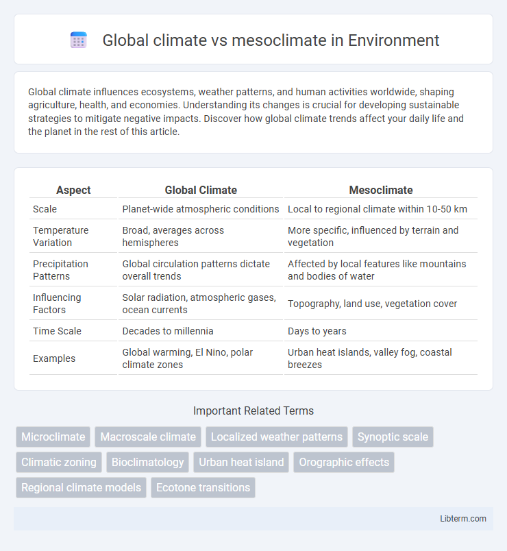
| Aspect | Global Climate | Mesoclimate |
|---|---|---|
| Scale | Planet-wide atmospheric conditions | Local to regional climate within 10-50 km |
| Temperature Variation | Broad, averages across hemispheres | More specific, influenced by terrain and vegetation |
| Precipitation Patterns | Global circulation patterns dictate overall trends | Affected by local features like mountains and bodies of water |
| Influencing Factors | Solar radiation, atmospheric gases, ocean currents | Topography, land use, vegetation cover |
| Time Scale | Decades to millennia | Days to years |
| Examples | Global warming, El Nino, polar climate zones | Urban heat islands, valley fog, coastal breezes |
Introduction to Global Climate and Mesoclimate
Global climate refers to the long-term average weather patterns and atmospheric conditions spanning the entire Earth or large regions, influenced by factors such as latitude, altitude, ocean currents, and solar radiation. Mesoclimate, on the other hand, denotes localized climate conditions within a specific area or landscape unit, shaped by topography, vegetation, and localized airflows over periods ranging from days to decades. Understanding both concepts is crucial for studying weather variability, ecological responses, and human impacts on climate at different spatial scales.
Defining Global Climate: Scope and Patterns
Global climate encompasses the long-term atmospheric conditions and typical weather patterns observed across the entire Earth, influenced by factors such as latitude, ocean currents, and solar radiation distribution. It defines broad climatic zones including tropical, arid, temperate, polar, and Mediterranean regions, reflecting large-scale trends over decades to millennia. Understanding global climate involves analyzing temperature averages, precipitation patterns, and seasonal variations on a planetary scale, which serve as a baseline for studying more localized phenomena like mesoclimate.
Understanding Mesoclimate: Localized Climate Zones
Mesoclimate refers to localized climate zones that exist between the broader global climate patterns and the microclimate of very small areas, such as gardens or individual buildings. Understanding mesoclimate involves studying specific geographic features like valleys, hills, and urban structures that influence temperature, humidity, and wind patterns within a limited region ranging from a few kilometers to tens of kilometers. This localized climate variation affects agriculture, urban planning, and ecosystem management by providing more precise data than global climate models.
Key Differences Between Global Climate and Mesoclimate
Global climate encompasses broad, long-term atmospheric patterns and temperature trends affecting entire continents or large regions over decades or centuries. Mesoclimate refers to localized climate conditions specific to smaller areas such as valleys, urban neighborhoods, or mountains, often influenced by topography and vegetation. Key differences include scale, duration, and factors influencing temperature and precipitation patterns, with global climate driven by large-scale atmospheric circulation and mesoclimate shaped by local geographical features.
Factors Influencing Global Climate
Global climate is influenced by factors such as solar radiation, atmospheric composition, ocean currents, and latitude, dictating temperature and weather patterns worldwide. Mesoclimate, on the other hand, refers to localized climatic conditions shaped by topography, land use, and vegetation within a specific region. Understanding the distinctions between global climate drivers and mesoclimate modifiers is essential for predicting environmental changes at different scales.
Drivers of Mesoclimate Variability
Mesoclimate variability is primarily driven by local factors such as topography, land use, vegetation cover, and water bodies, which influence temperature, humidity, and wind patterns within localized areas. Unlike global climate that depends on large-scale atmospheric circulation, solar radiation, and ocean currents, mesoclimate is shaped by micro-environmental conditions including elevation changes, urban heat islands, and soil moisture variability. These drivers create distinct climate zones on a scale of a few kilometers, significantly affecting local weather phenomena and ecological dynamics.
Examples of Global Climate Phenomena
Global climate phenomena include El Nino-Southern Oscillation (ENSO), which causes significant temperature and precipitation variations across the Pacific Ocean, affecting weather worldwide. The Arctic Oscillation influences atmospheric pressure patterns in the Northern Hemisphere, impacting temperature and storm tracks over Europe and North America. These large-scale climatic events contrast with mesoclimate, which describes localized climate conditions, such as urban heat islands or microclimates within mountainous regions.
Real-World Illustrations of Mesoclimate
Mesoclimate describes localized climate conditions influenced by factors such as topography, vegetation, and urban development, contrasting with the broader patterns captured by the global climate. For instance, vineyards on the slopes of Napa Valley in California benefit from a mesoclimate where the temperature is moderated by nearby mountains and the Pacific Ocean, creating optimal conditions for grape cultivation. Urban heat islands like New York City exhibit distinct mesoclimates with higher temperatures than surrounding rural areas due to concrete surfaces and reduced vegetation.
Interactions Between Global Climate and Mesoclimate
Global climate patterns influence mesoclimate conditions by regulating regional temperature, humidity, and precipitation trends through large-scale atmospheric circulation systems such as the jet stream and trade winds. Mesoclimates, shaped by local topography and land use, in turn modulate global climate feedback loops by affecting surface albedo, evapotranspiration rates, and carbon sequestration within ecosystems. These bidirectional interactions are critical for accurate climate modeling and understanding localized impacts of global climate change on agriculture, biodiversity, and urban planning.
Implications for Environmental Planning and Management
Global climate represents long-term atmospheric patterns affecting large regions and influences broad environmental policies, whereas mesoclimate pertains to localized climate conditions within smaller areas, crucial for site-specific planning. Understanding mesoclimate variations allows urban planners and environmental managers to optimize land use, enhance biodiversity conservation, and mitigate microclimate-related risks such as heat islands or frost pockets. Integrating global climate models with mesoclimate data improves resilience strategies, sustainable resource management, and disaster preparedness in environmental planning.
Global climate Infographic