Camera trap networks provide a non-invasive method for monitoring wildlife populations and behaviors across vast and remote areas. These networks collect high-resolution, time-stamped images that enable researchers to analyze species diversity, movement patterns, and habitat use with minimal disturbance. Explore the rest of the article to discover how your involvement in camera trap initiatives can enhance conservation efforts and ecological research.
Table of Comparison
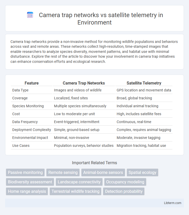
| Feature | Camera Trap Networks | Satellite Telemetry |
|---|---|---|
| Data Type | Images and videos of wildlife | GPS location and movement data |
| Coverage | Localized, fixed sites | Broad, global tracking |
| Species Monitoring | Multiple species simultaneously | Individual animal tracking |
| Cost | Low to moderate per unit | High, includes satellite fees |
| Data Frequency | Event-triggered, intermittent | Continuous, real-time |
| Deployment Complexity | Simple, ground-based setup | Complex, requires animal tagging |
| Environmental Impact | Minimal, non-invasive | Moderate, invasive tagging |
| Use Cases | Population surveys, behavior studies | Migration tracking, habitat use |
Introduction: Comparing Wildlife Monitoring Technologies
Camera trap networks provide high-resolution, localized data by capturing images and videos of wildlife in their natural habitats, enabling species identification and behavior analysis. Satellite telemetry offers broad-scale tracking of animal movements through GPS collars and transmitters, delivering real-time location and migration pattern insights over vast geographic areas. Combining these technologies enhances wildlife monitoring by integrating detailed visual evidence with extensive spatial movement data.
Overview of Camera Trap Networks
Camera trap networks offer extensive, non-invasive wildlife monitoring by automatically capturing images triggered by motion or heat, enabling researchers to collect detailed species occurrence and behavior data across large areas. These networks provide high spatial and temporal resolution, making them ideal for studying elusive or nocturnal animals in diverse habitats. Unlike satellite telemetry, camera traps do not require animal capture, reducing stress and risk while generating vast datasets that enhance biodiversity assessments and conservation planning.
Satellite Telemetry: Principles and Applications
Satellite telemetry utilizes GPS and remote sensing technologies to track animal movement and behavior across vast and inaccessible areas with high temporal resolution. This method collects spatial data in real-time, enabling detailed migration studies, habitat use analysis, and environmental monitoring. Its applications span wildlife conservation, ecological research, and management of endangered species, providing critical insights unattainable by camera trap networks.
Data Collection Methods: Passive vs. Active Monitoring
Camera trap networks utilize passive monitoring by automatically capturing images or videos when triggered by animal movement, enabling continuous and non-invasive data collection over extended periods. Satellite telemetry employs active monitoring through real-time tracking devices attached to animals, providing precise location data and behavior insights but requiring animal capture and device maintenance. The contrast between passive and active methods significantly impacts data resolution, coverage area, and animal disturbance levels in wildlife research.
Spatial Coverage and Scalability
Camera trap networks provide highly detailed, ground-level data across localized habitats but require extensive physical deployment, limiting their spatial coverage and scalability. Satellite telemetry offers expansive spatial coverage and scalable monitoring capabilities over vast and remote areas through GPS tracking, enabling continuous data collection on wide-ranging species movements. Integrating both methods can optimize wildlife monitoring by balancing fine-scale behavioral insights with broad-scale spatial data.
Data Accuracy and Resolution
Camera trap networks deliver high-resolution, species-specific data with precise behavioral and presence information at localized scales, enhancing ecological accuracy. Satellite telemetry provides extensive spatial coverage and real-time movement tracking but often with coarser resolution and potential positional errors due to signal interference. Integrating both methods can optimize wildlife monitoring by balancing fine-scale accuracy and broad-scale movement patterns.
Species Suitability and Target Wildlife
Camera trap networks excel in monitoring terrestrial and cryptic species such as medium to large mammals, ground-dwelling birds, and elusive carnivores, capturing high-resolution images that aid species identification and behavioral studies. Satellite telemetry suits wide-ranging, migratory, or aerial species like large mammals, marine animals, and birds of prey by providing real-time movement data over large spatial scales. Combining these methods enhances biodiversity assessments, with camera traps targeting localized, secretive wildlife and telemetry tracking long-distance movements and habitat use.
Cost, Maintenance, and Logistical Considerations
Camera trap networks generally involve lower upfront costs compared to satellite telemetry, with expenses primarily centered on purchasing multiple cameras and memory storage. Maintenance of camera traps requires regular field visits to replace batteries and retrieve data, making them labor-intensive, whereas satellite telemetry demands significant investment in high-tech GPS collars and subscription services but offers remote data collection with minimal physical upkeep. Logistically, camera traps are limited by terrain accessibility and data retrieval intervals, while satellite telemetry provides real-time tracking capabilities, though it requires expertise for device deployment and data analysis.
Integration and Complementary Uses
Camera trap networks provide high-resolution, localized data on animal behavior and presence, while satellite telemetry offers extensive spatial tracking across large landscapes. Integrating these technologies enhances wildlife monitoring by combining fine-scale behavioral insights with broad movement patterns, improving conservation strategies. Complementary usage allows researchers to validate data, fill gaps, and obtain a comprehensive understanding of species ecology and habitat use.
Future Trends in Wildlife Remote Sensing
Camera trap networks are increasingly integrated with AI-driven analytics, enhancing real-time species identification and behavior monitoring, while satellite telemetry advances with higher-resolution sensors and extended battery life, enabling precise long-term animal movement tracking. Emerging trends emphasize hybrid systems combining camera traps and satellite data to improve habitat modeling and biodiversity assessments across larger landscapes. Innovations in edge computing and data fusion technologies are poised to revolutionize scalable wildlife remote sensing by delivering more accurate, timely ecological insights for conservation efforts.
Camera trap networks Infographic