An inversion layer occurs when a warmer air mass traps cooler air near the ground, preventing vertical mixing and often leading to poor air quality or fog. This atmospheric phenomenon can significantly impact weather patterns and pollution dispersion in urban environments. Explore the rest of the article to understand how inversion layers affect your local climate and health.
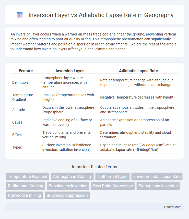
Table of Comparison
| Feature | Inversion Layer | Adiabatic Lapse Rate |
|---|---|---|
| Definition | Atmospheric layer where temperature increases with altitude | Rate of temperature change with altitude due to pressure changes without heat exchange |
| Temperature Gradient | Positive (temperature rises with height) | Negative (temperature decreases with height) |
| Altitude | Occurs in the lower atmosphere (troposphere) | Occurs at various altitudes in the troposphere and stratosphere |
| Cause | Radiative cooling of surface or warm air overlay | Adiabatic expansion or compression of air parcels |
| Effect | Traps pollutants and prevents vertical mixing | Determines atmospheric stability and cloud formation |
| Types | Surface inversion, subsidence inversion, radiation inversion | Dry adiabatic lapse rate (~9.8degC/km), moist adiabatic lapse rate (~5-6degC/km) |
Understanding Atmospheric Layers
The inversion layer occurs when temperature increases with altitude, creating a stable atmospheric layer that traps pollutants and limits vertical air movement. In contrast, the adiabatic lapse rate describes the rate of temperature decrease with height in rising or descending air parcels, influencing cloud formation and weather patterns. Understanding these atmospheric layers is essential for predicting temperature variations, air quality, and atmospheric stability.
What is an Inversion Layer?
An inversion layer is a distinct atmospheric phenomenon where temperature increases with altitude, contrary to the normal decrease observed in the adiabatic lapse rate. This layer traps pollutants and cool air near the surface, leading to poor air quality and potential smog formation. Understanding the inversion layer is crucial for meteorology and environmental science, as it directly impacts weather patterns and air pollution dispersion.
Explaining the Adiabatic Lapse Rate
The adiabatic lapse rate refers to the rate at which atmospheric temperature decreases with an increase in altitude due to adiabatic processes, typically averaging about 9.8degC per kilometer for dry air. It represents temperature changes in a parcel of air that expands and cools or compresses and warms without exchanging heat with the surrounding environment. This rate contrasts with the temperature inversion layer, where temperature increases with height, often leading to stable atmospheric conditions and trapping pollutants near the surface.
Differences Between Inversion Layer and Adiabatic Lapse Rate
The inversion layer is a meteorological phenomenon where temperature increases with altitude, creating a stable atmosphere and trapping pollutants near the surface. In contrast, the adiabatic lapse rate describes the rate at which air temperature decreases with altitude during vertical air movement, either dry or moist, reflecting atmospheric temperature changes without heat exchange. The key difference lies in the inversion layer's temperature increase versus the adiabatic lapse rate's temperature decrease with height under standard atmospheric processes.
Causes of Temperature Inversions
Temperature inversions occur when a layer of warm air sits above cooler air near the surface, preventing normal vertical air mixing. Inversion layers form primarily due to radiational cooling of the ground at night, subsidence of air in high-pressure systems, or cold air drainage into valleys. These contrasts with the adiabatic lapse rate, which describes the normal temperature decrease with altitude due to air parcel expansion and cooling without heat exchange.
Effects of Adiabatic Lapse Rate in the Atmosphere
The adiabatic lapse rate affects atmospheric temperature by dictating how air temperature decreases with altitude due to pressure changes without heat exchange, typically around 9.8degC/km for dry air. This rate influences cloud formation, weather stability, and vertical air movement by determining whether rising air parcels cool faster or slower than the surrounding environment. In contrast to inversion layers, which trap pollutants and create temperature increases with height, the adiabatic lapse rate promotes atmospheric mixing and convection under unstable conditions.
Meteorological Impacts of Inversion Layers
Inversion layers create a stable atmospheric condition by trapping pollutants and moisture near the surface, significantly reducing vertical air mixing and leading to poor air quality. These layers interrupt the normal adiabatic lapse rate, where temperature typically decreases with altitude, instead causing temperature to increase with height and suppress convection. The presence of an inversion layer intensifies fog formation, hinders atmospheric dispersion, and alters local weather patterns by stabilizing the lower atmosphere.
Role of Lapse Rate in Weather Patterns
The adiabatic lapse rate governs the temperature change of rising or sinking air parcels, influencing cloud formation and atmospheric stability crucial for weather development. An inversion layer occurs when the temperature increases with height, reversing the typical lapse rate pattern and trapping pollutants while stabilizing the atmosphere. This stable inversion layer suppresses vertical mixing, preventing convection that usually drives precipitation and storm activity, significantly altering local weather patterns.
Practical Examples and Case Studies
Inversion layers commonly occur in urban areas like Los Angeles, where pollutants trapped by temperature inversions exacerbate smog levels, contrasting with the adiabatic lapse rate's role in stabilizing or destabilizing atmospheric conditions impacting weather. Case studies in mountain valleys show inversion layers can trap cold air and pollutants beneath warmer air aloft, causing frost pockets and poor air quality, whereas the dry and moist adiabatic lapse rates help meteorologists predict cloud formation and storm potential. Practical examples include temperature inversions during winter mornings that inhibit vertical mixing, while understanding the adiabatic lapse rate is crucial in aviation for anticipating turbulence and thermal currents.
Conclusion: Importance in Climate and Weather Prediction
Understanding the differences between the inversion layer and the adiabatic lapse rate is crucial for accurate climate and weather prediction because inversion layers trap pollutants and affect temperature distribution near the surface. The adiabatic lapse rate governs atmospheric stability and vertical temperature changes, influencing cloud formation and storm development. Accurately modeling these phenomena improves forecasts of air quality, temperature variations, and severe weather events.
Inversion Layer Infographic