Cartography is the science and art of creating maps that accurately represent spatial information, combining geography, design, and data visualization. Modern cartography utilizes advanced technologies like GIS (Geographic Information Systems) and remote sensing to enhance precision and usability. Discover how cartography shapes your understanding of the world by exploring the rest of this article.
Table of Comparison
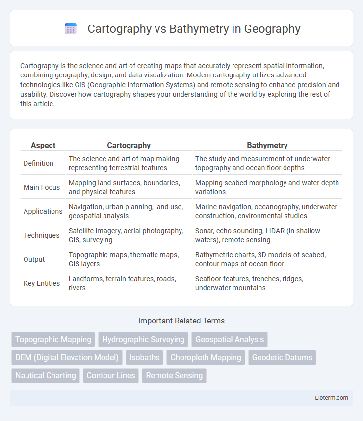
| Aspect | Cartography | Bathymetry |
|---|---|---|
| Definition | The science and art of map-making representing terrestrial features | The study and measurement of underwater topography and ocean floor depths |
| Main Focus | Mapping land surfaces, boundaries, and physical features | Mapping seabed morphology and water depth variations |
| Applications | Navigation, urban planning, land use, geospatial analysis | Marine navigation, oceanography, underwater construction, environmental studies |
| Techniques | Satellite imagery, aerial photography, GIS, surveying | Sonar, echo sounding, LIDAR (in shallow waters), remote sensing |
| Output | Topographic maps, thematic maps, GIS layers | Bathymetric charts, 3D models of seabed, contour maps of ocean floor |
| Key Entities | Landforms, terrain features, roads, rivers | Seafloor features, trenches, ridges, underwater mountains |
Introduction to Cartography and Bathymetry
Cartography involves the art and science of creating maps that visually represent geographic information, emphasizing spatial relationships and geographic features on land. Bathymetry, a specialized branch within cartography, focuses on mapping underwater topography, measuring depths and the shapes of underwater terrain to provide accurate representations of ocean floors, lakes, and rivers. Techniques such as sonar, satellite altimetry, and echo sounding are essential tools in bathymetric data collection, enhancing the precision of underwater maps.
Definition and Scope of Cartography
Cartography is the science and art of creating maps that visually represent geographical areas, incorporating physical, political, and cultural information to aid navigation and spatial understanding. Bathymetry, a subset of cartography, specifically involves mapping underwater topography by measuring ocean floor depths and contours. The scope of cartography extends beyond mere map-making to include data collection, analysis, interpretation, and the use of technology such as GIS for producing accurate, detailed representations of both terrestrial and marine environments.
What is Bathymetry?
Bathymetry is the precise measurement and mapping of underwater topography, detailing the depths and shapes of ocean floors, lakes, and riverbeds. Unlike general cartography that maps terrestrial features, bathymetry uses sonar, satellite altimetry, and echo-sounding technologies to generate detailed maps of underwater terrain. This data is essential for navigation, marine research, and environmental monitoring.
Historical Development of Cartography and Bathymetry
Cartography and bathymetry have evolved through distinct historical trajectories, with cartography tracing back to ancient civilizations like Mesopotamia and Egypt, which developed early map-making techniques for land navigation and territorial management. Bathymetry emerged more prominently during the Age of Discovery when explorers required detailed underwater topography to ensure safe sea passage, leading to advancements in depth measurement tools such as lead lines and echo sounding. The integration of satellite technology and sonar mapping in the 20th century revolutionized both fields, enabling highly accurate representation of terrestrial and underwater landscapes critical for navigation, scientific research, and environmental monitoring.
Key Differences Between Cartography and Bathymetry
Cartography involves the creation and study of maps representing land features, political boundaries, and geographic information, while bathymetry specifically maps underwater topography, detailing ocean floor depths and underwater terrain. Key differences include cartography's broader scope encompassing land-based and thematic mapping versus bathymetry's specialized focus on measuring and analyzing water body depths using sonar and other remote sensing technologies. Cartographic products are used for navigation, urban planning, and geographic analysis, whereas bathymetric data is crucial for marine navigation, underwater construction, and oceanographic research.
Tools and Techniques Used in Cartography
Cartography employs advanced tools like Geographic Information Systems (GIS), remote sensing, and satellite imagery to create accurate maps of terrestrial features. Techniques include spatial data analysis, digital elevation modeling, and photogrammetry to represent landscapes and human-made structures. Unlike bathymetry, which uses sonar and echo sounding for underwater mapping, cartography focuses on topographic and thematic mapping through diverse geospatial technologies.
Methods and Technologies in Bathymetric Mapping
Bathymetric mapping employs sonar technology, such as multibeam and single-beam echo sounders, to measure underwater terrain with high precision, contrasting traditional cartographic methods that rely on satellite imagery and aerial surveys for land mapping. Advanced technologies like LIDAR bathymetry integrate laser pulses to chart shallow coastal waters, enhancing data accuracy and resolution. Modern bathymetric techniques also utilize Autonomous Underwater Vehicles (AUVs) and Remote Operated Vehicles (ROVs) equipped with sophisticated sensors, enabling detailed seafloor mapping in challenging environments.
Applications of Cartography in Modern Society
Cartography plays a crucial role in modern society by providing detailed maps for urban planning, navigation, and environmental management. Unlike bathymetry, which specializes in mapping underwater topography for maritime navigation and oceanographic research, cartography encompasses diverse applications including disaster response, infrastructure development, and location-based services. Advanced GIS technologies enhance cartographic outputs, enabling precise spatial data visualization and decision-making across various industries.
Real-World Uses of Bathymetry
Bathymetry provides detailed underwater topography essential for safe navigation, enabling accurate charting of seabeds to prevent vessel groundings and support maritime traffic management. It supports environmental monitoring by mapping habitats and assessing changes in marine ecosystems crucial for conservation efforts and sustainable fisheries management. Bathymetric data also underpins offshore engineering projects, guiding the construction of underwater pipelines, cables, and wind farms by revealing seabed stability and morphology.
Future Trends in Cartography and Bathymetry
Future trends in cartography and bathymetry emphasize the integration of high-resolution satellite imagery, LiDAR technology, and autonomous underwater vehicles (AUVs) to enhance spatial data accuracy and depth mapping. The adoption of machine learning algorithms for data processing enables real-time updates and predictive modeling in both topographic and underwater terrain analysis. Advances in cloud-based platforms and augmented reality applications are transforming the visualization and accessibility of geospatial and bathymetric datasets for diverse industries.
Cartography Infographic