Cartography is the art and science of creating maps that accurately represent geographical information and spatial relationships to aid navigation, planning, and analysis. Modern cartography integrates geographic information systems (GIS), remote sensing, and digital technologies to produce dynamic, interactive maps tailored to various professional and personal needs. Explore the rest of the article to discover how cartography influences your understanding of the world and enhances decision-making processes.
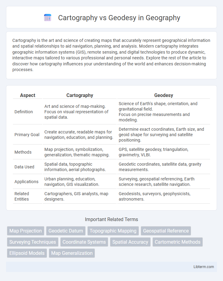
Table of Comparison
| Aspect | Cartography | Geodesy |
|---|---|---|
| Definition | Art and science of map-making. Focus on visual representation of spatial data. |
Science of Earth's shape, orientation, and gravitational field. Focus on precise measurements and modeling. |
| Primary Goal | Create accurate, readable maps for navigation, education, and planning. | Determine exact coordinates, Earth size, and geoid shape for surveying and satellite positioning. |
| Methods | Map projection, symbolization, generalization, thematic mapping. | GPS, satellite geodesy, triangulation, gravimetry, VLBI. |
| Data Used | Spatial data, topographic information, aerial photographs. | Geodetic coordinates, satellite data, gravity measurements. |
| Applications | Urban planning, education, navigation, GIS visualization. | Surveying, geospatial referencing, Earth science research, satellite navigation. |
| Related Entities | Cartographers, GIS analysts, map designers. | Geodesists, surveyors, geophysicists, astronomers. |
Introduction to Cartography and Geodesy
Cartography focuses on the art and science of creating maps, emphasizing the representation of spatial information through symbols, scales, and projections to aid navigation and geographic understanding. Geodesy involves measuring and understanding Earth's geometric shape, orientation in space, and gravity field, forming the foundational data for accurate mapping and positioning. Both disciplines collaborate closely to ensure precise geographic data acquisition and effective spatial visualization.
Defining Cartography: Art and Science of Mapmaking
Cartography combines artistic skills and scientific techniques to create maps that visually represent spatial information accurately. It involves data collection, geographic analysis, and design principles to produce functional and informative maps used for navigation, planning, and education. Unlike geodesy, which focuses on measuring Earth's shape and gravitational field, cartography emphasizes the interpretation and visualization of geographic data.
Geodesy Explained: Understanding Earth's Shape and Size
Geodesy is the scientific discipline focused on measuring and understanding Earth's geometric shape, orientation in space, and gravitational field. It uses precise satellite data, GPS technology, and ground surveys to model the planet's size, shape, and variations in gravitational force. Unlike cartography, which involves map-making and visual representation, geodesy provides the foundational measurements essential for accurate mapping, navigation, and Earth sciences.
Historical Evolution of Cartography and Geodesy
The historical evolution of cartography dates back to ancient civilizations such as Mesopotamia and Egypt, where early maps were created for navigation and territorial claims, advancing through the Renaissance with innovations like Gerardus Mercator's projection. Geodesy originated from the need to understand Earth's size and shape, progressing from Eratosthenes' ancient calculations of Earth's circumference to the use of satellite technology and GPS in modern times. Both fields have evolved through scientific discoveries and technological breakthroughs, shaping accurate geographic representations and spatial measurements fundamental to navigation, mapping, and Earth sciences.
Key Tools and Technologies in Cartography
Cartography relies on Geographic Information Systems (GIS), remote sensing, and digital mapping software like ArcGIS and QGIS to create accurate and dynamic maps. Key tools include Global Positioning System (GPS) devices for precise location data and LiDAR technology for detailed terrain modeling. These technologies facilitate the visualization, analysis, and interpretation of spatial information essential for effective mapmaking.
Essential Instruments and Methods in Geodesy
Geodesy employs highly precise instruments such as GNSS (Global Navigation Satellite Systems), gravimeters, and total stations to measure and monitor Earth's shape, gravity field, and spatial orientation. Techniques including satellite geodesy, triangulation, and leveling enable accurate determination of geodetic control networks, essential for mapping and Earth science applications. These instruments and methods differentiate geodesy's focus on quantifying Earth's geometric and gravitational properties from cartography's emphasis on map design and visualization.
Applications of Cartography in Modern Society
Cartography plays a crucial role in urban planning, navigation systems, and disaster management by providing visually interpretable maps that support decision-making and spatial analysis. In modern society, cartographic techniques enhance geographic information systems (GIS) used in environmental monitoring, infrastructure development, and location-based services. Unlike geodesy, which focuses on measuring Earth's shape and gravitational field, cartography translates spatial data into practical tools for public and commercial use.
Geodesy’s Role in Global Positioning Systems
Geodesy plays a crucial role in Global Positioning Systems (GPS) by providing precise measurements of the Earth's shape, gravitational field, and rotational dynamics, which are essential for accurate satellite positioning and navigation. It establishes the reference coordinate systems and geodetic datums that underpin GPS, ensuring reliable location data across diverse terrains and applications. Unlike cartography, which focuses on map creation and visualization, geodesy supports the foundational scientific framework that enables the functionality and accuracy of GPS technology worldwide.
Comparing Skills and Knowledge Required
Cartography requires strong skills in graphic design, spatial analysis, and geographic information systems (GIS) to create accurate and visually appealing maps. Geodesy demands expertise in mathematics, physics, and satellite technology to measure and understand Earth's geometric shape, gravitational field, and spatial orientation. Both fields necessitate proficiency in data interpretation and geographic principles, but cartography emphasizes visual communication while geodesy focuses on precise measurement and modeling of the Earth.
Future Trends in Cartography and Geodesy
Future trends in cartography emphasize the integration of augmented reality (AR) and real-time data visualization to enhance user interaction and spatial understanding. Geodesy is advancing with the adoption of satellite-based positioning systems, such as GNSS, and the use of quantum sensors for precise Earth measurements. Both fields increasingly leverage artificial intelligence and machine learning for improved data accuracy and predictive modeling in spatial analysis.
Cartography Infographic