Geomorphology studies the formation and evolution of Earth's landforms, analyzing processes like erosion, sedimentation, and tectonic activity that shape landscapes over time. Understanding these dynamic changes provides insights into natural hazards, environmental management, and geological history. Explore the rest of the article to discover how geomorphology impacts your environment and daily life.
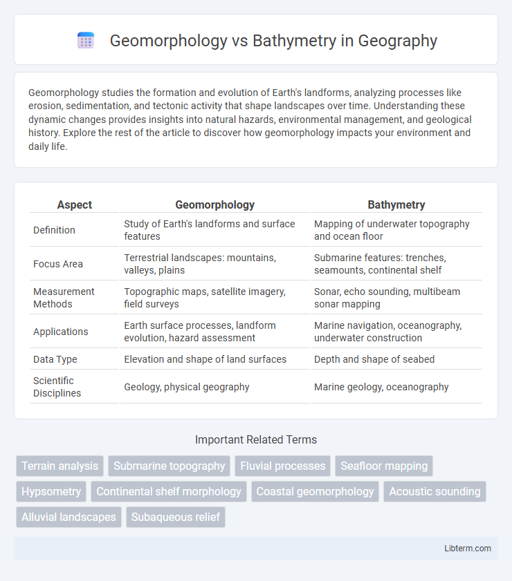
Table of Comparison
| Aspect | Geomorphology | Bathymetry |
|---|---|---|
| Definition | Study of Earth's landforms and surface features | Mapping of underwater topography and ocean floor |
| Focus Area | Terrestrial landscapes: mountains, valleys, plains | Submarine features: trenches, seamounts, continental shelf |
| Measurement Methods | Topographic maps, satellite imagery, field surveys | Sonar, echo sounding, multibeam sonar mapping |
| Applications | Earth surface processes, landform evolution, hazard assessment | Marine navigation, oceanography, underwater construction |
| Data Type | Elevation and shape of land surfaces | Depth and shape of seabed |
| Scientific Disciplines | Geology, physical geography | Marine geology, oceanography |
Introduction to Geomorphology and Bathymetry
Geomorphology studies the Earth's surface features and landforms, analyzing processes that shape terrain over time, including erosion, tectonics, and sedimentation. Bathymetry maps underwater topography, measuring ocean and lake floor depths to reveal seafloor structures like trenches, ridges, and plains. Both disciplines use advanced remote sensing and geospatial technology to understand terrestrial and underwater landscapes, supporting environmental management and geological research.
Defining Geomorphology
Geomorphology studies the formation, evolution, and structure of Earth's landforms, analyzing processes such as erosion, sedimentation, and tectonics to understand surface features. It examines terrestrial landscapes including mountains, valleys, and river systems, providing insights into geological history and environmental change. Unlike bathymetry, which maps underwater topography, geomorphology encompasses both surface and subsurface landform dynamics on continents and coastal zones.
Defining Bathymetry
Bathymetry is the measurement and study of underwater depths and the topography of ocean floors, lakes, and rivers, providing detailed maps of submerged terrain. Unlike geomorphology, which encompasses the broader study of landforms and surface processes on the Earth's crust, bathymetry specifically analyzes seafloor features such as trenches, ridges, and continental shelves. Bathymetric data is crucial for navigation, marine habitat mapping, and understanding geological processes beneath water bodies.
Key Differences Between Geomorphology and Bathymetry
Geomorphology studies the formation and evolution of landforms on the Earth's surface, analyzing processes like erosion, sedimentation, and tectonics, while bathymetry specifically maps and measures underwater topography, including ocean floors and lake beds. Geomorphology encompasses both terrestrial and underwater landforms, whereas bathymetry is solely concerned with underwater terrain and depth variations. The tools used in geomorphology range from field surveys to remote sensing, but bathymetry relies heavily on sonar, echo sounding, and satellite altimetry for precise depth measurements.
Methods of Data Collection in Geomorphology
Geomorphology employs methods such as remote sensing, aerial photography, field surveys, and LiDAR scanning to collect detailed topographic and landform data. Techniques like GPS mapping and digital elevation models (DEMs) facilitate the analysis of surface features and processes shaping landscapes. In contrast, bathymetry primarily uses sonar, echo sounding, and underwater LiDAR to map seafloor topography and underwater landforms.
Techniques Used in Bathymetric Mapping
Bathymetric mapping relies on advanced techniques such as multibeam echo sounding (MBES) and side-scan sonar, which emit sound pulses to measure water depth and seafloor topography with high precision. Satellite altimetry complements these methods by detecting minute sea surface height variations that infer underwater features over vast oceanic areas. Data from these techniques are processed through geographic information systems (GIS) and digital elevation models (DEMs) to create detailed bathymetric maps critical for navigation, marine research, and resource management.
Applications of Geomorphology in Earth Sciences
Geomorphology provides critical insights into landscape evolution, natural hazard assessment, and soil conservation by analyzing landform structures and processes on Earth's surface. It supports disaster risk management through the identification of floodplains, landslide-prone zones, and erosion patterns, enhancing predictive models for mitigating environmental hazards. Applications extend to guiding sustainable land use planning, groundwater exploration, and understanding tectonic activity impacts on terrain development.
Bathymetry’s Role in Marine and Oceanographic Studies
Bathymetry plays a crucial role in marine and oceanographic studies by providing detailed maps of seafloor topography, essential for understanding underwater geological formations, habitats, and ocean circulation patterns. High-resolution bathymetric data enables scientists to model tsunami risks, track sediment transport, and identify potential sites for marine biodiversity conservation. Unlike geomorphology, which broadly studies landforms, bathymetry focuses specifically on underwater terrain, making it indispensable for navigation, resource exploration, and environmental monitoring in marine environments.
Interconnections Between Geomorphology and Bathymetry
Geomorphology examines the formation and evolution of landforms, while bathymetry maps underwater topography, both providing crucial insights into Earth's surface features. The interconnections between geomorphology and bathymetry are evident in coastal and submarine environments where landform processes influence underwater terrain and vice versa. Detailed bathymetric data enhances geomorphological studies by revealing subsurface structures, sediment transport patterns, and tectonic activity that shape both terrestrial and marine landscapes.
Future Trends in Geomorphological and Bathymetric Research
Advancements in remote sensing technologies, such as LiDAR and multibeam echosounders, are driving future trends in geomorphological and bathymetric research by providing higher resolution and more accurate topographic and seafloor data. Integration of machine learning algorithms enhances the analysis of complex geomorphic features and underwater landscapes, enabling predictive modeling for environmental and climate change studies. Collaborative global initiatives leveraging big data platforms are accelerating the mapping and monitoring of terrestrial and marine terrain dynamics, supporting sustainable resource management and hazard mitigation.
Geomorphology Infographic