Geographical Information Systems analyze spatial data to reveal patterns and relationships critical for decision-making in urban planning, environmental management, and logistics. These systems integrate hardware, software, and data to create detailed maps and models that support efficient resource allocation and risk assessment. Explore the full article to discover how GIS technology can enhance your understanding and use of geographic data.
Table of Comparison
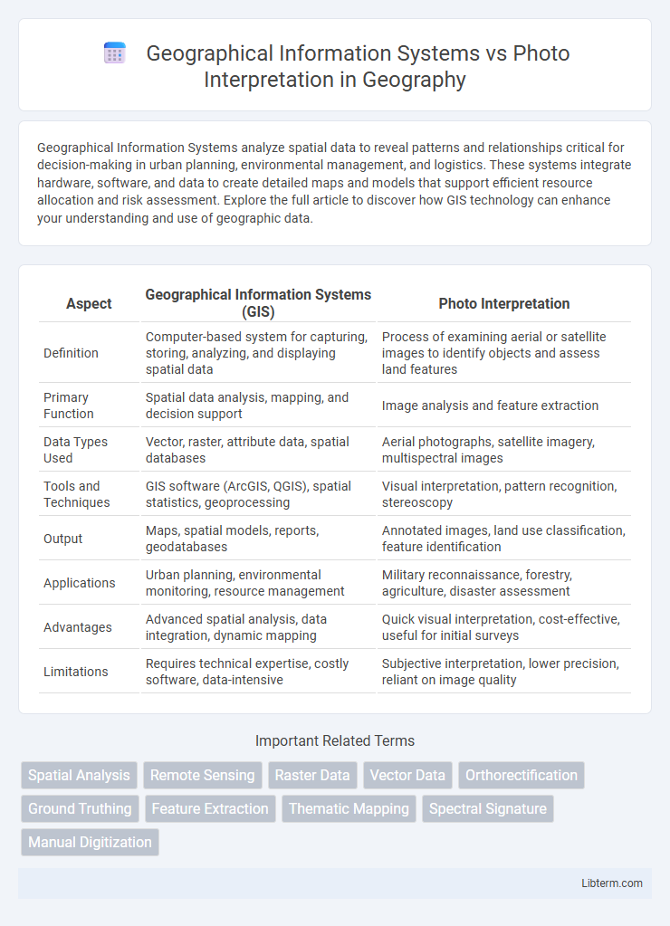
| Aspect | Geographical Information Systems (GIS) | Photo Interpretation |
|---|---|---|
| Definition | Computer-based system for capturing, storing, analyzing, and displaying spatial data | Process of examining aerial or satellite images to identify objects and assess land features |
| Primary Function | Spatial data analysis, mapping, and decision support | Image analysis and feature extraction |
| Data Types Used | Vector, raster, attribute data, spatial databases | Aerial photographs, satellite imagery, multispectral images |
| Tools and Techniques | GIS software (ArcGIS, QGIS), spatial statistics, geoprocessing | Visual interpretation, pattern recognition, stereoscopy |
| Output | Maps, spatial models, reports, geodatabases | Annotated images, land use classification, feature identification |
| Applications | Urban planning, environmental monitoring, resource management | Military reconnaissance, forestry, agriculture, disaster assessment |
| Advantages | Advanced spatial analysis, data integration, dynamic mapping | Quick visual interpretation, cost-effective, useful for initial surveys |
| Limitations | Requires technical expertise, costly software, data-intensive | Subjective interpretation, lower precision, reliant on image quality |
Introduction to Geographical Information Systems (GIS)
Geographical Information Systems (GIS) enable the capture, storage, analysis, and visualization of spatial data to support decision-making across various fields such as urban planning, environmental management, and transportation. Unlike photo interpretation, which primarily involves qualitative analysis of aerial and satellite imagery, GIS integrates multiple data types including maps, remote sensing, and tabular data for comprehensive spatial analysis. Key components of GIS include hardware, software, data, people, and methods, facilitating precise mapping and geospatial data management.
Understanding Photo Interpretation in Remote Sensing
Photo interpretation in remote sensing involves analyzing aerial or satellite imagery to identify and classify objects based on shape, size, tone, texture, and pattern. Unlike Geographical Information Systems (GIS) that manage and analyze spatial data layers, photo interpretation emphasizes visual examination and contextual understanding of images for land use, vegetation, and environmental monitoring. This skill is essential for extracting meaningful information from raw imagery, aiding in accurate mapping and decision-making processes.
Core Principles of GIS Technology
Geographical Information Systems (GIS) rely on spatial data analysis, integration, and visualization to manage geographic information through layers and attribute tables, enabling complex querying and modeling. Photo interpretation primarily involves analyzing aerial or satellite imagery to identify and classify features based on visual characteristics, emphasizing pattern recognition and contextual analysis. Core principles of GIS technology include data acquisition, spatial data management, analytical tools, and map production, distinguishing it by its ability to link diverse datasets for comprehensive decision-making beyond mere image interpretation.
Key Techniques in Photo Interpretation
Photo interpretation relies heavily on key techniques such as image enhancement, pattern recognition, and contextual analysis to extract meaningful information from aerial or satellite imagery. Techniques like stereoscopic viewing enable depth perception and accurate terrain assessment, while spectral analysis helps differentiate materials based on their reflectance properties. These methods complement Geographical Information Systems by providing detailed visual insights that enhance spatial data analysis and mapping accuracy.
Differences in Data Collection Methods
Geographical Information Systems (GIS) utilize spatial data collected through various sources such as satellite imagery, GPS devices, and remote sensing technologies, enabling comprehensive and multi-layered geographic analysis. In contrast, Photo Interpretation primarily relies on the visual examination of aerial or satellite photographs to identify and classify features based on image characteristics. GIS data collection supports dynamic data integration and real-time updates, while photo interpretation depends on static image analysis that may require expert knowledge for accurate interpretation.
Accuracy and Precision: GIS vs Photo Interpretation
Geographical Information Systems (GIS) offer higher accuracy and precision by integrating spatial data from multiple sources, enabling detailed analysis and consistent updates. Photo interpretation relies on visual assessment of aerial or satellite images, which can be subjective and less precise due to factors like image quality and analyst expertise. GIS's analytical tools and robust data management make it superior for applications requiring exact spatial measurements and repeatable results.
Applications and Use Cases of GIS
Geographical Information Systems (GIS) are extensively applied in urban planning, environmental management, and disaster response by enabling spatial data analysis and visualization. GIS supports infrastructure development through mapping land use, analyzing transportation networks, and monitoring natural resources, enhancing decision-making processes. In contrast to photo interpretation, which primarily focuses on analyzing aerial or satellite imagery, GIS integrates diverse datasets to offer comprehensive insights across multiple sectors, including agriculture, public health, and defense.
Applications and Use Cases of Photo Interpretation
Photo interpretation is extensively used in environmental monitoring, urban planning, and disaster management by analyzing aerial and satellite images to identify land use, vegetation health, and damage assessment. Applications include forestry mapping, agriculture crop analysis, military reconnaissance, and archaeological site detection, providing critical insights that support decision-making. Unlike Geographical Information Systems (GIS), which integrate various spatial data types for complex modeling and analysis, photo interpretation excels in extracting detailed visual information directly from imagery for rapid situational awareness.
Integration of GIS and Photo Interpretation
Integration of Geographical Information Systems (GIS) and photo interpretation enables enhanced spatial analysis and accurate data extraction from aerial and satellite imagery. By combining GIS's computational capabilities with photo interpretation's visual insight, users can create detailed maps, monitor environmental changes, and improve decision-making across urban planning, agriculture, and disaster management. This synergy facilitates real-time updates, multi-source data fusion, and precise geospatial analysis for comprehensive spatial intelligence.
Future Trends in Geospatial Analysis
Future trends in geospatial analysis emphasize the integration of Artificial Intelligence (AI) and Machine Learning (ML) with Geographical Information Systems (GIS) to enhance predictive modeling and real-time data processing. Advances in high-resolution satellite imagery and drone technology are driving significant improvements in photo interpretation accuracy and spatial analysis capabilities. Increasing use of big data analytics and cloud computing in GIS platforms enables scalable, dynamic mapping solutions critical for smart city planning, environmental monitoring, and disaster management.
Geographical Information Systems Infographic