Fault lines are fractures in the Earth's crust where tectonic plates meet and shift, often causing earthquakes. Understanding how these geological features influence seismic activity is crucial for assessing risks and preparedness in vulnerable regions. Explore this article to learn more about fault lines and how they impact your safety.
Table of Comparison
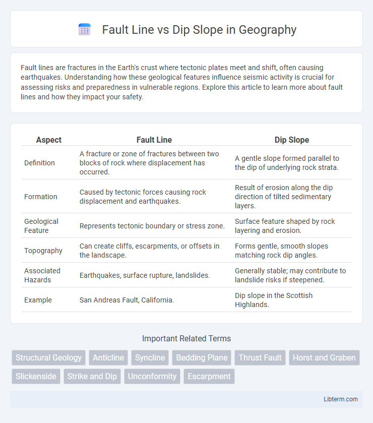
| Aspect | Fault Line | Dip Slope |
|---|---|---|
| Definition | A fracture or zone of fractures between two blocks of rock where displacement has occurred. | A gentle slope formed parallel to the dip of underlying rock strata. |
| Formation | Caused by tectonic forces causing rock displacement and earthquakes. | Result of erosion along the dip direction of tilted sedimentary layers. |
| Geological Feature | Represents tectonic boundary or stress zone. | Surface feature shaped by rock layering and erosion. |
| Topography | Can create cliffs, escarpments, or offsets in the landscape. | Forms gentle, smooth slopes matching rock dip angles. |
| Associated Hazards | Earthquakes, surface rupture, landslides. | Generally stable; may contribute to landslide risks if steepened. |
| Example | San Andreas Fault, California. | Dip slope in the Scottish Highlands. |
Introduction to Fault Lines and Dip Slopes
Fault lines are fractures in the Earth's crust where significant displacement has occurred due to tectonic forces, often causing earthquakes and shaping regional geology. Dip slopes are gentle inclines formed when sedimentary rock layers tilt uniformly, creating smooth, sloping landforms aligned with the bedding planes. Understanding the structural differences between fault lines and dip slopes is crucial for geological mapping, hazard assessment, and land use planning.
Geological Definitions
A fault line is a fracture in the Earth's crust where blocks of rock have slipped past each other, often causing earthquakes. A dip slope is a geological landform characterized by a gentle incline following the angle of the underlying strata or bedding planes. Fault lines represent zones of tectonic activity, whereas dip slopes reflect the structural orientation of sedimentary rock layers.
Formation Processes
Fault lines form through tectonic forces causing fractures and displacement along Earth's crust, often resulting from stress accumulation and sudden release during earthquakes. Dip slopes develop primarily by differential erosion along tilted stratified rock layers, where softer materials erode faster than harder layers, creating a sloping surface parallel to the rock dip. Both features are shaped by geological forces but differ as fault lines are structural breaks, while dip slopes are erosion-modified landforms.
Key Differences
Fault lines are fractures in the Earth's crust where significant displacement has occurred due to tectonic forces, often resulting in earthquakes and visible surface breaks. Dip slopes are gentle, inclined landforms shaped by sedimentary rock layers tilting at an angle, typically formed through erosion processes along the dip direction of strata. The key difference lies in fault lines representing active tectonic boundaries with structural shifts while dip slopes represent erosional landscapes aligned with rock layer dip angles.
Structural Characteristics
Fault lines are fractures in the Earth's crust where significant displacement has occurred, characterized by abrupt breaks and jagged surfaces that indicate intense tectonic stress. Dip slopes, on the other hand, are gentle inclined surfaces formed by the erosion of tilted rock layers, exhibiting uniform and gradual dips consistent with the bedding planes. Structural characteristics of fault lines include offset strata and fault scarps, while dip slopes display continuous, sloping rock formations aligned with the geological dip direction.
Examples Around the World
Fault lines, such as the San Andreas Fault in California, represent fractures where tectonic plates slide past each other, often causing earthquakes. Dip slopes, exemplified by the cuesta formations in the Appalachian Mountains, occur where rock layers tilt gently, creating asymmetric ridges and valleys. Both geological features shape landscapes globally but differ fundamentally in formation and seismic activity.
Influence on Landscape
Fault lines create abrupt changes in the landscape, producing features such as cliffs, escarpments, and valleys due to the displacement of rock layers along fractures. Dip slopes form more gradual inclines that follow the angle of strata, influencing erosion patterns and drainage systems by directing water flow downslope. The contrasting geomorphology of fault lines and dip slopes shapes terrain variability and impacts soil development, vegetation distribution, and human land use.
Hazards and Risks
Fault lines pose significant hazards due to their potential to generate violent earthquakes, causing ground rupture, infrastructure collapse, and landslides that threaten lives and property. Dip slopes, characterized by inclined rock strata, increase the risk of slope failures and rockfalls, especially during heavy rainfall or seismic activity, leading to localized damage and disruption. Understanding the distinct geological behaviors and associated risks of fault lines and dip slopes is essential for effective land-use planning and hazard mitigation strategies.
Importance in Earth Sciences
Fault lines reveal zones of crustal displacement crucial for understanding earthquake mechanics and tectonic stress distribution. Dip slopes indicate the angle of rock strata and help interpret sedimentary layering and geological history. Both features aid geologists in seismic hazard assessment and resource exploration.
Summary and Conclusion
Fault lines represent fractures in the Earth's crust where displacement has occurred, often leading to significant geological activity such as earthquakes. Dip slopes are inclined surfaces formed by the erosion of tilted rock layers, characterized by a gentle dip parallel to the bedding planes. Understanding the distinction between fault lines and dip slopes is crucial for assessing seismic risks and landscape evolution, as fault lines indicate tectonic movements while dip slopes reflect geomorphological processes.
Fault Line Infographic