Datum refers to a reference point or standard against which measurements are made, crucial in fields like surveying, engineering, and mapping for ensuring accuracy and consistency. It serves as a foundational element that helps interpret spatial data and align various measurement systems. Explore the rest of this article to understand how datum impacts your projects and why selecting the right datum is essential.
Table of Comparison
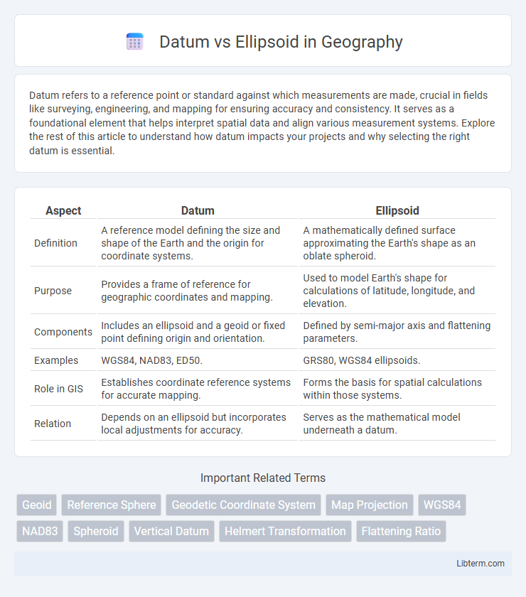
| Aspect | Datum | Ellipsoid |
|---|---|---|
| Definition | A reference model defining the size and shape of the Earth and the origin for coordinate systems. | A mathematically defined surface approximating the Earth's shape as an oblate spheroid. |
| Purpose | Provides a frame of reference for geographic coordinates and mapping. | Used to model Earth's shape for calculations of latitude, longitude, and elevation. |
| Components | Includes an ellipsoid and a geoid or fixed point defining origin and orientation. | Defined by semi-major axis and flattening parameters. |
| Examples | WGS84, NAD83, ED50. | GRS80, WGS84 ellipsoids. |
| Role in GIS | Establishes coordinate reference systems for accurate mapping. | Forms the basis for spatial calculations within those systems. |
| Relation | Depends on an ellipsoid but incorporates local adjustments for accuracy. | Serves as the mathematical model underneath a datum. |
Introduction to Geodetic Concepts
A datum is a foundational reference system that defines the origin and orientation of coordinates used in mapping and surveying, while an ellipsoid is a mathematically defined smooth surface that approximates the shape of the Earth. Geodetic concepts utilize ellipsoids to model the Earth's shape accurately, enabling precise coordinate calculations relative to a chosen datum. The relationship between a datum and its associated ellipsoid is critical for converting geospatial data across different mapping systems and applications.
Defining Datum and Ellipsoid
A datum is a reference framework used to measure locations on the Earth's surface, providing a base for geographic coordinate systems by defining the origin and orientation of latitude and longitude lines. An ellipsoid is a mathematically defined, smooth, and oblate spheroid shape that approximates the Earth's shape, serving as the standard model for geodetic calculations within the datum. The interaction between a datum and ellipsoid determines the accuracy of mapping and positioning by aligning the ellipsoid to fit the Earth's geoid in a specific region.
Key Differences Between Datum and Ellipsoid
A datum defines the origin and orientation of coordinate systems used for mapping and geolocation, providing a reference framework based on a specific ellipsoid model and real-world survey points. An ellipsoid is a mathematically defined smooth surface approximating the Earth's shape, characterized by parameters such as semi-major axis and flattening, but it does not account for local variations in the Earth's surface. Key differences include that a datum incorporates an ellipsoid along with a fixed reference point on the Earth's surface for precise positioning, while an ellipsoid alone serves as a geometric model without geodetic control points.
Historical Evolution of Geodetic Reference Systems
The historical evolution of geodetic reference systems began with the use of ellipsoids as simplified mathematical models of the Earth's shape to approximate its curvature and enable accurate mapping. Over time, geodetic datums were developed as localized coordinate systems anchored to specific reference points on the Earth's surface, incorporating both the ellipsoid models and surface measurements to improve positional accuracy. Modern geodetic reference systems integrate globally defined datums with sophisticated ellipsoid parameters, facilitating precise global navigation, surveying, and geospatial analysis.
Types of Ellipsoids Used in Mapping
Mapping relies on reference ellipsoids like WGS84, GRS80, and Clarke 1866, each calibrated for specific geographic regions and accuracy requirements. WGS84 serves as the global standard for GPS, while regional systems like NAD27 use Clarke 1866, and NAD83 is based on GRS80. These ellipsoids differ in dimensions such as semi-major axis and flattening, influencing how geodetic datums model the Earth's shape for precise coordinate measurement.
Types of Datums: Local vs Global
Local datums are designed to align with the Earth's surface in a specific region, providing precise mapping and surveying accuracy for localized areas by using a fixed reference point on the Earth's surface. Global datums, such as WGS84 or ITRF, model the entire Earth by using a center of mass origin, enabling consistent geospatial positioning and navigation worldwide. The choice between local and global datums impacts coordinate accuracy and transformation requirements for geospatial data integration across different regions.
How Datums and Ellipsoids Work Together
Datums provide a reference framework for measuring locations on the Earth's surface by defining the origin and orientation of coordinate systems, while ellipsoids offer a mathematical model that approximates the shape of the Earth. Together, datums use an ellipsoid as their underlying geometric shape to accurately represent the Earth's curvature and enable precise geospatial positioning. This combination allows for consistent map projections, navigation, and geographic data integration across different regions and applications.
Importance in GPS and Geospatial Applications
A datum provides a reference framework for accurately locating points on the Earth's surface by defining the origin and orientation of coordinate systems, essential for GPS accuracy and geospatial data integration. Ellipsoids model the Earth's shape as a smooth, mathematically defined surface, approximating the geoid to improve positional calculations and distance measurements. Precise GPS positioning relies on selecting the appropriate datum and corresponding ellipsoid to minimize errors and ensure consistent mapping and navigation results across different regions.
Datum and Ellipsoid Transformation Challenges
Datum and ellipsoid transformation challenges arise due to differences in geographic reference systems and shape approximations of the Earth, causing discrepancies in coordinate accuracy. Variations in local datums, tied to specific ellipsoids, lead to complex adjustments when converting between global and regional spatial data. Accurate transformation requires advanced geodetic models and algorithms to reconcile these differences for precise mapping and navigation applications.
Future Trends in Geodetic Referencing
Future trends in geodetic referencing emphasize integrating dynamic datums that account for tectonic plate movements in real-time, enhancing accuracy beyond traditional static ellipsoids. Advances in satellite geodesy and GNSS technology promote the adoption of globally consistent, time-dependent reference frames, improving applications in navigation, mapping, and Earth observation. Machine learning algorithms are increasingly used to refine geoid models, bridging discrepancies between physical datums and mathematical ellipsoids for more precise spatial data analysis.
Datum Infographic