Floodplains are low-lying areas adjacent to rivers and streams that are prone to periodic flooding, playing a crucial role in natural water management and ecosystem health. These regions support diverse plant and animal life while acting as natural buffers that reduce flood risk by absorbing excess water. Discover how understanding floodplain dynamics can help protect your property and contribute to sustainable land use in the rest of this article.
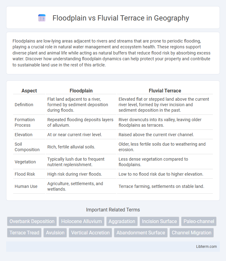
Table of Comparison
| Aspect | Floodplain | Fluvial Terrace |
|---|---|---|
| Definition | Flat land adjacent to a river, formed by sediment deposition during floods. | Elevated flat or stepped land above the current river level, formed by river incision and sediment deposition in the past. |
| Formation Process | Repeated flooding deposits layers of alluvium. | River downcuts into its valley, leaving older floodplains as terraces. |
| Elevation | At or near current river level. | Raised above the current river channel. |
| Soil Composition | Rich, fertile alluvial soils. | Older, less fertile soils due to weathering and erosion. |
| Vegetation | Typically lush due to frequent nutrient replenishment. | Less dense vegetation compared to floodplains. |
| Flood Risk | High risk during river floods. | Low to no flood risk due to higher elevation. |
| Human Use | Agriculture, settlements, and wetlands. | Terrace farming, settlements on stable land. |
Introduction to Floodplains and Fluvial Terraces
Floodplains are flat, low-lying areas adjacent to rivers, formed by sediment deposition during periodic flooding events, playing a crucial role in floodwater storage and nutrient-rich soil formation. Fluvial terraces are elevated landforms that represent former floodplain surfaces, created by river incision and changes in base level, providing insights into past river dynamics and climatic conditions. Understanding the distinction between floodplains and fluvial terraces is essential for flood management, ecological studies, and geomorphological research.
Defining Floodplains: Key Characteristics
Floodplains are flat, low-lying areas adjacent to rivers and streams, periodically inundated by floodwaters, rich in fertile alluvial soils due to sediment deposition. They serve as natural buffers, absorbing excess water during high-flow events, reducing flood risks downstream while supporting diverse ecosystems and agricultural activities. Unlike fluvial terraces, floodplains are actively shaped by ongoing river dynamics and seasonal flooding processes.
Understanding Fluvial Terraces
Fluvial terraces are elevated landforms adjacent to river valleys formed by the river's downcutting and changes in base level, contrasting with floodplains that lie directly at river level and are subject to regular flooding. Understanding fluvial terraces involves analyzing their formation through river incision, sediment deposition, and tectonic activity, which record past environmental conditions and river dynamics. These terraces provide critical insights into landscape evolution, flood history, and sedimentary processes over geological timescales.
Formation Processes: Floodplain vs Fluvial Terrace
Floodplains form through repetitive sediment deposition during periodic flooding events, creating flat areas adjacent to rivers. Fluvial terraces develop as rivers incise into their floodplains due to changes in base level or sediment supply, leaving elevated former floodplain surfaces. These terraces represent abandoned floodplains, marking previous river elevations shaped by erosional and depositional cycles.
Geomorphological Differences
Floodplains are low-lying, flat areas adjacent to rivers formed by sediment deposition during frequent flooding, characterized by fine-grained alluvium and active soil development. Fluvial terraces, in contrast, represent ancient floodplain surfaces elevated above the current river level due to river incision or tectonic uplift, composed of older, often coarser alluvial deposits that indicate past river stages. These geomorphological differences highlight floodplains as dynamic, currently active sedimentary environments, whereas fluvial terraces serve as geomorphic markers of former river positions and landscape evolution.
Hydrological Functions and Dynamics
Floodplains and fluvial terraces serve distinct hydrological functions in riverine landscapes. Floodplains act as dynamic zones absorbing excess water during high flow events, reducing downstream flooding and enhancing groundwater recharge through periodic inundation. Fluvial terraces, elevated above active river channels, represent past floodplain surfaces with limited current hydrological connectivity, often functioning as stable landforms with minimal influence on present-day flood attenuation and water storage.
Ecological Significance and Biodiversity
Floodplains support diverse ecosystems with fertile soils and abundant water, fostering rich biodiversity including amphibians, birds, and riparian plants. Fluvial terraces, elevated remnants of former floodplains, provide unique habitats with distinct vegetation and serve as refuges during floods, supporting species that prefer drier conditions. Both landforms contribute to landscape heterogeneity essential for ecological resilience and species diversity in riverine environments.
Human Impact and Land Use
Floodplains often support intensive agriculture and urban development due to their flat terrain and nutrient-rich soils, but these areas face higher flood risks that can disrupt communities and infrastructure. Fluvial terraces, elevated above active floodplains, provide more stable land for construction and farming with reduced flood hazards, yet they may be less fertile and require irrigation. Human impact on floodplains includes altered hydrology from dams and levees, while terraces are less directly affected but can experience changes from land clearance and quarrying.
Importance in River Management and Conservation
Floodplains play a critical role in river management by providing essential areas for water storage during floods, reducing downstream flood risks, and supporting diverse ecosystems that enhance biodiversity. Fluvial terraces serve as indicators of historical river dynamics and sediment deposition, offering valuable data for reconstructing past flood events and informing long-term river management strategies. Protecting and understanding both floodplains and fluvial terraces is vital for sustainable conservation efforts, as they contribute to habitat preservation, groundwater recharge, and climate resilience in riparian environments.
Summary: Choosing Between Floodplain and Fluvial Terrace
Floodplains are low-lying areas adjacent to rivers, characterized by frequent flooding and rich alluvial soils, making them ideal for agriculture but vulnerable to flood hazards. Fluvial terraces are elevated landforms formed by river incision, representing former floodplain levels, offering more stability and reduced flood risk but less fertile soil compared to active floodplains. Selecting between floodplain and fluvial terrace for land use depends on balancing flood risk, soil fertility, and long-term landscape stability.
Floodplain Infographic