Geographic Information Systems (GIS) enable the collection, analysis, and visualization of spatial data to reveal patterns and relationships across various environments. By integrating layers of geographic information, GIS supports decision-making in urban planning, environmental management, and disaster response. Discover how GIS technology can transform your understanding of spatial data in the rest of this article.
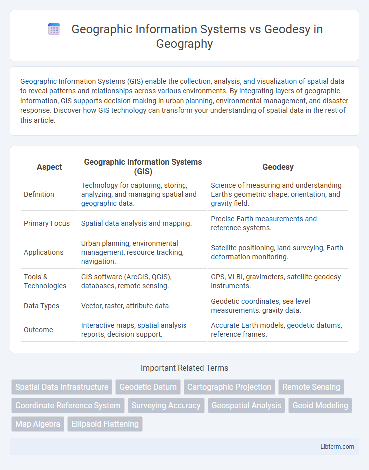
Table of Comparison
| Aspect | Geographic Information Systems (GIS) | Geodesy |
|---|---|---|
| Definition | Technology for capturing, storing, analyzing, and managing spatial and geographic data. | Science of measuring and understanding Earth's geometric shape, orientation, and gravity field. |
| Primary Focus | Spatial data analysis and mapping. | Precise Earth measurements and reference systems. |
| Applications | Urban planning, environmental management, resource tracking, navigation. | Satellite positioning, land surveying, Earth deformation monitoring. |
| Tools & Technologies | GIS software (ArcGIS, QGIS), databases, remote sensing. | GPS, VLBI, gravimeters, satellite geodesy instruments. |
| Data Types | Vector, raster, attribute data. | Geodetic coordinates, sea level measurements, gravity data. |
| Outcome | Interactive maps, spatial analysis reports, decision support. | Accurate Earth models, geodetic datums, reference frames. |
Introduction to Geographic Information Systems (GIS)
Geographic Information Systems (GIS) is a technology for capturing, storing, analyzing, and managing spatial and geographic data. Unlike Geodesy, which focuses on the precise measurement and representation of the Earth's shape and gravitational field, GIS integrates various data layers to visualize patterns and relationships across geographic spaces. GIS applications span urban planning, environmental management, and transportation, leveraging spatial analysis to support decision-making processes.
Fundamentals of Geodesy
Fundamentals of Geodesy involve the precise measurement and representation of the Earth's shape, gravitational field, and rotation, forming the scientific basis for mapping and spatial data accuracy. Geographic Information Systems (GIS) utilize geodetic data as a foundational reference to integrate, analyze, and visualize spatial information across diverse applications. The integration of geodesy ensures GIS datasets maintain geospatial integrity, enabling reliable positioning, navigation, and earth observation results.
Key Differences Between GIS and Geodesy
Geographic Information Systems (GIS) primarily focus on capturing, storing, analyzing, and visualizing spatial data for decision-making and mapping applications, while Geodesy deals with the precise measurement and understanding of Earth's geometric shape, gravitational field, and orientation in space. GIS integrates various data sources to manage spatial information across multiple disciplines, emphasizing data representation and analysis, whereas Geodesy emphasizes Earth measurement accuracy, coordinate systems, and satellite geolocation. The key differences lie in GIS's role as an applied tool for spatial data management versus Geodesy's fundamental scientific discipline centered on Earth measurement and geodetic principles.
Core Applications of Geographic Information Systems
Geographic Information Systems (GIS) primarily facilitate spatial data analysis, mapping, and visualization for urban planning, environmental management, and resource allocation, contrasting with geodesy's focus on precise Earth measurement and geodetic positioning. GIS integrates diverse datasets to support decision-making processes in infrastructure development, disaster response, and natural resource management by providing layered, interactive spatial representations. The core applications of GIS leverage remote sensing, database management, and spatial algorithms to enable real-time environmental monitoring, demographic analysis, and land-use planning at multiple scales.
Essential Roles of Geodesy in Mapping
Geodesy provides the fundamental spatial reference framework essential for accurate Geographic Information Systems (GIS) mapping by determining precise coordinates, elevations, and the Earth's shape. This geodetic data ensures GIS layers align correctly on the Earth's curved surface, enabling reliable spatial analysis and decision-making. Without geodesy's precise measurements and reference systems like WGS84 or ITRF, GIS mapping would lack the positional accuracy necessary for applications in navigation, land surveying, and environmental monitoring.
Integration of GIS and Geodesy in Modern Projects
The integration of Geographic Information Systems (GIS) and geodesy enhances the accuracy of spatial data by combining GIS's data management capabilities with geodesy's precise Earth measurements. Modern projects utilize this integration to improve mapping accuracy, infrastructure planning, and environmental monitoring by aligning geodetic control points with GIS datasets. This synergy enables real-time data updates and supports complex spatial analyses critical for urban development and disaster management.
Data Accuracy: Geodesy vs. GIS
Geodesy prioritizes supreme data accuracy by measuring Earth's geometric shape, orientation, and gravitational field with precise instruments like GPS and satellite laser ranging. Geographic Information Systems (GIS) integrate diverse spatial data but often depend on the source data's inherent accuracy and resolution, making GIS accuracy variable. The fundamental distinction lies in geodesy providing absolute reference frameworks, whereas GIS emphasizes spatial analysis and visualization built upon those geodetic foundations.
Technologies and Tools Used in GIS and Geodesy
Geographic Information Systems (GIS) utilize software platforms like ArcGIS, QGIS, and ERDAS Imagine, integrating spatial databases, remote sensing data, and GPS technology for mapping and spatial analysis. Geodesy employs high-precision instruments such as total stations, GNSS receivers, laser scanners, and satellite geodesy techniques including VLBI and SLR to measure Earth's shape, orientation, and gravitational field. While GIS emphasizes data visualization and spatial data management tools, geodesy focuses on precision measurement technologies for determining exact coordinates and geodetic control networks.
Challenges in Combining GIS and Geodetic Data
Combining Geographic Information Systems (GIS) and geodetic data presents challenges due to differences in data accuracy, coordinate systems, and temporal resolution. Geodetic data relies on precise measurements of the Earth's shape and gravitational field, requiring high accuracy often at the millimeter level, whereas GIS data is typically collected from diverse sources with varying accuracy standards. Integrating these datasets demands sophisticated transformation algorithms and rigorous quality control to ensure spatial consistency and reliability for applications in surveying, mapping, and Earth observation.
Future Trends: Evolving Synergies between GIS and Geodesy
Future trends indicate a growing integration between Geographic Information Systems (GIS) and Geodesy, driven by advancements in satellite navigation, remote sensing, and real-time data processing. Enhanced precision in geodetic measurements will support high-resolution spatial analysis within GIS platforms, enabling dynamic mapping and monitoring of environmental changes. The convergence of these technologies will facilitate more accurate geospatial intelligence for urban planning, disaster management, and autonomous system navigation.
Geographic Information Systems Infographic