Reference ellipsoids are mathematical models representing the Earth's shape, used in geodesy to approximate its surface for accurate mapping and navigation. They provide a smooth, regular shape that helps in defining coordinate systems and transforming satellite data into usable geographical information. Explore the rest of the article to understand how reference ellipsoids impact your GPS accuracy and geospatial studies.
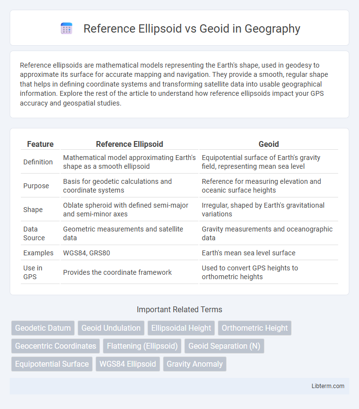
Table of Comparison
| Feature | Reference Ellipsoid | Geoid |
|---|---|---|
| Definition | Mathematical model approximating Earth's shape as a smooth ellipsoid | Equipotential surface of Earth's gravity field, representing mean sea level |
| Purpose | Basis for geodetic calculations and coordinate systems | Reference for measuring elevation and oceanic surface heights |
| Shape | Oblate spheroid with defined semi-major and semi-minor axes | Irregular, shaped by Earth's gravitational variations |
| Data Source | Geometric measurements and satellite data | Gravity measurements and oceanographic data |
| Examples | WGS84, GRS80 | Earth's mean sea level surface |
| Use in GPS | Provides the coordinate framework | Used to convert GPS heights to orthometric heights |
Introduction to Reference Ellipsoid and Geoid
The reference ellipsoid is a mathematically defined, smooth surface that approximates the shape of the Earth, serving as a foundational model for geodetic calculations and map projections. The geoid represents the Earth's mean sea level extended under the continents, reflecting variations in gravitational potential and providing a physically meaningful surface of equal gravitational potential. Distinguishing between the ellipsoid and geoid is essential for precise positioning, navigation, and understanding Earth's geophysical properties.
Definition of Reference Ellipsoid
The reference ellipsoid is a mathematically defined smooth, oblate spheroid used as a simplified model of the Earth's shape in geodesy. It approximates the Earth's size and shape by averaging the equatorial radius and polar radius, facilitating accurate calculations of latitude, longitude, and altitude. Unlike the geoid, which represents mean sea level considering gravitational variations, the reference ellipsoid serves as a regular, idealized surface for mapping and satellite navigation systems.
Definition of Geoid
The geoid is the hypothetical sea level surface of the Earth that corresponds to the mean gravitational potential, serving as a reference for measuring elevations. Unlike the reference ellipsoid, which is a mathematically defined smooth surface approximating the Earth's shape, the geoid reflects variations in the Earth's gravitational field caused by uneven mass distribution. It provides a more accurate representation of true vertical heights and is essential for precise geodetic and surveying applications.
Historical Development of Reference Surfaces
The historical development of reference surfaces began with the introduction of the reference ellipsoid in the 18th century, designed to approximate the Earth's shape mathematically using parameters like semi-major and semi-minor axes. The geoid concept emerged later, representing an equipotential gravitational surface that closely corresponds to mean sea level, accounting for Earth's irregular gravity field and topographical variations. Advances in geodesy, including satellite measurements and gravimetry, have refined the differences between the ellipsoid and geoid, enhancing precision in global positioning and mapping systems.
Mathematical Representation: Ellipsoid vs Geoid
The reference ellipsoid is mathematically defined by a smooth, regular quadratic surface characterized by its semi-major axis and flattening, providing a simplified, geometric model of the Earth's shape. In contrast, the geoid is a complex, irregular equipotential surface of the Earth's gravity field, defined mathematically by variations in gravitational potential that correspond to mean sea level. While the ellipsoid uses precise ellipsoidal equations for positioning, the geoid requires gravity measurements and geophysical models for its accurate mathematical representation.
Physical Characteristics and Distinctions
The reference ellipsoid is a mathematically defined surface approximating the Earth's shape as a smooth, oblate spheroid, used primarily for geodetic calculations and map projections. The geoid represents the Earth's mean sea level extended under the continents, reflecting variations in gravitational acceleration caused by uneven mass distribution within the Earth. Distinctions include the reference ellipsoid's simplicity and uniform curvature versus the geoid's irregular, complex surface that more accurately represents true vertical heights relative to gravity.
Applications in Geodesy and Mapping
The Reference Ellipsoid provides a mathematically defined, smooth, and regular surface used as a standard for latitude, longitude, and height measurements in geodesy and mapping, enabling precise coordinate systems and satellite navigation. The Geoid represents the Earth's mean sea level affected by gravitational variations, crucial for accurate elevation data and orthometric height determination in surveying and geophysical studies. Combining ellipsoid-based positioning with geoid height models ensures accurate topographic mapping, sea-level monitoring, and infrastructure development.
Global and Regional Models Comparison
The reference ellipsoid serves as a simplified mathematical model of the Earth's shape based on a smooth, oblate spheroid, facilitating global geodetic calculations and satellite positioning, while the geoid represents the Earth's mean sea level affected by gravitational variations, offering a more accurate surface for regional height and gravity studies. Global models, such as WGS84 for the reference ellipsoid, provide consistent frameworks for worldwide navigation and mapping, whereas regional geoid models like EGM2008 incorporate dense gravity measurements to refine local topography and sea level representations. Comparison between global and regional models reveals trade-offs in accuracy and computational complexity, with global ellipsoids optimized for uniformity and geoid models tailored to capture nuanced gravitational anomalies essential for precise geophysical and engineering applications.
Impact on GPS and Satellite Positioning
The reference ellipsoid serves as a mathematically defined surface approximating Earth's shape, providing a standardized framework for GPS and satellite positioning systems, which rely on its smooth geometry for calculating precise coordinates. The geoid, representing Earth's mean sea level influenced by gravitational variations, introduces critical corrections to ellipsoidal heights, ensuring satellite-derived positions reflect true elevations. Misalignment between the reference ellipsoid and geoid can cause geospatial errors; integrating geoid models into GPS processing enhances vertical accuracy crucial for applications such as mapping, navigation, and geodesy.
Summary: Choice Between Ellipsoid and Geoid
The choice between a reference ellipsoid and a geoid depends on the application's accuracy and purpose in geodesy and mapping. A reference ellipsoid provides a smooth, mathematically defined surface ideal for GPS positioning and global coordinate systems. The geoid, representing mean sea level variations due to Earth's gravity field, is essential for precise height measurements and understanding gravitational anomalies.
Reference Ellipsoid Infographic