Remote sensing utilizes satellite or aerial sensor technologies to collect and analyze information about the Earth's surface without physical contact. This technology aids in environmental monitoring, disaster management, agriculture, and urban planning by providing accurate and up-to-date data. Explore the full article to discover how remote sensing can enhance your understanding of our planet.
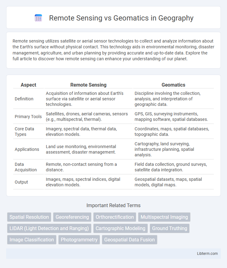
Table of Comparison
| Aspect | Remote Sensing | Geomatics |
|---|---|---|
| Definition | Acquisition of information about Earth's surface via satellite or aerial sensor technologies. | Discipline involving the collection, analysis, and interpretation of geographic data. |
| Primary Tools | Satellites, drones, aerial cameras, sensors (e.g., multispectral, thermal). | GPS, GIS, surveying instruments, mapping software, spatial databases. |
| Core Data Types | Imagery, spectral data, thermal data, elevation models. | Coordinates, maps, spatial databases, topographic data. |
| Applications | Land use monitoring, environmental assessment, disaster management. | Cartography, land surveying, infrastructure planning, spatial analysis. |
| Data Acquisition | Remote, non-contact sensing from a distance. | Field data collection, ground surveys, satellite data integration. |
| Output | Images, maps, spectral indices, digital elevation models. | Geospatial datasets, maps, spatial models, digital maps. |
Introduction to Remote Sensing and Geomatics
Remote sensing involves acquiring information about Earth's surface through satellite or aerial sensor technologies, enabling detailed environmental monitoring and resource management. Geomatics integrates techniques such as remote sensing, geographic information systems (GIS), and global positioning systems (GPS) to collect, analyze, and interpret spatial data for mapping and decision-making. The synergy of remote sensing technology and geomatics provides comprehensive tools for accurate spatial analysis and land-use planning.
Defining Remote Sensing
Remote sensing involves acquiring information about Earth's surface without direct contact, using satellite or aerial sensor technologies to detect and classify objects. It employs electromagnetic radiation to capture data across various spectral bands, enabling analysis of land use, vegetation, and environmental changes. Geomatics integrates remote sensing with GPS, GIS, and surveying to collect, analyze, and manage spatial data comprehensively.
What Is Geomatics?
Geomatics is an interdisciplinary field that integrates data acquisition, analysis, and management related to Earth's surface, leveraging technologies like GPS, GIS, and remote sensing to collect spatial information. It focuses on the design and use of tools for geospatial data processing, enabling precise mapping, land surveying, and spatial decision-making in various industries such as urban planning, agriculture, and environmental management. Unlike remote sensing, which primarily deals with data captured from satellite or aerial sensors, geomatics encompasses a broader range of methodologies including ground-based surveying and geospatial data interpretation.
Key Technologies in Remote Sensing
Key technologies in remote sensing include multispectral and hyperspectral imaging, LiDAR (Light Detection and Ranging), synthetic aperture radar (SAR), and thermal infrared sensors, which enable detailed environmental monitoring and data collection from satellite or airborne platforms. These technologies provide high-resolution spatial, spectral, and temporal data critical for applications such as land use mapping, climate studies, and disaster management. Remote sensing's ability to capture comprehensive geospatial information complements geomatics, which integrates this data for spatial analysis, modeling, and decision-making.
Essential Tools in Geomatics
Essential tools in geomatics include GPS technology, GIS software, total stations, and remote sensing instruments such as LiDAR and aerial imagery sensors. These tools enable precise data collection, spatial analysis, and mapping, supporting diverse applications from land surveying to environmental monitoring. The integration of remote sensing data enhances geomatics by providing high-resolution, real-time information critical for accurate spatial modeling and decision-making.
Major Applications of Remote Sensing
Remote sensing plays a crucial role in environmental monitoring, agriculture management, and disaster assessment by providing timely, high-resolution satellite and aerial imagery. This technology enables precise land-use mapping, vegetation health analysis, and climate change studies through multispectral and hyperspectral imaging techniques. Compared to geomatics, which integrates spatial data collection with geographic information systems (GIS) for broader geospatial analysis, remote sensing specifically focuses on data acquisition from a distance to monitor dynamic Earth surface processes.
Geomatics in Real-World Contexts
Geomatics integrates remote sensing, geographic information systems (GIS), and global navigation satellite systems (GNSS) to collect, analyze, and visualize spatial data for real-world applications. It supports urban planning, environmental management, and disaster response by providing precise geospatial data that enhances decision-making processes. By combining multiple data sources, geomatics enables accurate terrain modeling, infrastructure monitoring, and resource management essential for sustainable development.
Comparing Data Acquisition Methods
Remote sensing utilizes satellite or aerial sensors to capture data from a distance, enabling large-scale environmental monitoring without physical contact. Geomatics integrates various data acquisition methods, including surveying, GPS, and remote sensing, to collect precise spatial information for mapping and analysis. While remote sensing excels in broad area coverage and temporal data collection, geomatics combines multiple sources for enhanced accuracy and detailed spatial modeling.
Career Opportunities: Remote Sensing vs Geomatics
Remote sensing careers prioritize skills in satellite imagery analysis, environmental monitoring, and data interpretation for applications in agriculture, forestry, and disaster management. Geomatics professionals specialize in geographic information systems (GIS), surveying, spatial data management, and land development, offering roles in urban planning, infrastructure projects, and natural resource management. Both fields demand expertise in spatial technologies but diverge in industry focus, with remote sensing leaning towards environmental and earth sciences, while geomatics integrates more with engineering and planning sectors.
Future Trends and Innovations
Future trends in remote sensing include advancements in hyperspectral imaging, improved spatial resolution through nanosatellites, and AI-driven data analysis enhancing real-time environmental monitoring. Geomatics is evolving with the integration of Internet of Things (IoT) technologies, cloud-based geospatial data platforms, and augmented reality for precise field data collection and visualization. Innovations in both fields aim to improve accuracy, scalability, and accessibility of geospatial information for smart city planning, disaster management, and sustainable resource management.
Remote Sensing Infographic