Surveying is the process of measuring and mapping land boundaries, elevations, and features to support construction, land development, and legal documentation. Accurate surveying ensures that your projects are built correctly and comply with regulations, preventing costly disputes and delays. Explore the rest of the article to learn about different surveying techniques and their applications.
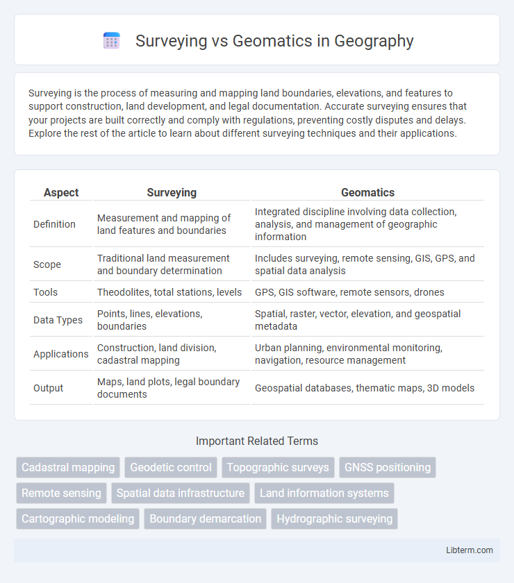
Table of Comparison
| Aspect | Surveying | Geomatics |
|---|---|---|
| Definition | Measurement and mapping of land features and boundaries | Integrated discipline involving data collection, analysis, and management of geographic information |
| Scope | Traditional land measurement and boundary determination | Includes surveying, remote sensing, GIS, GPS, and spatial data analysis |
| Tools | Theodolites, total stations, levels | GPS, GIS software, remote sensors, drones |
| Data Types | Points, lines, elevations, boundaries | Spatial, raster, vector, elevation, and geospatial metadata |
| Applications | Construction, land division, cadastral mapping | Urban planning, environmental monitoring, navigation, resource management |
| Output | Maps, land plots, legal boundary documents | Geospatial databases, thematic maps, 3D models |
Introduction to Surveying and Geomatics
Surveying involves measuring and mapping the physical features and boundaries of land through traditional techniques such as total stations, GPS, and levels. Geomatics extends surveying by integrating advanced technologies like Geographic Information Systems (GIS), remote sensing, and spatial data analysis to manage and interpret geographic information. Both disciplines are fundamental in fields like construction, land development, and environmental management, with geomatics offering a broader approach to spatial data collection and analysis.
Definitions: Surveying vs Geomatics
Surveying is the science and technique of measuring and mapping land features, boundaries, and topography to determine precise locations and dimensions. Geomatics encompasses a broader field that integrates surveying, geographic information systems (GIS), remote sensing, and spatial data management to collect, analyze, and interpret geographic information. While surveying focuses on physical measurement and layout, geomatics emphasizes data acquisition, processing, and application across various spatial disciplines.
Historical Evolution of Surveying and Geomatics
Surveying originated as a fundamental practice for land measurement and boundary determination, dating back to ancient civilizations such as Egypt and Mesopotamia, where basic tools like the Groma and theodolite were developed. The evolution of surveying progressed with the introduction of electronic distance measurement (EDM) devices and total stations in the 20th century, enhancing precision and efficiency. Geomatics emerged in the late 20th century as an integrated discipline, combining traditional surveying techniques with geographic information systems (GIS), remote sensing, and global navigation satellite systems (GNSS) to address complex spatial data management and analysis.
Core Principles of Surveying
Surveying is fundamentally grounded in precise measurements of distances, angles, and elevations to determine exact locations on the Earth's surface, utilizing instruments like total stations and GPS receivers. It prioritizes establishing accurate control points and benchmarks essential for mapping, construction, and land division. Core principles include accuracy, spatial data integrity, and the application of geodetic methods to ensure reliable positional information.
Core Principles of Geomatics
Geomatics integrates surveying with advanced technologies such as GPS, remote sensing, and geographic information systems (GIS) to collect, analyze, and manage spatial data. Core principles of geomatics emphasize accurate data acquisition, spatial analysis, and efficient data integration for diverse applications in mapping, land management, and environmental monitoring. Unlike traditional surveying, geomatics leverages digital tools and geospatial frameworks to enhance precision and enable complex spatial problem-solving.
Key Differences between Surveying and Geomatics
Surveying primarily involves measuring and mapping physical features and boundaries using traditional instruments like theodolites and total stations. Geomatics integrates advanced technologies such as GPS, remote sensing, and GIS to collect, analyze, and manage spatial data across diverse applications. The key difference lies in surveying's focus on precise land measurement, while geomatics encompasses a broader scope of spatial data processing and geospatial information systems.
Tools and Technologies in Surveying
Surveying employs traditional tools such as theodolites, total stations, and GPS receivers to measure land features with precision, while Geomatics integrates advanced technologies like LiDAR, remote sensing, and Geographic Information Systems (GIS) for comprehensive spatial data analysis and management. Surveying tools primarily focus on direct measurement and data acquisition in the field, whereas Geomatics leverages digital processing and geospatial modeling to interpret and visualize geographic information. Innovations in drone-based photogrammetry and 3D scanning further enhance surveying accuracy and efficiency, bridging the gap between conventional surveying methods and modern geomatics applications.
Modern Geomatics Techniques and Tools
Modern geomatics techniques leverage advanced technologies such as LiDAR, GNSS, and UAV-based photogrammetry to achieve high-precision spatial data acquisition and analysis. Unlike traditional surveying, geomatics integrates geographic information systems (GIS) and remote sensing tools for comprehensive mapping, modeling, and decision-making processes. This convergence of technologies enables efficient data collection, real-time processing, and enhanced accuracy in land measurement, infrastructure planning, and environmental monitoring.
Career Pathways: Surveyor vs Geomatics Professional
Surveyors primarily focus on measuring land, boundaries, and topography to support construction, legal, and land development projects, offering career opportunities in land surveying, cadastral surveying, and construction surveying. Geomatics professionals utilize advanced technologies like GIS, remote sensing, and GPS to analyze spatial data for industries such as environmental management, urban planning, and geospatial analytics, leading to roles in GIS specialist positions, spatial data analysts, and remote sensing experts. Both career pathways require strong technical skills but vary in specialization, with surveyors emphasizing field measurements and geomatics professionals concentrating on data integration and spatial analysis.
Future Trends in Surveying and Geomatics
Future trends in surveying and geomatics emphasize the integration of advanced technologies such as drone-based LiDAR, artificial intelligence, and real-time data processing for enhanced accuracy and efficiency. The adoption of Geographic Information Systems (GIS) combined with machine learning enables predictive analytics and smart urban planning. Increased use of autonomous surveying vehicles and augmented reality tools is transforming traditional workflows, driving innovation in spatial data collection and analysis.
Surveying Infographic