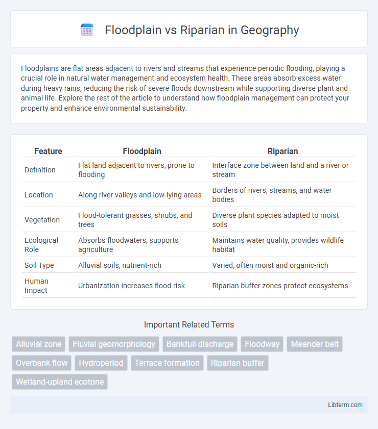
Floodplains are flat areas adjacent to rivers and streams that experience periodic flooding, playing a crucial role in natural water management and ecosystem health. These areas absorb excess water during heavy rains, reducing the risk of severe floods downstream while supporting diverse plant and animal life. Explore the rest of the article to understand how floodplain management can protect your property and enhance environmental sustainability.
Table of Comparison
| Feature | Floodplain | Riparian |
|---|---|---|
| Definition | Flat land adjacent to rivers, prone to flooding | Interface zone between land and a river or stream |
| Location | Along river valleys and low-lying areas | Borders of rivers, streams, and water bodies |
| Vegetation | Flood-tolerant grasses, shrubs, and trees | Diverse plant species adapted to moist soils |
| Ecological Role | Absorbs floodwaters, supports agriculture | Maintains water quality, provides wildlife habitat |
| Soil Type | Alluvial soils, nutrient-rich | Varied, often moist and organic-rich |
| Human Impact | Urbanization increases flood risk | Riparian buffer zones protect ecosystems |
Introduction to Floodplain and Riparian Zones
Floodplains are flat or gently sloping areas adjacent to rivers and streams that periodically flood, playing a critical role in water storage, nutrient cycling, and habitat diversity. Riparian zones are the interface between land and a river or stream, characterized by distinct vegetation and soil conditions influenced by the presence of water. Both floodplains and riparian zones contribute significantly to ecosystem health, water quality, and biodiversity conservation.
Defining Floodplain: Key Characteristics
A floodplain is a flat or nearly flat land area adjacent to a river or stream that experiences periodic flooding, characterized by rich alluvial soils and diverse ecosystems. It serves as a natural buffer by absorbing excess water during heavy rainfall, reducing downstream flood risks and enhancing groundwater recharge. Floodplain landscapes support unique vegetation adapted to wet conditions and play a critical role in maintaining water quality and habitat connectivity.
What is a Riparian Zone?
A riparian zone is the interface between land and a river or stream, characterized by distinct vegetation and soil types that support diverse ecosystems. These areas play a crucial role in stabilizing stream banks, filtering pollutants, and providing habitat for wildlife. Unlike broader floodplains, riparian zones specifically border water bodies and directly influence water quality and aquatic habitat health.
Geographic Location and Extent
Floodplains are extensive flat areas adjacent to rivers that experience periodic flooding, often stretching over wide geographic regions and serving as natural flood buffers. Riparian zones refer specifically to the narrow strips of land directly bordering riverbanks and streams, characterized by distinct vegetation influenced by proximity to water bodies. While floodplains cover broader landscapes and fluctuate with flood events, riparian areas are more localized and consistently situated along the immediate edges of waterways.
Hydrological Functions of Floodplains
Floodplains serve a crucial hydrological function by absorbing and slowing floodwaters, which reduces downstream flooding and recharges groundwater supplies. These areas act as natural buffers that store excess water during heavy rainfall, promoting sediment deposition and nutrient cycling essential to ecosystem health. Riparian zones, while adjacent to waterways and important for bank stabilization and habitat provision, do not typically hold the same volume or duration of floodwater storage as floodplains.
Ecological Roles of Riparian Areas
Riparian areas serve as critical ecological buffers along waterways, supporting biodiversity by providing habitat, food sources, and migration corridors for wildlife. These zones regulate water quality through sediment filtration and nutrient cycling, enhancing aquatic ecosystem health. Floodplains, in contrast, primarily dissipate flood energy and store excess water, but riparian zones offer continuous ecological functions essential for maintaining riparian and aquatic ecosystems.
Biodiversity and Habitat Differences
Floodplains support diverse ecosystems by providing nutrient-rich soils and periodic flooding that sustains wetland habitats essential for amphibians, birds, and fish spawning. Riparian zones, located along riverbanks, create unique microhabitats with dense vegetation that stabilizes banks and offers shade, critical for temperature-sensitive aquatic species and terrestrial wildlife corridors. The contrasting hydrological dynamics of floodplains and riparian areas result in distinct biodiversity patterns, with floodplains hosting more flood-adapted species and riparian zones favoring species dependent on continuous water availability and shelter.
Human Impact and Land Use Concerns
Floodplains, the flat areas adjacent to rivers prone to flooding, experience significant human impact from urban development, agriculture, and infrastructure projects that alter natural water flow and increase flood risk. Riparian zones, the interface between land and a river or stream, face land use concerns including deforestation, pollution, and habitat fragmentation that degrade water quality and biodiversity. Sustainable management of both floodplains and riparian areas is crucial to reducing flood damage, preserving ecosystems, and maintaining water resources.
Restoration and Conservation Strategies
Floodplain restoration prioritizes reestablishing natural hydrological processes by reconnecting rivers with their floodplains, enhancing groundwater recharge and nutrient cycling. Riparian conservation focuses on protecting and restoring vegetative buffers along stream banks to stabilize soil, reduce erosion, and improve habitat for aquatic and terrestrial species. Effective strategies integrate floodplain reconnection with riparian zone vegetation management to maximize ecosystem resilience and biodiversity.
Floodplain vs Riparian: Key Differences Summarized
Floodplains are low-lying areas adjacent to rivers and streams that experience periodic flooding, playing a crucial role in water storage and nutrient deposition. Riparian zones refer to the interface between land and a river or stream, characterized by unique vegetation that stabilizes banks and supports biodiversity. The key difference lies in floodplains being primarily flood-affected landscapes, while riparian areas specifically describe the biological and ecological zones alongside water bodies.
Floodplain Infographic

 libterm.com