Altimetry measures terrain elevation or sea surface height using radar or laser pulses, providing crucial data for mapping, climate studies, and navigation. Accurate altimetry supports understanding of landforms, ocean currents, and atmospheric changes, enhancing geographic and environmental research. Discover how altimetry impacts your world by exploring the full article.
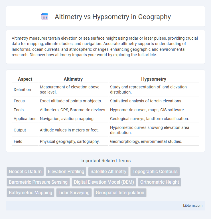
Table of Comparison
| Aspect | Altimetry | Hypsometry |
|---|---|---|
| Definition | Measurement of elevation above sea level. | Study and representation of land elevation distribution. |
| Focus | Exact altitude of points or objects. | Statistical analysis of terrain elevations. |
| Tools | Altimeters, GPS, Barometric devices. | Hypsometric curves, maps, GIS software. |
| Applications | Navigation, aviation, mapping. | Geological surveys, landform classification. |
| Output | Altitude values in meters or feet. | Hypsometric curves showing elevation area distribution. |
| Field | Physical geography, cartography. | Geomorphology, environmental studies. |
Introduction to Altimetry and Hypsometry
Altimetry measures elevation relative to sea level using satellite or radar technologies, providing precise vertical distance data for mapping and navigation. Hypsometry involves studying the distribution of land elevation, analyzing terrain features through elevation frequency and contour intervals to understand topographic variation. Both methods are essential in geospatial science for Earth surface analysis, with altimetry focusing on direct height measurement and hypsometry emphasizing elevation distribution patterns.
Defining Altimetry: Principles and Techniques
Altimetry refers to the scientific measurement of elevation or altitude above a reference level, primarily sea level, employing techniques such as radar, laser altimeters, and GPS. It involves capturing precise height data of surfaces like terrain, ocean floors, or ice sheets using satellite-based sensors or airborne instruments. Understanding altimetry's principles enables accurate topographical mapping, climate monitoring, and geospatial analysis in Earth sciences.
Understanding Hypsometry: Concepts and Methods
Hypsometry involves measuring land elevation relative to sea level using contour lines, digital elevation models (DEMs), or satellite data to create hypsometric curves that describe terrain distribution. This method quantifies the proportion of surface area at various altitudes, essential for geomorphological analysis, watershed management, and flood risk assessment. Understanding hypsometry enables accurate mapping of topographic variations and helps interpret landform evolution and environmental processes.
Key Differences Between Altimetry and Hypsometry
Altimetry measures the elevation of the Earth's surface relative to sea level using instruments like radar or satellite sensors, providing precise height data essential for topographic mapping and geospatial analysis. Hypsometry, on the other hand, involves the quantitative measurement and representation of land elevation distribution through hypsometric curves or maps that depict the proportion of area at various elevations. Key differences include altimetry's focus on obtaining specific point elevations, whereas hypsometry emphasizes the statistical analysis of elevation data to understand terrain characteristics and geomorphology.
Applications of Altimetry in Modern Science
Altimetry plays a crucial role in modern science by providing precise measurements of elevation and surface height, essential for applications such as climate monitoring, sea level rise analysis, and topographic mapping. Satellite altimetry enables detailed oceanographic studies by measuring sea surface height variations, aiding in understanding ocean currents and global circulation patterns. It also supports geophysical research through the assessment of land surface deformation, contributing to earthquake and volcanic activity monitoring.
Hypsometry Applications in Environmental Studies
Hypsometry, the measurement of land elevation relative to sea level, plays a crucial role in environmental studies by providing detailed data on terrain elevation distributions. This information aids in watershed management, soil erosion analysis, and habitat mapping, enabling scientists to assess ecological patterns and predict environmental changes. Hypsometric curves are used to evaluate landscape development stages and inform conservation strategies for sustainable land use planning.
Advantages and Limitations of Altimetry
Altimetry measures precise elevations above sea level using radar or laser instruments, offering high accuracy for topographic mapping and oceanography, while hypsometry analyzes land elevation by contour lines on maps. Altimetry advantages include direct elevation data acquisition, real-time measurements, and applicability over water bodies, but limitations involve signal interference from vegetation and atmospheric conditions, as well as reduced accuracy in rugged terrain. This technology excels in monitoring sea surface heights and ice sheet elevation changes, yet requires complementary methods for comprehensive landform analysis.
Strengths and Challenges of Hypsometry
Hypsometry excels in representing land elevation relative to sea level, providing detailed insights into terrain morphology and watershed analysis, crucial for environmental and geological studies. Its strength lies in the ability to use elevation data from various sources such as satellite imagery and topographic maps, allowing for high-resolution digital elevation models (DEMs). Challenges include handling data inaccuracies due to vegetation cover, urban structures, and the complexity of accurately modeling elevation changes in regions with steep or rugged landscapes.
Altimetry vs Hypsometry: Data Accuracy and Resolution
Altimetry measures surface elevation using satellite or airborne radar and laser data, providing highly accurate, high-resolution digital elevation models (DEMs) ideal for detailed terrain analysis. Hypsometry involves analyzing elevation distributions within a region based on contour mapping, which can vary in accuracy due to map scale and contour interval limitations. Altimetry's remote sensing technology delivers more consistent and precise elevation measurements compared to the often generalized and lower-resolution data inherent in hypsometric methods.
Future Trends in Elevation Measurement Technologies
Future trends in elevation measurement technologies emphasize integrating altimetry and hypsometry with advanced remote sensing tools such as LiDAR and radar interferometry, improving accuracy and resolution. Machine learning algorithms enhance data processing, enabling real-time terrain analysis and elevation mapping for diverse applications, including climate monitoring and urban planning. Innovations in satellite altimetry combined with high-definition digital elevation models (DEMs) facilitate precise monitoring of topographic changes and sea-level rise on a global scale.
Altimetry Infographic