Spatial analysis involves examining geographic patterns to understand relationships, trends, and behaviors within a specific area. By leveraging advanced geographic information system (GIS) tools, you can uncover insights that drive informed decision-making in urban planning, environmental management, and business logistics. Explore the rest of the article to discover how spatial analysis can transform your data into actionable knowledge.
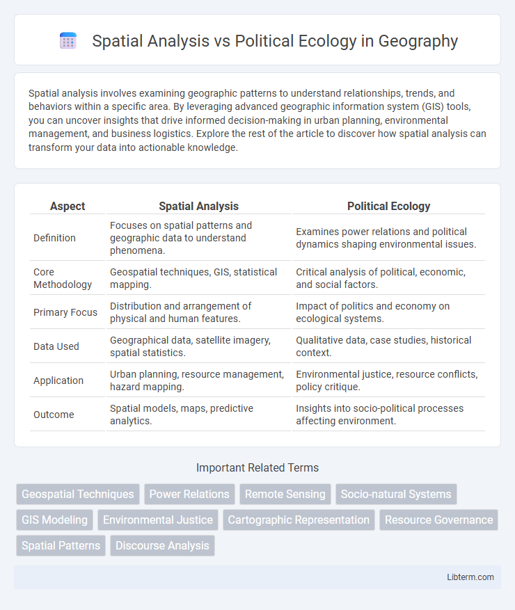
Table of Comparison
| Aspect | Spatial Analysis | Political Ecology |
|---|---|---|
| Definition | Focuses on spatial patterns and geographic data to understand phenomena. | Examines power relations and political dynamics shaping environmental issues. |
| Core Methodology | Geospatial techniques, GIS, statistical mapping. | Critical analysis of political, economic, and social factors. |
| Primary Focus | Distribution and arrangement of physical and human features. | Impact of politics and economy on ecological systems. |
| Data Used | Geographical data, satellite imagery, spatial statistics. | Qualitative data, case studies, historical context. |
| Application | Urban planning, resource management, hazard mapping. | Environmental justice, resource conflicts, policy critique. |
| Outcome | Spatial models, maps, predictive analytics. | Insights into socio-political processes affecting environment. |
Introduction to Spatial Analysis and Political Ecology
Spatial analysis involves examining geographic patterns and spatial relationships using quantitative methods such as GIS, remote sensing, and spatial statistics to interpret spatial data and inform decision-making. Political ecology explores the interactions between political, economic, and social factors with environmental issues, emphasizing power dynamics and socio-environmental conflicts. Both approaches provide complementary insights: spatial analysis offers precise mapping and pattern recognition, while political ecology emphasizes context, scale, and the influence of human agency on environmental change.
Core Concepts in Spatial Analysis
Spatial analysis centers on the examination of spatial data to identify patterns, relationships, and trends within geographic spaces, utilizing techniques such as spatial statistics, geographic information systems (GIS), and spatial modeling. Key concepts include spatial autocorrelation, scale, spatial heterogeneity, and spatial interpolation, which enable the quantification and visualization of spatial phenomena. Political ecology, in contrast, explores the relationships between political, economic, and social factors with environmental issues and changes, emphasizing power dynamics and human-environment interactions rather than purely spatial data.
Fundamental Principles of Political Ecology
Political ecology centers on understanding the relationships between political, economic, and social factors with environmental issues and changes, emphasizing power dynamics and conflicts over natural resource access and control. Spatial analysis, by contrast, involves the quantitative examination of geographic patterns to interpret environmental and social data without inherently addressing underlying political or economic power structures. The fundamental principles of political ecology highlight how environmental conditions are shaped by political-economic contexts, social inequalities, and historical processes, focusing on the interplay between human agency and environmental outcomes.
Methodological Differences Between the Two Approaches
Spatial analysis employs quantitative techniques and Geographic Information Systems (GIS) to map and analyze the distribution of environmental and social phenomena across physical space, emphasizing patterns, correlations, and spatial statistics. Political ecology integrates qualitative methods such as ethnography, historical analysis, and discourse analysis to explore power relations, socio-political contexts, and environmental justice implications within human-environment interactions. Methodologically, spatial analysis prioritizes data-driven spatial modeling and visualization, while political ecology focuses on critical interpretations of political economy and social dynamics affecting ecological issues.
Tools and Techniques in Spatial Analysis
Spatial analysis utilizes GIS software, remote sensing, and spatial statistics to map and interpret geographic patterns and relationships, enabling precise data visualization and modeling of environmental phenomena. Techniques such as spatial autocorrelation, hotspot detection, and network analysis provide quantitative insights into spatial distributions and interactions. Political ecology, while incorporating spatial data, often emphasizes qualitative methods and critical theory to examine the socio-political dimensions of environmental issues, making spatial analysis tools crucial for integrating empirical geographic data with socio-political interpretations.
Key Themes Explored in Political Ecology
Political ecology explores themes such as power dynamics, environmental justice, and the socio-political contexts shaping human-environment interactions. It emphasizes the influence of economic systems, governance, and social inequalities on resource distribution and environmental degradation. These themes highlight the interconnectedness of ecological issues with cultural, political, and economic factors, distinguishing political ecology from spatial analysis's focus on geographical patterns and spatial data.
Integration of Spatial Analysis in Political Ecology Research
Spatial analysis enhances political ecology research by providing precise tools for mapping and quantifying environmental and social variables, enabling a more nuanced understanding of human-environment interactions. Integrating GIS technologies and spatial statistics helps reveal patterns of resource distribution, land use changes, and environmental injustices that political ecology seeks to address. This combination fosters interdisciplinary insights, supporting more effective policy recommendations to mitigate ecological conflicts and promote sustainable resource management.
Case Studies: Spatial Analysis vs Political Ecology
Case studies in spatial analysis emphasize quantitative data mapping and geospatial patterns to understand phenomena such as urban growth or environmental changes. Political ecology case studies focus on power relations and socio-environmental conflicts, examining how economic and political forces shape resource distribution and environmental outcomes. Comparing these approaches reveals spatial analysis's strength in visualizing data distribution, while political ecology provides critical insights into systemic inequalities influencing ecological issues.
Strengths and Limitations of Each Approach
Spatial analysis excels in quantifying geographic patterns through GIS technology, enabling precise mapping and modeling of environmental and social data; however, it may overlook underlying political and social contexts affecting spatial phenomena. Political ecology provides critical insights into power dynamics and socio-environmental conflicts, revealing structural inequalities and historical processes, but it can lack the quantitative rigor and spatial specificity offered by spatial analysis. Combining spatial analysis with political ecology enhances understanding by integrating spatial data precision with deep socio-political critique, addressing both environmental patterns and their governance implications.
Future Directions for Interdisciplinary Research
Future directions for interdisciplinary research between spatial analysis and political ecology emphasize integrating geospatial technologies with critical socio-political frameworks to understand environmental inequalities more deeply. Advancements in remote sensing, GIS, and big data analytics enable finer-scale mapping of resource distribution and environmental impacts, supporting nuanced investigations into power dynamics and policy effects. Emerging collaborations aim to develop participatory spatial tools that empower marginalized communities and facilitate equitable environmental governance.
Spatial Analysis Infographic