A map visually represents geographic information, helping you navigate and understand spatial relationships between locations. It can range from simple road maps to complex topographic or thematic maps, each serving specific purposes like travel, planning, or education. Explore the rest of the article to discover how maps can enhance your navigation and geographical knowledge.
Table of Comparison
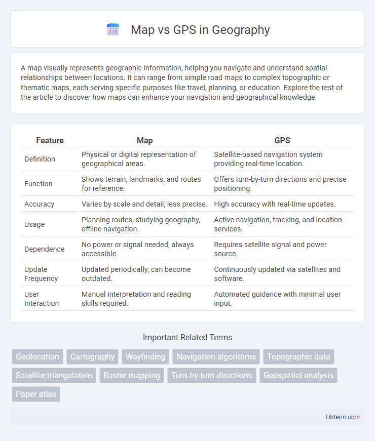
| Feature | Map | GPS |
|---|---|---|
| Definition | Physical or digital representation of geographical areas. | Satellite-based navigation system providing real-time location. |
| Function | Shows terrain, landmarks, and routes for reference. | Offers turn-by-turn directions and precise positioning. |
| Accuracy | Varies by scale and detail; less precise. | High accuracy with real-time updates. |
| Usage | Planning routes, studying geography, offline navigation. | Active navigation, tracking, and location services. |
| Dependence | No power or signal needed; always accessible. | Requires satellite signal and power source. |
| Update Frequency | Updated periodically; can become outdated. | Continuously updated via satellites and software. |
| User Interaction | Manual interpretation and reading skills required. | Automated guidance with minimal user input. |
Introduction: Understanding Map and GPS
Maps represent geographical information visually through symbols and scale, enabling users to interpret spatial relationships and navigate terrain manually. GPS (Global Positioning System) uses satellite signals to provide real-time location data, offering precise navigation and route guidance. Understanding both tools enhances spatial awareness, as maps provide contextual overview while GPS delivers dynamic positioning and directions.
Historical Evolution of Maps and GPS
Traditional maps date back to ancient civilizations, evolving from simple hand-drawn representations to detailed, accurate cartographic tools influenced by advancements in astronomy and surveying techniques. The development of GPS began in the 1970s with the U.S. Department of Defense's NAVSTAR system, providing real-time global positioning via a constellation of satellites. This transition from paper maps to satellite-based navigation marked a pivotal shift in geographic technology, offering unprecedented precision and accessibility.
What is a Traditional Map?
A traditional map is a physical or printed representation of geographic areas, displaying landmarks, roads, boundaries, and terrain features through symbols and labels. Unlike GPS, which provides real-time location tracking and navigation, traditional maps require manual reading and interpretation for route planning. These maps serve as essential tools in geography, education, and outdoor activities, offering a fixed overview of a region without dynamic updates.
How Does GPS Technology Work?
GPS technology operates through a network of at least 24 satellites orbiting Earth, which transmit signals to GPS receivers on the ground. The receiver calculates its precise location by measuring the time it takes for signals from multiple satellites to reach it, using a process called trilateration. This technology provides real-time position, speed, and time information, enabling accurate navigation and mapping compared to traditional paper maps.
Key Differences Between Maps and GPS
Maps provide a static, detailed representation of geographical features and routes, offering a broad overview useful for planning and understanding spatial relationships. GPS delivers real-time location tracking using satellite signals, enabling dynamic navigation and turn-by-turn directions tailored to the user's current position. Unlike traditional maps, GPS systems update instantly with traffic, route changes, and user movement, enhancing accuracy and convenience during travel.
Advantages of Using Maps
Maps offer a comprehensive visual representation of geographic areas, allowing users to understand spatial relationships and terrain features with ease. They require no power or signal, ensuring accessibility in remote locations where GPS devices may fail. Printed or digital, maps facilitate route planning and navigation without reliance on technology, making them indispensable tools for outdoor enthusiasts and professionals alike.
Benefits of Relying on GPS
GPS technology offers real-time, precise location tracking that constantly updates, enabling dynamic route adjustments and accurate navigation. Unlike traditional maps, GPS provides turn-by-turn directions, traffic updates, and estimated arrival times, enhancing efficiency for travelers and delivery services. This advanced functionality reduces the risk of getting lost and saves time, making GPS an indispensable tool for modern navigation.
Limitations of Both Map and GPS
Maps often lack real-time updates, making it difficult to navigate dynamic environments affected by traffic, construction, or road closures. GPS systems rely heavily on satellite signals, which can be obstructed by tall buildings, dense forests, or tunnels, leading to inaccurate positioning or signal loss. Both tools may fail in remote areas where cartographic data is outdated and satellite coverage is weak, limiting their overall reliability.
Situations Best Suited for Maps or GPS
Maps are ideal for planning long trips, understanding geographic context, and navigating areas with limited or no internet access. GPS excels in providing real-time directions, traffic updates, and location tracking during dynamic or unfamiliar routes. Combining both tools enhances navigation accuracy and preparedness in various travel scenarios.
Conclusion: Choosing the Right Navigation Tool
Selecting the appropriate navigation tool depends on your specific needs; maps offer broad geographical context and are invaluable for offline use or understanding terrain layout. GPS devices provide real-time, turn-by-turn directions and are ideal for dynamic route adjustments and immediate location tracking. Combining both tools can enhance navigation accuracy and reliability, especially in unfamiliar or complex environments.
Map Infographic