Remote sensing uses satellite or aerial sensor technologies to detect and classify objects on Earth by means of propagated signals. This technology is essential for monitoring environmental changes, urban development, and disaster management with high precision and over large areas. Explore the full article to understand how remote sensing can enhance your data collection and analysis strategies.
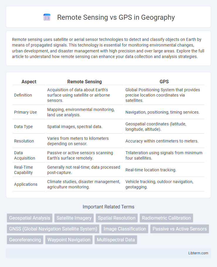
Table of Comparison
| Aspect | Remote Sensing | GPS |
|---|---|---|
| Definition | Acquisition of data about Earth's surface using satellite or airborne sensors. | Global Positioning System that provides precise location coordinates via satellites. |
| Primary Use | Mapping, environmental monitoring, land use analysis. | Navigation, positioning, timing services. |
| Data Type | Spatial images, spectral data. | Geospatial coordinates (latitude, longitude, altitude). |
| Resolution | Varies from meters to kilometers depending on sensor. | Accuracy within centimeters to meters. |
| Data Acquisition | Passive or active sensors scanning Earth's surface remotely. | Trilateration using signals from minimum four satellites. |
| Real-Time Capability | Generally not real-time; data processed post-capture. | Real-time location tracking. |
| Applications | Climate studies, disaster management, agriculture monitoring. | Vehicle tracking, outdoor navigation, geotagging. |
Introduction to Remote Sensing and GPS
Remote sensing involves acquiring information about Earth's surface through satellite or aerial sensor technologies, enabling the collection of data without direct contact. GPS (Global Positioning System) uses a network of satellites to provide precise location and timing information essential for navigation and mapping. Both technologies complement each other by enhancing geospatial analysis and environmental monitoring accuracy.
Key Principles of Remote Sensing
Remote sensing involves the acquisition of information about Earth's surface through sensors that detect and measure reflected or emitted electromagnetic radiation. It relies on principles such as sensor resolution, spectral signatures, and atmospheric interaction to capture data without direct contact. Unlike GPS, which provides precise location coordinates using satellite signals, remote sensing offers comprehensive spatial and temporal environmental data for analysis.
Fundamentals of GPS Technology
GPS technology relies on a constellation of at least 24 satellites orbiting Earth, transmitting precise time and positional data to receivers on the ground, enabling accurate geolocation anywhere on the planet. The system operates using trilateration, where a GPS receiver calculates its position by measuring the time delay of signals from multiple satellites. Unlike remote sensing, which captures extensive environmental data through sensors on satellites or aircraft, GPS fundamentals focus specifically on navigation and positioning through satellite signal processing.
Data Collection Methods in Remote Sensing
Remote sensing gathers data by capturing electromagnetic radiation reflected or emitted from the Earth's surface using sensors aboard satellites, aircraft, or drones, enabling wide-area observation without physical contact. These sensors operate in various spectral bands such as visible, infrared, and microwave, allowing detection of land use, vegetation health, and thermal properties. In contrast, GPS relies on trilateration from a network of satellites to provide precise positional data rather than environmental or spectral information.
Accuracy and Precision: Remote Sensing vs GPS
Remote sensing offers varying accuracy depending on the sensor type and resolution, typically ranging from a few meters to several kilometers, while GPS provides high positional accuracy, often within centimeters to meters under optimal conditions. Precision in GPS is consistently reliable due to satellite signal triangulation, whereas remote sensing precision depends on data processing algorithms and environmental factors. Combining both technologies enhances spatial data accuracy and precision for applications like mapping, environmental monitoring, and geospatial analysis.
Applications of Remote Sensing in Various Industries
Remote sensing technology is extensively used in agriculture for crop monitoring, precision farming, and detecting soil moisture levels, enabling better yield predictions and resource management. In environmental science, it plays a critical role in tracking deforestation, monitoring climate change effects, and managing natural disasters such as floods and wildfires. Urban planning and infrastructure development benefit from remote sensing data by facilitating land use analysis, transportation planning, and mapping of urban growth patterns.
Use Cases of GPS Across Fields
GPS technology enables precise location tracking and navigation across diverse fields such as transportation, agriculture, and emergency response. In agriculture, GPS supports precision farming by optimizing planting, fertilization, and harvesting processes to increase yield and reduce waste. Emergency services utilize GPS for rapid dispatch and real-time monitoring, enhancing response times and operational efficiency.
Advantages and Limitations: Remote Sensing vs GPS
Remote Sensing offers broad area coverage, enabling data collection over inaccessible or large regions through satellite or aerial imagery, which is ideal for environmental monitoring and land-use analysis. GPS provides precise location and navigation information with real-time positioning accuracy, crucial for transportation, mapping, and tracking applications. However, Remote Sensing faces limitations like cloud cover interference and lower spatial resolution, while GPS accuracy can be affected by signal obstruction, multipath errors, and limited performance indoors or under dense canopy.
Integration of Remote Sensing and GPS Technologies
Integration of remote sensing and GPS technologies enhances spatial data accuracy by combining high-resolution satellite imagery with precise geolocation coordinates. This synergy allows for improved environmental monitoring, mapping, and disaster management through real-time data collection and analysis. Leveraging both systems supports advanced geospatial applications such as precision agriculture, urban planning, and natural resource management.
Future Trends in Geospatial Technologies
Future trends in geospatial technologies highlight the integration of remote sensing with advanced GPS systems to enhance spatial accuracy and real-time data analysis. Emerging innovations include the fusion of satellite imagery from remote sensing with high-precision GPS for improved environmental monitoring, urban planning, and autonomous vehicle navigation. Artificial intelligence and machine learning algorithms are increasingly utilized to process vast geospatial datasets, driving smarter decision-making and predictive modeling in diverse applications.
Remote Sensing Infographic