Cartography is the science and art of creating maps that represent spatial information accurately and clearly. It combines geography, design, and technology to help you visualize and analyze the world around you. Explore the rest of this article to uncover the fascinating techniques and tools used in modern cartography.
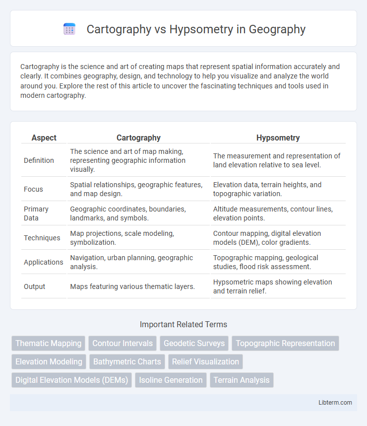
Table of Comparison
| Aspect | Cartography | Hypsometry |
|---|---|---|
| Definition | The science and art of map making, representing geographic information visually. | The measurement and representation of land elevation relative to sea level. |
| Focus | Spatial relationships, geographic features, and map design. | Elevation data, terrain heights, and topographic variation. |
| Primary Data | Geographic coordinates, boundaries, landmarks, and symbols. | Altitude measurements, contour lines, elevation points. |
| Techniques | Map projections, scale modeling, symbolization. | Contour mapping, digital elevation models (DEM), color gradients. |
| Applications | Navigation, urban planning, geographic analysis. | Topographic mapping, geological studies, flood risk assessment. |
| Output | Maps featuring various thematic layers. | Hypsometric maps showing elevation and terrain relief. |
Introduction to Cartography and Hypsometry
Cartography involves the science and art of creating maps that accurately represent geographical information using spatial data and visualization techniques. Hypsometry specifically measures land elevation relative to sea level, capturing terrain height variations critical for topographic maps and geographic analysis. Understanding hypsometric data enhances cartographic precision by integrating elevation contours and color gradients that reflect terrain relief on maps.
Defining Cartography
Cartography is the science and art of creating maps, emphasizing spatial relationships and geographic information representation through symbols, scales, and projections. It integrates data from various sources to produce visualizations that facilitate navigation, analysis, and planning. Hypsometry, by contrast, specifically measures land elevation and topographic variations, often represented in contour lines or color gradients on maps.
Understanding Hypsometry
Hypsometry measures land elevation relative to sea level, providing critical data for creating topographic maps and understanding terrain morphology. It utilizes contour lines and color gradients to represent elevation variation, aiding in geological and environmental analysis. Unlike general cartography, which encompasses all types of map-making, hypsometry specializes in quantifying and visualizing vertical landforms.
Key Differences Between Cartography and Hypsometry
Cartography involves the art and science of map-making, focusing on the representation of geographical information through symbols and scales, while hypsometry specifically measures land elevation relative to sea level. Cartographic maps provide a broad overview including political boundaries, roads, and physical features, whereas hypsometric maps use color gradients or contour lines to depict terrain elevation and relief. The key difference lies in hypsometry's specialized focus on elevation data, making it a crucial tool for geologists and environmental studies, unlike the more comprehensive spatial representation in cartography.
Applications of Cartography
Cartography offers vital applications in urban planning, disaster management, and navigation by creating accurate and visually informative maps that facilitate spatial decision-making. Its integration with Geographic Information Systems (GIS) enables the analysis of spatial data for resource management, environmental monitoring, and infrastructure development. Unlike hypsometry, which primarily measures land elevation and terrain relief, cartography encompasses broader spatial information, supporting diverse fields such as transportation logistics and demographic studies.
Uses of Hypsometry in Geography
Hypsometry plays a critical role in geography by measuring land elevation relative to sea level to create detailed topographic maps and understand terrain variations. It supports environmental planning, watershed management, and climate studies by analyzing altitude-related phenomena such as vegetation zones and temperature gradients. Geographic Information Systems (GIS) extensively use hypsometric data to enhance spatial analysis and model landform features with precision.
Techniques and Tools in Cartography
Cartography employs techniques such as thematic mapping, topographic mapping, and digital cartography using GIS (Geographic Information Systems) software, remote sensing, and satellite imagery to create accurate spatial representations. Tools like GPS devices, aerial photogrammetry, and computer-aided design (CAD) systems enhance map precision and enable dynamic data visualization in cartographic projects. In contrast, hypsometry primarily focuses on measuring land elevation using contour lines, hypsometric curves, and altimetric surveys supported by tools such as barometers, GPS altimeters, and digital elevation models (DEMs).
Methods of Hypsometric Analysis
Hypsometric analysis involves quantitative methods such as contour mapping, digital elevation models (DEMs), and hypsometric curves to study the distribution of elevation in a given terrain. Unlike traditional cartography, which focuses on the representation and design of maps, hypsometry emphasizes the measurement and interpretation of land surface elevations through techniques like remote sensing, GIS spatial analysis, and topographic profiling. These methods provide essential data for geomorphological studies, watershed management, and landscape evolution modeling.
Importance in Environmental and Earth Sciences
Cartography provides essential spatial representations that enable precise mapping and visualization of geographic features, facilitating environmental monitoring and land-use planning. Hypsometry, by measuring elevation distribution and terrain relief, is crucial for understanding watershed dynamics, erosion patterns, and climate zone delineation in earth sciences. Together, these disciplines support accurate environmental assessments, natural resource management, and hazard prediction models.
Future Trends in Cartography and Hypsometry
Future trends in cartography emphasize the integration of advanced geographic information systems (GIS) and real-time data visualization, enhancing map interactivity and accuracy. Hypsometry advances focus on high-resolution digital elevation models (DEMs) derived from LiDAR and satellite imagery, improving terrain analysis and environmental monitoring. Combining these technologies enables more precise spatial analysis and supports applications in urban planning, disaster management, and climate change research.
Cartography Infographic