Topography shapes the physical landscape by detailing the natural and artificial features of an area, including mountains, valleys, and urban developments. Accurate topographic maps are essential for planning construction projects, environmental management, and outdoor activities such as hiking. Explore the rest of the article to understand how topography impacts your environment and decision-making.
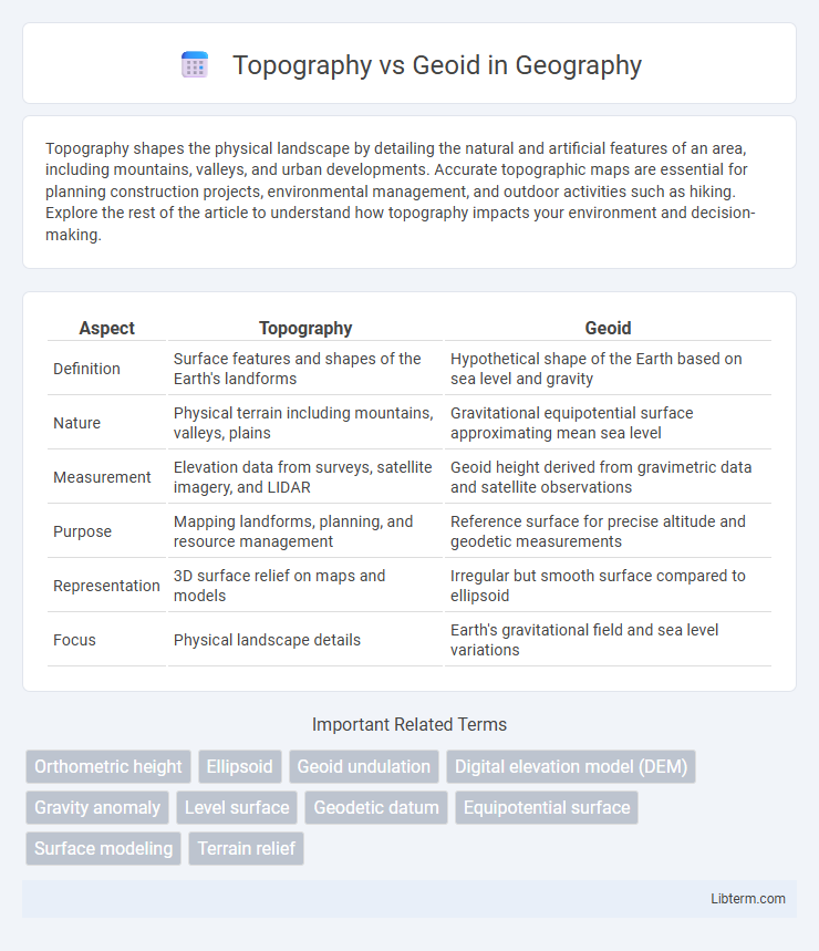
Table of Comparison
| Aspect | Topography | Geoid |
|---|---|---|
| Definition | Surface features and shapes of the Earth's landforms | Hypothetical shape of the Earth based on sea level and gravity |
| Nature | Physical terrain including mountains, valleys, plains | Gravitational equipotential surface approximating mean sea level |
| Measurement | Elevation data from surveys, satellite imagery, and LIDAR | Geoid height derived from gravimetric data and satellite observations |
| Purpose | Mapping landforms, planning, and resource management | Reference surface for precise altitude and geodetic measurements |
| Representation | 3D surface relief on maps and models | Irregular but smooth surface compared to ellipsoid |
| Focus | Physical landscape details | Earth's gravitational field and sea level variations |
Introduction to Topography and Geoid
Topography refers to the detailed mapping and description of the physical features of the Earth's surface, including mountains, valleys, and plains. The geoid represents the theoretical shape of the Earth, defined by global mean sea level and gravitational variations, serving as a reference surface for measuring elevation. Understanding the distinctions between topography and geoid is essential for accurate geospatial analysis, surveying, and mapping applications.
Defining Topography: Surface Features of Earth
Topography refers to the detailed mapping and description of Earth's surface features, including mountains, valleys, plains, and plateaus that define the landscape's shape and elevation. It captures the variations in terrain elevation relative to a reference point, typically sea level, providing critical data for construction, environmental studies, and navigation. Understanding topography allows for accurate modeling of watersheds, land use planning, and the assessment of geological hazards.
Understanding the Geoid: Earth's Gravity Shape
The geoid represents Earth's gravity-defined shape, reflecting variations in gravitational acceleration caused by uneven mass distribution within the planet. Unlike topography, which maps surface elevations relative to sea level, the geoid provides a hypothetical sea level surface extending globally, crucial for precise geodetic measurements and satellite navigation. Understanding the geoid enables accurate assessment of Earth's gravitational field, improving models used in oceanography, surveying, and geophysics.
Key Differences: Topography vs Geoid
Topography refers to the natural and artificial physical features of the Earth's surface, including mountains, valleys, and plains, while the geoid represents the equipotential surface of Earth's gravity field, approximating mean sea level globally. The key difference is that topography measures elevation relative to a reference surface, whereas the geoid defines a gravitationally consistent datum used to measure precise heights and sea level variations. Unlike topography, the geoid undulates due to variations in Earth's mass distribution, providing a complex but accurate model for geodetic and oceanographic applications.
Methods of Measuring Topography
Topography measurement primarily involves methods such as ground surveying, aerial photogrammetry, and LiDAR technology, which capture precise elevation and surface features. Ground surveying employs tools like theodolites and total stations to measure angles and distances, providing accurate local terrain data. LiDAR uses laser pulses from aerial platforms to generate detailed 3D topographic maps that reveal surface variations essential for geospatial analysis.
Techniques for Determining the Geoid
Techniques for determining the geoid primarily involve satellite gravimetry, which measures variations in Earth's gravitational field using satellites like GRACE and GOCE. Terrestrial gravimetry and precise leveling data complement satellite data by providing localized gravity measurements and elevation differences to refine geoid models. The integration of satellite altimetry over oceans further enhances geoid accuracy, enabling precise geoid height determination critical for topographic and geodetic applications.
Applications of Topography in Mapping and Engineering
Topography provides detailed elevation data essential for creating accurate maps and supporting engineering projects such as road construction, land development, and flood risk assessment. Precise topographic maps enable engineers to analyze terrain slopes, drainage patterns, and soil stability, optimizing design and minimizing environmental impact. Unlike the geoid, which represents Earth's mean sea level for gravity-based measurements, topography captures surface variations critical for practical applications in infrastructure planning and land use management.
Geoid Importance in Geodesy and Sea Level Measurements
The geoid represents the equipotential surface of Earth's gravity field, serving as a crucial reference for precise sea level measurements and geodetic surveys. Unlike topography, which describes Earth's surface elevations relative to a reference ellipsoid, the geoid accounts for gravitational variations, enabling accurate determination of mean sea level and vertical datums. Its importance in geodesy lies in providing a consistent and physically meaningful baseline for measuring altitude, ocean circulation, and tectonic movements.
Integration: Combining Topography and Geoid Data
Integrating topography and geoid data enhances the accuracy of Earth surface models by combining elevation measurements with gravitational potential information. This fusion allows precise determination of orthometric heights, improving geodetic computations and navigation systems. Advanced techniques like satellite gravimetry and digital elevation models enable seamless merging of these datasets for comprehensive terrain analysis.
Challenges and Future Trends in Earth Surface Science
Challenges in distinguishing topography from the geoid include accurately measuring Earth's surface elevations amidst gravitational variations and dynamic crustal movements. Advancements in satellite geodesy and gravimetry, such as GRACE and GOCE missions, are driving improvements in geoid modeling and separation of topographic signals. Future trends emphasize integrating high-resolution LiDAR data and AI-driven algorithms to enhance Earth surface representation, enabling precise geophysical and climate change studies.
Topography Infographic