Gradient refers to the rate of change in a quantity, often visualized as a slope or incline in mathematical and physical contexts. In machine learning, gradients guide the optimization process, enabling models to learn by adjusting parameters in the direction that reduces error. Explore the full article to understand how gradients impact various fields and improve your knowledge on this fundamental concept.
Table of Comparison
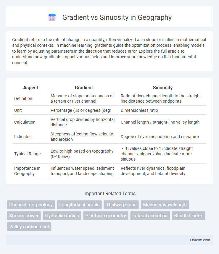
| Aspect | Gradient | Sinuosity |
|---|---|---|
| Definition | Measure of slope or steepness of a terrain or river channel | Ratio of river channel length to the straight-line distance between endpoints |
| Unit | Percentage (%) or degrees (deg) | Dimensionless ratio |
| Calculation | Vertical drop divided by horizontal distance | Channel length / straight-line valley length |
| Indicates | Steepness affecting flow velocity and erosion | Degree of river meandering and curvature |
| Typical Range | Low to high based on topography (0-100%+) | >=1; values close to 1 indicate straight channels, higher values indicate more sinuous |
| Importance in Geography | Influences water speed, sediment transport, and landscape shaping | Reflects river dynamics, floodplain development, and habitat diversity |
Introduction to Gradient and Sinuosity
Gradient measures the slope or steepness of a river channel, typically expressed as the vertical drop per unit of horizontal distance, influencing water velocity and sediment transport. Sinuosity quantifies the degree of curvature or meandering in a river's path by comparing the channel length to the straight-line distance between two points. Understanding gradient and sinuosity is essential for analyzing river morphology, flow dynamics, and sediment deposition processes.
Defining River Gradient
River gradient is the vertical drop of a river channel over a specified horizontal distance, typically expressed in meters per kilometer. This gradient influences the river's velocity, sediment transport capacity, and overall energy, directly affecting sinuosity, which measures the river's channel curvature or meandering pattern. Steeper gradients typically correspond to lower sinuosity with straighter channels, while gentler gradients promote higher sinuosity and more pronounced meanders.
Understanding River Sinuosity
River sinuosity measures the degree of curvature or meandering of a river channel relative to its straight-line distance, playing a crucial role in understanding river dynamics. Gradient, defined as the vertical drop per unit horizontal distance, influences flow velocity and sediment transport, directly affecting a river's tendency to develop sinuous patterns. High-gradient rivers typically have straighter channels with low sinuosity, while low-gradient rivers exhibit higher sinuosity due to reduced flow energy and increased lateral erosion.
Key Differences Between Gradient and Sinuosity
Gradient measures the vertical drop of a river or stream over a specific horizontal distance, expressed as a ratio or percentage, indicating flow steepness. Sinuosity quantifies the curvature of a river channel by comparing the channel length to the straight-line distance between two points, reflecting the degree of meandering. Key differences include gradient's influence on flow velocity and sediment transport versus sinuosity's role in channel shape and habitat diversity.
Factors Influencing River Gradient
River gradient is primarily influenced by factors such as tectonic activity, which alters the land elevation, and lithology, where resistant bedrock leads to steeper gradients compared to softer sediments. Climate impacts gradient indirectly through water discharge and sediment load, affecting erosion and deposition processes that modify slope steepness. Human activities, including dam construction and land use changes, also play a significant role in altering natural gradients by disrupting sediment transport and flow regimes.
Factors Affecting River Sinuosity
River sinuosity is significantly influenced by the gradient, with lower gradients typically promoting higher sinuosity due to reduced flow velocity allowing meander formation. Sediment type and volume, bank material cohesion, and vegetation density also play crucial roles in determining channel stability and meander migration rates. Human activities such as land use changes and water management can further alter natural sinuosity patterns by modifying flow regimes and sediment supply.
Methods for Measuring Gradient and Sinuosity
Gradient is typically measured using elevation data acquired through digital elevation models (DEMs) or topographic surveys, calculating the vertical drop over a specified horizontal distance to determine slope percentage or degrees. Sinuosity is quantified by dividing the channel length measured along the watercourse by the straight-line valley length between the same two points, often utilizing GIS tools or field mapping for precise measurement. Both metrics rely on high-resolution spatial data and accurate georeferencing to ensure reliable assessment of river morphology and channel behavior.
Impacts on River Morphology and Flow
Gradient influences river velocity and energy, directly affecting sediment transport and channel incision, while sinuosity controls flow complexity, promoting habitat diversity and altering erosion-deposition patterns. Steeper gradients often result in straighter, more erosive channels, whereas higher sinuosity increases flow resistance, leading to meandering patterns and floodplain development. Interactions between gradient and sinuosity shape river morphology by balancing erosive forces and deposition zones, impacting flood risks and ecosystem connectivity.
Environmental and Ecological Implications
Gradient influences water velocity and sediment transport, shaping aquatic habitats and nutrient distribution along river courses. Higher sinuosity often creates diverse microhabitats and floodplain complexity, promoting biodiversity and ecological resilience. Interactions between gradient and sinuosity critically determine erosion patterns, habitat connectivity, and ecosystem health in fluvial landscapes.
Conclusion: Choosing Between Gradient and Sinuosity
Selecting between gradient and sinuosity depends on the specific hydrological or geomorphological context being analyzed. Gradient offers a direct measure of slope and potential energy driving water flow, ideal for assessing erosion risk or sediment transport. Sinuosity reflects channel complexity and flow path efficiency, providing critical insights into river dynamics and habitat diversity.
Gradient Infographic