Curvature measures how sharply a curve bends at a given point and plays a crucial role in fields ranging from geometry to physics. Understanding curvature helps you analyze the shape and behavior of objects, whether in designing roads, studying particle paths, or computer graphics. Explore the rest of the article to uncover how curvature impacts various applications and why it is essential in your studies.
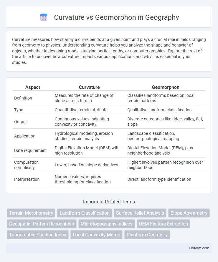
Table of Comparison
| Aspect | Curvature | Geomorphon |
|---|---|---|
| Definition | Measures the rate of change of slope across terrain | Classifies landforms based on local terrain patterns |
| Type | Quantitative terrain attribute | Qualitative landform classification |
| Output | Continuous values indicating convexity or concavity | Discrete categories like ridge, valley, flat, slope |
| Application | Hydrological modeling, erosion studies, terrain analysis | Landscape classification, geomorphological mapping |
| Data requirement | Digital Elevation Model (DEM) with high resolution | Digital Elevation Model (DEM), plus neighborhood analysis |
| Computation complexity | Lower; based on slope derivatives | Higher; involves pattern recognition over neighborhood |
| Interpretation | Numeric values, requires thresholding for classification | Direct landform type identification |
Understanding Curvature in Terrain Analysis
Curvature in terrain analysis quantifies the rate of change in slope or aspect, providing critical insight into surface shape and water flow patterns. Unlike Geomorphon, which classifies landforms based on local morphometric patterns, curvature offers a continuous measure that helps identify concave, convex, and flat areas, essential for erosion modeling and hydrological studies. Accurate calculation of curvature enhances terrain characterization by illuminating subtle variations in topography that impact soil movement and vegetation growth.
What Are Geomorphons?
Geomorphons are a classification method for landforms based on local terrain shape, categorizing surface patterns into distinct types like ridges, valleys, and plains using a pattern recognition approach. Unlike curvature, which measures the rate of change in slope at a point to identify convexity or concavity, geomorphons capture broader terrain morphology by analyzing neighborhood relationships in digital elevation models. This method enhances landscape characterization by simplifying complex topographic features into meaningful, consistent units applicable in geomorphology, hydrology, and environmental modeling.
Key Differences Between Curvature and Geomorphon Approaches
Curvature measures the rate of change in slope across terrain, providing detailed insights into landform shapes like ridges and valleys by analyzing continuous surface variations. Geomorphon, on the other hand, classifies landscape patterns into discrete morphometric forms such as peaks, ridges, and plains, using local neighborhood algorithms to capture terrain morphology. The key difference lies in Curvature's metric-based analysis of surface shape changes versus Geomorphon's categorical identification of terrain features for detailed geomorphological mapping.
Applications of Curvature Methods in Geospatial Studies
Curvature methods in geospatial studies provide detailed analyses of terrain shapes, enabling precise identification of landforms such as ridges, valleys, and slopes critical for hydrological modeling and erosion assessment. Unlike Geomorphon classification, which categorizes landforms into discrete types, curvature focuses on continuous surface properties facilitating fine-scale topographic variation mapping essential for urban planning and environmental monitoring. These methods enhance spatial accuracy in applications like landslide susceptibility mapping and soil moisture estimation, supporting more informed decision-making in natural resource management.
Geomorphon-Based Landform Classification
Geomorphon-based landform classification enhances terrain analysis by accurately identifying landforms through pattern recognition of local elevation variations, offering detailed categorization beyond basic curvature metrics. Unlike curvature methods that primarily focus on slope and convexity or concavity, geomorphons capture complex landform features such as ridges, valleys, and plains by analyzing the spatial configuration of elevation points within a moving window. This approach improves the precision of topographic mapping and supports applications in geomorphology, hydrology, and environmental planning by providing semantically rich terrain descriptors.
Data Requirements for Curvature and Geomorphon Analysis
Curvature analysis requires high-resolution digital elevation models (DEMs) with precise elevation data to accurately measure terrain convexity and concavity, as it relies on calculating second derivatives of the surface. Geomorphon analysis depends on DEMs with sufficient spatial resolution to identify and classify landform patterns by comparing local neighborhoods and elevation profiles, but it typically tolerates coarser resolutions than curvature. Both methods demand minimal noise and well-processed DEMs to ensure reliable terrain feature extraction, though curvature is more sensitive to data quality and resolution variations.
Accuracy and Resolution: Curvature vs Geomorphons
Curvature provides continuous, high-resolution surface detail by measuring the rate of change in slope, enabling precise detection of subtle terrain variations. Geomorphons classify landforms into discrete categories based on local shape patterns, offering clear but coarser spatial resolution suited for general landscape analysis. Curvature excels in accuracy for fine-scale topographic features, while geomorphons deliver semantically rich, interpretable landform maps with moderate spatial precision.
Computational Efficiency Comparison
Curvature analysis typically demands higher computational resources due to its reliance on differential geometry calculations and continuous surface derivatives, resulting in increased processing time and memory usage compared to geomorphon methods. Geomorphon classification leverages discrete pattern recognition on local terrain attributes, enabling faster execution and reduced computational complexity, particularly beneficial for large-scale digital elevation models (DEMs). Studies show geomorphon approaches achieve real-time performance in landscape analysis tasks, whereas curvature methods often require optimized algorithms or parallel processing to approach similar efficiency levels.
Integrating Curvature and Geomorphons in GIS
Integrating curvature and geomorphons in GIS enhances terrain analysis accuracy by combining curvature's ability to quantify surface shape with geomorphons' categorical landform classification. This integration allows for detailed identification of microtopographic features and improved modeling of hydrological processes, erosion risk, and landform development. Advanced GIS tools facilitate the simultaneous processing of curvature metrics and geomorphon patterns, supporting comprehensive geomorphological studies and environmental management.
Choosing the Right Technique for Your Geospatial Project
Curvature analysis excels in detecting terrain features by measuring the rate of elevation change, making it ideal for projects requiring detailed slope and landform assessments. Geomorphon classification offers a more generalized landform categorization by identifying morphological patterns based on local terrain shapes, which suits large-scale landscape analysis. Selecting between curvature and geomorphon methods depends on project goals: choose curvature for precise morphological quantification and geomorphon for thematic terrain mapping and geomorphological interpretation.
Curvature Infographic